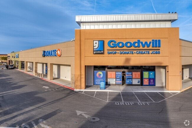
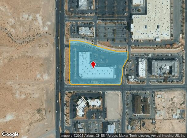
Property Record
7680 Las Vegas Blvd S, Las Vegas, NV 89123
NEARBY LISTINGS FOR SALE OR LEASE
Property Detail
7680 Las Vegas Blvd S
Las Vegas-Henderson-Paradise, NV
Belz Factory Outlet Stores-Phase 2
177-09-210-005
BELZ FACTORY OUTLET STORES-PHASE 2 PLAT BOOK 73 PAGE 39 PT LOT 1
Storebuilding
Clark
AE
Nevada
32003C2566F
1
2025
5.12 AC
2025
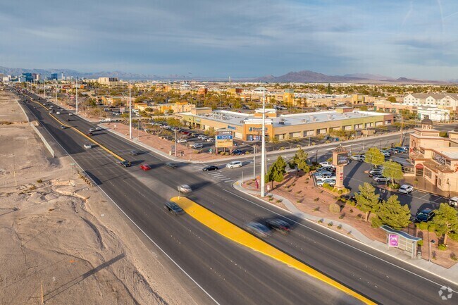
Southeast Las Vegas
002837
Las Vegas
51,875 SF
DEMOGRAPHICS near 7680 Las Vegas Blvd S
1 Mile
3 Mile
5 Mile
2024 Total Population
3,636
82,413
350,131
2029 Population
3,883
88,454
377,767
Pop Growth 2024-2029
+ 6.79%
+ 7.33%
+ 7.89%
Average Age
44
40
39
2024 Total Households
1,563
33,097
140,058
HH Growth 2024-2029
+ 6.78%
+ 7.27%
+ 7.79%
Median Household Inc
$77,192
$73,362
$67,549
Avg Household Size
2.30
2.40
2.40
2024 Avg HH Vehicles
2.00
2.00
2.00
Median Home Value
$487,902
$378,495
$393,094
Median Year Built
1996
1997
1998
Nearby Places
Map Layers
Map Styles
 Street
 Aerial
- Restaurants
- Banks
- Shops
- Fitness
- Groceries
PUBLIC TRANSPORTATION
AIRPORT
Harry Reid International
DRIVE
WALK
Distance
Harry Reid International
8 min
4.2 mi
Boulder City Municipal
DRIVE
WALK
Distance
Boulder City Municipal
33 min
22.5 mi
SALE & LEASE HISTORY
LISTING DATE
SALE/LEASE

Sep 24, 2016
For Lease
May 13, 2019
For Lease
Mar 31, 2017
For Lease
Feb 21, 2019
For Lease
Aug 16, 2018
For Sale
Nearby Properties
Address
Land Use
TOTAL SIZE
Lot Size
Zoning
Address
Land Use
TOTAL SIZE
Lot Size
Zoning
2,000,377 SF
118.89 AC
Address
Land Use
TOTAL SIZE
Lot Size
Zoning
937,376 SF
59.19 AC
Address
Land Use
TOTAL SIZE
Lot Size
Zoning
2,340,130 SF
56.10 AC
H1
Address
Land Use
TOTAL SIZE
Lot Size
Zoning
764,918 SF
94.41 AC
H1
Address
Land Use
TOTAL SIZE
Lot Size
Zoning
321,990 SF
76.15 AC
PF
Address
Land Use
TOTAL SIZE
Lot Size
Zoning
391,021 SF
40.14 AC
Address
Land Use
TOTAL SIZE
Lot Size
Zoning
35.25 AC
MD
Address
Land Use
TOTAL SIZE
Lot Size
Zoning
257,910 SF
31.47 AC
Address
Land Use
TOTAL SIZE
Lot Size
Zoning
459,983 SF
12.65 AC
M1
Address
Land Use
TOTAL SIZE
Lot Size
Zoning
66.26 AC
RE
Address
Land Use
TOTAL SIZE
Lot Size
Zoning
317,500 SF
19.26 AC
Address
Land Use
TOTAL SIZE
Lot Size
Zoning
353,690 SF
17.23 AC
Address
Land Use
TOTAL SIZE
Lot Size
Zoning
262,750 SF
17.95 AC
Address
Land Use
TOTAL SIZE
Lot Size
Zoning
930,204 SF
53.28 AC
MD
Address
Land Use
TOTAL SIZE
Lot Size
Zoning
222,625 SF
16.99 AC
Address
Land Use
TOTAL SIZE
Lot Size
Zoning
239,500 SF
13.18 AC
Address
Land Use
TOTAL SIZE
Lot Size
Zoning
18.08 AC
RE
Address
Land Use
TOTAL SIZE
Lot Size
Zoning
4,405 SF
19.79 AC
Address
Land Use
TOTAL SIZE
Lot Size
Zoning
4,444 SF
18.11 AC
Address
Land Use
TOTAL SIZE
Lot Size
Zoning
399,206 SF
22.06 AC
MD
Address
Land Use
TOTAL SIZE
Lot Size
Zoning
117.50 AC
Address
Land Use
TOTAL SIZE
Lot Size
Zoning
402,610 SF
15.51 AC
R3
Address
Land Use
TOTAL SIZE
Lot Size
Zoning
6,782 SF
17.45 AC
R3
Address
Land Use
TOTAL SIZE
Lot Size
Zoning
9,164 SF
22.81 AC
R3
Address
Land Use
TOTAL SIZE
Lot Size
Zoning
342,768 SF
28.30 AC
H1
Address
Land Use
TOTAL SIZE
Lot Size
Zoning
329,135 SF
18.94 AC
Address
Land Use
TOTAL SIZE
Lot Size
Zoning
3,148 SF
18.80 AC
R3
Address
Land Use
TOTAL SIZE
Lot Size
Zoning
526,284 SF
30.18 AC
Address
Land Use
TOTAL SIZE
Lot Size
Zoning
31.57 AC
H1
Address
Land Use
TOTAL SIZE
Lot Size
Zoning
267,640 SF
15.89 AC
The World's #1 Commercial Real Estate Marketplace
Connect with us
© 2025 CoStar Group
The information above has been obtained from sources believed reliable. While we do not doubt its accuracy we have not verified it and make no guarantee, warranty or representation about it. It is your responsibility to independently confirm its accuracy and completeness. Any projections, opinions, assumptions, or estimates used are for example only and do not represent the current or future performance of the property. The value of this transaction to you depends on tax and other factors which should be evaluated by your tax, financial, and legal advisors. You and your advisors should conduct a careful, independent investigation of the property to determine to your satisfaction the suitability of the property for your needs.