Property Record
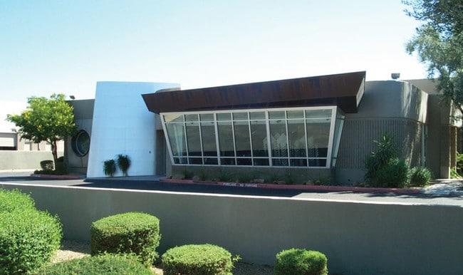
7681 E Gray Rd, Scottsdale, AZ 85260

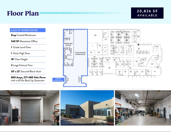
Current Lease Availabilities
Property Detail
7681 E Gray Rd
215-56-199
SCOTTSDALE INDUSTRIAL AIRPARK NO. 5 MCR 203-43
Warehouse
Maricopa
I-P
Arizona
C and X Area of minimal flood hazard, usually depicted on FIRMs as above the 500-year flood level.
109
2025
1.38 AC
2025
Scottsdale Airpark
216816
Phoenix
19,916 SF
Phoenix-Mesa-Chandler, AZ
NEARBY LISTINGS FOR SALE OR LEASE
DEMOGRAPHICS near 7681 E Gray Rd
1 mile
3 mile
5 mile
2025 Total Population
4,188
83,688
209,017
2030 Population
4,564
88,287
219,612
Pop Growth 2025-2030
+ 8.98%
+ 5.50%
+ 5.07%
Average Age
44
44
45
2025 Total Households
1,823
38,385
93,871
HH Growth 2025-2030
+ 9.33%
+ 5.84%
+ 5.36%
Median Household Inc
$128,230
$110,581
$113,479
Avg Household Size
2.20
2.10
2.20
2025 Avg HH Vehicles
2.00
2.00
2.00
Median Home Value
$901,935
$776,947
$788,987
Median Year Built
1993
1991
1990
Nearby Places
Map Layers
Map Styles
 Street
 Aerial
Layers
 Traffic
 Biking
Places
Listings with unknown addresses are not visible on the map
- Restaurants
- Banks
- Shops
- Fitness
- Groceries
PUBLIC TRANSPORTATION
AIRPORT
Phoenix Sky Harbor International
Drive
Walk
Distance
Phoenix Sky Harbor International
30 min
20.9 mi
Phoenix-Mesa Gateway
Drive
Walk
Distance
Phoenix-Mesa Gateway
51 min
36.3 mi
Nearby Properties
Address
Land Use
TOTAL SIZE
Lot Size
Zoning
Address
Land Use
TOTAL SIZE
Lot Size
Zoning
1,293,284 SF
14.50 AC
C-R
Address
Land Use
TOTAL SIZE
Lot Size
Zoning
3.15 AC
I-P
Address
Land Use
TOTAL SIZE
Lot Size
Zoning
667,688 SF
277.21 AC
Address
Land Use
TOTAL SIZE
Lot Size
Zoning
694,644 SF
34.41 AC
C-C
Address
Land Use
TOTAL SIZE
Lot Size
Zoning
500,010 SF
4.52 AC
PF
Address
Land Use
TOTAL SIZE
Lot Size
Zoning
794,304 SF
14.59 AC
WTP
Address
Land Use
TOTAL SIZE
Lot Size
Zoning
367,367 SF
37.89 AC
R-43
Address
Land Use
TOTAL SIZE
Lot Size
Zoning
762,044 SF
16.66 AC
I1
Address
Land Use
TOTAL SIZE
Lot Size
Zoning
7,803 SF
2.31 AC
I-P
Address
Land Use
TOTAL SIZE
Lot Size
Zoning
368,657 SF
40.11 AC
Address
Land Use
TOTAL SIZE
Lot Size
Zoning
514,088 SF
6.70 AC
PAD
Address
Land Use
TOTAL SIZE
Lot Size
Zoning
533,288 SF
18.61 AC
I-P
Address
Land Use
TOTAL SIZE
Lot Size
Zoning
428,891 SF
6.48 AC
PAD
Address
Land Use
TOTAL SIZE
Lot Size
Zoning
707,542 SF
28.49 AC
R-3A
Address
Land Use
TOTAL SIZE
Lot Size
Zoning
421,002 SF
23.48 AC
Address
Land Use
TOTAL SIZE
Lot Size
Zoning
824,672 SF
11.52 AC
Address
Land Use
TOTAL SIZE
Lot Size
Zoning
884,258 SF
30.63 AC
PCD
Address
Land Use
TOTAL SIZE
Lot Size
Zoning
497,704 SF
6.77 AC
Address
Land Use
TOTAL SIZE
Lot Size
Zoning
9,232 SF
4.07 AC
R-35
Address
Land Use
TOTAL SIZE
Lot Size
Zoning
355,757 SF
32.44 AC
C-R
Address
Land Use
TOTAL SIZE
Lot Size
Zoning
337,668 SF
8.14 AC
PAD
Address
Land Use
TOTAL SIZE
Lot Size
Zoning
417,831 SF
2.68 AC
C-R
Address
Land Use
TOTAL SIZE
Lot Size
Zoning
542,795 SF
5.56 AC
PCP
Address
Land Use
TOTAL SIZE
Lot Size
Zoning
530,588 SF
20.58 AC
C-C
Address
Land Use
TOTAL SIZE
Lot Size
Zoning
494,970 SF
4.90 AC
PUD
Address
Land Use
TOTAL SIZE
Lot Size
Zoning
495,877 SF
21.08 AC
C-C
Address
Land Use
TOTAL SIZE
Lot Size
Zoning
580,604 SF
7.52 AC
C-T
Address
Land Use
TOTAL SIZE
Lot Size
Zoning
88.08 AC
W-P
Address
Land Use
TOTAL SIZE
Lot Size
Zoning
Address
Land Use
TOTAL SIZE
Lot Size
Zoning
423,600 SF
5.13 AC
I1
The World's #1 Commercial Real Estate Marketplace
Connect with us
© 2026 CoStar Group
The information above has been obtained from sources believed reliable. While we do not doubt its accuracy we have not verified it and make no guarantee, warranty or representation about it. It is your responsibility to independently confirm its accuracy and completeness. Any projections, opinions, assumptions, or estimates used are for example only and do not represent the current or future performance of the property. The value of this transaction to you depends on tax and other factors which should be evaluated by your tax, financial, and legal advisors. You and your advisors should conduct a careful, independent investigation of the property to determine to your satisfaction the suitability of the property for your needs.