Property Record
7681 State Route 104, Oswego, NY 13126
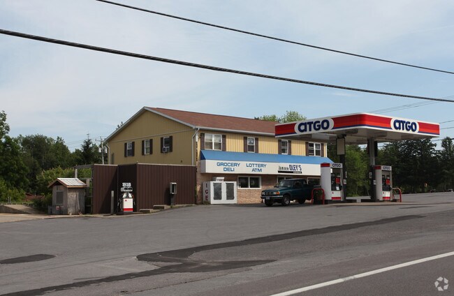
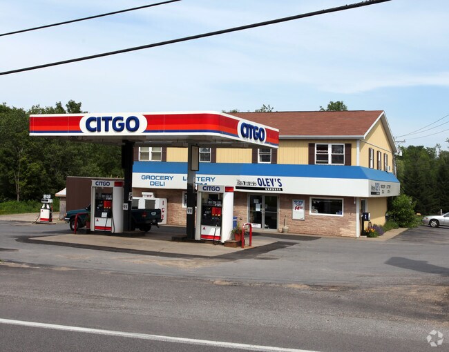
Property Detail
7681 State Route 104
Syracuse, NY
Oswego
354200-163-000-0001-006-000-0000
New York
Servicestationmarket
1.03 AC
01 - NOT Z
Oswego County
B and X Area of moderate flood hazard, usually the area between the limits of the 100-year and 500-year floods.
Syracuse
4,032 SF
NEARBY LISTINGS FOR SALE OR LEASE
-
-
View all Oswego listings for sale on LoopNet.com
DEMOGRAPHICS near 7681 State Route 104
1 mile
3 mile
5 mile
2025 Total Population
989
7,988
23,483
2030 Population
1,018
8,146
23,585
Pop Growth 2025-2030
+ 2.93%
+ 1.98%
+ 0.43%
Average Age
38
32
38
2025 Total Households
291
1,600
8,123
HH Growth 2025-2030
+ 3.09%
+ 2.13%
+ 0.10%
Median Household Inc
$109,198
$89,784
$64,766
Avg Household Size
2.40
2.40
2.20
2025 Avg HH Vehicles
2.00
2.00
2.00
Median Home Value
$197,618
$180,196
$154,059
Median Year Built
1978
1976
1957
Nearby Places
Map Layers
Map Styles
 Street
 Aerial
Layers
 Traffic
 Biking
Places
Listings with unknown addresses are not visible on the map
- Restaurants
- Banks
- Shops
- Fitness
- Groceries
PUBLIC TRANSPORTATION
AIRPORT
Syracuse Hancock International
Drive
Walk
Distance
Syracuse Hancock International
55 min
39.0 mi
Nearby Properties
Address
Land Use
TOTAL SIZE
Lot Size
Zoning
Address
Land Use
TOTAL SIZE
Lot Size
Zoning
7,056 SF
6.51 AC
01
Address
Land Use
TOTAL SIZE
Lot Size
Zoning
3,892 SF
23.65 AC
04 - FARM
Address
Land Use
TOTAL SIZE
Lot Size
Zoning
27,270 SF
23.22 AC
01 - NOT Z
Address
Land Use
TOTAL SIZE
Lot Size
Zoning
17,016 SF
11.59 AC
01 - NOT Z
Address
Land Use
TOTAL SIZE
Lot Size
Zoning
11,735 SF
7.38 AC
01 - NOT Z
Address
Land Use
TOTAL SIZE
Lot Size
Zoning
17,834 SF
154.65 AC
01 - NOT Z
Address
Land Use
TOTAL SIZE
Lot Size
Zoning
48,023 SF
16.93 AC
01 - NOT Z
Address
Land Use
TOTAL SIZE
Lot Size
Zoning
9,191 SF
1.81 AC
Address
Land Use
TOTAL SIZE
Lot Size
Zoning
5,740 SF
0.65 AC
01 - NOT Z
Address
Land Use
TOTAL SIZE
Lot Size
Zoning
9,012 SF
4.19 AC
01 - NOT Z
Address
Land Use
TOTAL SIZE
Lot Size
Zoning
8,224 SF
7.72 AC
01 - NOT Z
Address
Land Use
TOTAL SIZE
Lot Size
Zoning
11,053 SF
17.29 AC
01 - NOT Z
Address
Land Use
TOTAL SIZE
Lot Size
Zoning
187.20 AC
01 - NOT Z
Address
Land Use
TOTAL SIZE
Lot Size
Zoning
3,600 SF
1.44 AC
TN2
Address
Land Use
TOTAL SIZE
Lot Size
Zoning
4,652 SF
1.15 AC
01 - NOT Z
Address
Land Use
TOTAL SIZE
Lot Size
Zoning
236.43 AC
01 - NOT Z
Address
Land Use
TOTAL SIZE
Lot Size
Zoning
780 SF
10.22 AC
02 - SINGL
Address
Land Use
TOTAL SIZE
Lot Size
Zoning
24.97 AC
03 - MULTI
Address
Land Use
TOTAL SIZE
Lot Size
Zoning
880 SF
44.23 AC
01 - NOT Z
Address
Land Use
TOTAL SIZE
Lot Size
Zoning
7,344 SF
5 AC
01 - NOT Z
Address
Land Use
TOTAL SIZE
Lot Size
Zoning
1,992 SF
5.50 AC
01 - NOT Z
Address
Land Use
TOTAL SIZE
Lot Size
Zoning
4,128 SF
143.64 AC
01 - NOT Z
Address
Land Use
TOTAL SIZE
Lot Size
Zoning
9,431 SF
0.86 AC
01 - NOT Z
Address
Land Use
TOTAL SIZE
Lot Size
Zoning
8.93 AC
Address
Land Use
TOTAL SIZE
Lot Size
Zoning
8,386 SF
3.89 AC
01 - NOT Z
Address
Land Use
TOTAL SIZE
Lot Size
Zoning
11.56 AC
Address
Land Use
TOTAL SIZE
Lot Size
Zoning
5,184 SF
33.02 AC
01 - NOT Z
Address
Land Use
TOTAL SIZE
Lot Size
Zoning
3,908 SF
3.17 AC
01 - NOT Z
Address
Land Use
TOTAL SIZE
Lot Size
Zoning
1,600 SF
9.31 AC
03 - MULTI
Address
Land Use
TOTAL SIZE
Lot Size
Zoning
5,200 SF
12.29 AC
01 - NOT Z
The World's #1 Commercial Real Estate Marketplace
Connect with us
© 2026 CoStar Group
The information above has been obtained from sources believed reliable. While we do not doubt its accuracy we have not verified it and make no guarantee, warranty or representation about it. It is your responsibility to independently confirm its accuracy and completeness. Any projections, opinions, assumptions, or estimates used are for example only and do not represent the current or future performance of the property. The value of this transaction to you depends on tax and other factors which should be evaluated by your tax, financial, and legal advisors. You and your advisors should conduct a careful, independent investigation of the property to determine to your satisfaction the suitability of the property for your needs.