Property Record
7685 E Tanque Verde Rd, Tucson, AZ 85715
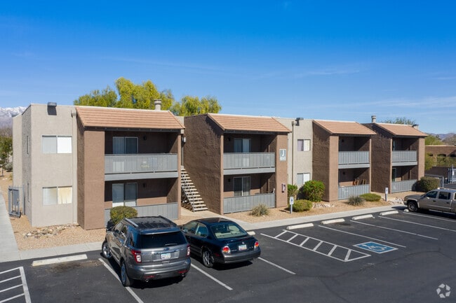
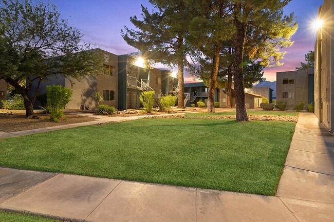
Property Detail
7685 E Tanque Verde Rd
Tucson, AZ
PTN E399.95 W429.95 E2 SE4 SW4 LYG N & ADJ RD 6.47 AC SEC 32-13-15
114-46-027J
PIMA
Apartment
Arizona
O3
139
2025
8.10 AC
2026
Ward 2
004031
Tucson
168,084 SF
NEARBY LISTINGS FOR SALE OR LEASE
-
-
View all Tucson listings for sale on LoopNet.com
DEMOGRAPHICS near 7685 E Tanque Verde Rd
1 mile
3 mile
5 mile
2025 Total Population
9,604
84,703
221,173
2030 Population
9,773
86,762
226,146
Pop Growth 2025-2030
+ 1.76%
+ 2.43%
+ 2.25%
Average Age
46
45
43
2025 Total Households
4,717
41,578
101,706
HH Growth 2025-2030
+ 1.82%
+ 2.55%
+ 2.41%
Median Household Inc
$80,686
$65,684
$66,485
Avg Household Size
2.00
2.00
2.10
2025 Avg HH Vehicles
2.00
2.00
2.00
Median Home Value
$390,020
$367,949
$347,432
Median Year Built
1984
1979
1977
Nearby Places
Map Layers
Map Styles
 Street
 Aerial
Transit
 Traffic
 Biking
Places
Listings with unknown addresses are not visible on the map
- Restaurants
- Banks
- Shops
- Fitness
- Groceries
PUBLIC TRANSPORTATION
AIRPORT
Tucson International
Drive
Walk
Distance
Tucson International
28 min
15.6 mi
Freight Ports
Port of San Diego
Drive
Walk
Distance
Port of San Diego
450 min
416.0 mi
Nearby Properties
Address
Land Use
TOTAL SIZE
Lot Size
Zoning
Address
Land Use
TOTAL SIZE
Lot Size
Zoning
1,089,840 SF
45.56 AC
Address
Land Use
TOTAL SIZE
Lot Size
Zoning
53,431 SF
9.98 AC
Address
Land Use
TOTAL SIZE
Lot Size
Zoning
684,356 SF
19.65 AC
PAD13
Address
Land Use
TOTAL SIZE
Lot Size
Zoning
96,125 SF
15.38 AC
SR
Address
Land Use
TOTAL SIZE
Lot Size
Zoning
308,730 SF
10.15 AC
Address
Land Use
TOTAL SIZE
Lot Size
Zoning
504,584 SF
18.17 AC
O3
Address
Land Use
TOTAL SIZE
Lot Size
Zoning
427,088 SF
19.78 AC
R3
Address
Land Use
TOTAL SIZE
Lot Size
Zoning
310,878 SF
29.30 AC
TR
Address
Land Use
TOTAL SIZE
Lot Size
Zoning
256,775 SF
6.69 AC
C1
Address
Land Use
TOTAL SIZE
Lot Size
Zoning
322,009 SF
17.96 AC
Address
Land Use
TOTAL SIZE
Lot Size
Zoning
364,128 SF
11.55 AC
O3
Address
Land Use
TOTAL SIZE
Lot Size
Zoning
109,335 SF
7.83 AC
PAD13
Address
Land Use
TOTAL SIZE
Lot Size
Zoning
1,804 SF
8.29 AC
R3
Address
Land Use
TOTAL SIZE
Lot Size
Zoning
230,640 SF
11.99 AC
Address
Land Use
TOTAL SIZE
Lot Size
Zoning
276,903 SF
37.62 AC
RX1
Address
Land Use
TOTAL SIZE
Lot Size
Zoning
240,585 SF
18.16 AC
R2
Address
Land Use
TOTAL SIZE
Lot Size
Zoning
264,788 SF
12.63 AC
R3
Address
Land Use
TOTAL SIZE
Lot Size
Zoning
74,815 SF
5.05 AC
Address
Land Use
TOTAL SIZE
Lot Size
Zoning
162,630 SF
15.14 AC
Address
Land Use
TOTAL SIZE
Lot Size
Zoning
180,149 SF
17.48 AC
PAD3
Address
Land Use
TOTAL SIZE
Lot Size
Zoning
288,749 SF
21.55 AC
CR2
Address
Land Use
TOTAL SIZE
Lot Size
Zoning
286,164 SF
5.80 AC
C3
Address
Land Use
TOTAL SIZE
Lot Size
Zoning
238,953 SF
14.13 AC
CB1
Address
Land Use
TOTAL SIZE
Lot Size
Zoning
118,655 SF
8.74 AC
C1
Address
Land Use
TOTAL SIZE
Lot Size
Zoning
240,309 SF
14.71 AC
CB1
Address
Land Use
TOTAL SIZE
Lot Size
Zoning
268,026 SF
16 AC
R3
Address
Land Use
TOTAL SIZE
Lot Size
Zoning
160,678 SF
16.12 AC
Address
Land Use
TOTAL SIZE
Lot Size
Zoning
171,301 SF
6.36 AC
C3
Address
Land Use
TOTAL SIZE
Lot Size
Zoning
146,302 SF
27.52 AC
CR1
Address
Land Use
TOTAL SIZE
Lot Size
Zoning
84,514 SF
4.77 AC
The World's #1 Commercial Real Estate Marketplace
Connect with us
© 2026 CoStar Group
The information above has been obtained from sources believed reliable. While we do not doubt its accuracy we have not verified it and make no guarantee, warranty or representation about it. It is your responsibility to independently confirm its accuracy and completeness. Any projections, opinions, assumptions, or estimates used are for example only and do not represent the current or future performance of the property. The value of this transaction to you depends on tax and other factors which should be evaluated by your tax, financial, and legal advisors. You and your advisors should conduct a careful, independent investigation of the property to determine to your satisfaction the suitability of the property for your needs.