Property Record
7686 Georgetown Center Dr, Jenison, MI 49428
NEARBY LISTINGS FOR SALE OR LEASE
Property Detail
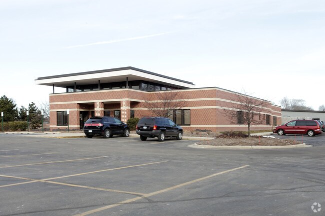
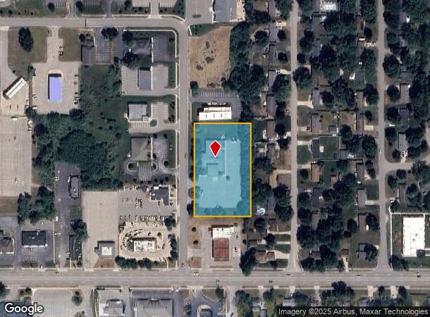
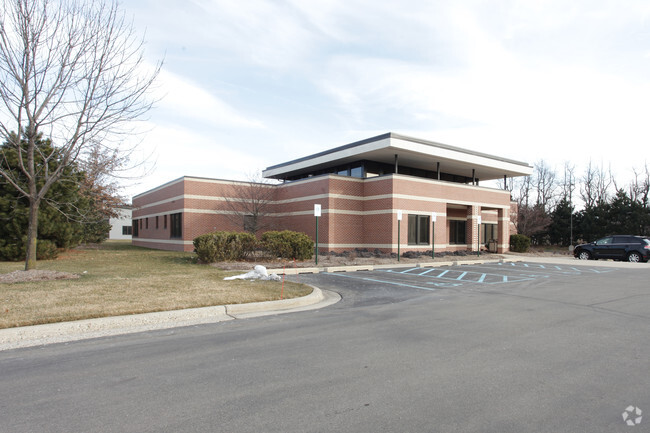
7686 Georgetown Center Dr
Grand Rapids-Wyoming, MI
Jenison Village Square
70-14-15-227-013
LOTS 1 & 2 JENISON VILLAGE SQUARE
Medicalbuilding
Ottawa
X
Michigan
26081C0400D
1-2
2024
1.99 AC
2025
E Ottawa Cnty/Hudsonville
021606
West Michigan
10,267 SF
DEMOGRAPHICS near 7686 Georgetown Center Dr
1 Mile
3 Mile
5 Mile
2024 Total Population
9,174
47,993
99,641
2029 Population
9,551
50,239
103,644
Pop Growth 2024-2029
+ 4.11%
+ 4.68%
+ 4.02%
Average Age
40
39
38
2024 Total Households
3,344
17,249
35,614
HH Growth 2024-2029
+ 4.31%
+ 4.78%
+ 4.03%
Median Household Inc
$82,174
$85,421
$84,964
Avg Household Size
2.70
2.70
2.70
2024 Avg HH Vehicles
2.00
2.00
2.00
Median Home Value
$225,529
$260,502
$268,068
Median Year Built
1971
1981
1985
Nearby Places
Map Layers
Map Styles
 Street
 Aerial
- Restaurants
- Banks
- Shops
- Fitness
- Groceries
PUBLIC TRANSPORTATION
COMMUTER RAIL
Grand Rapids Vernon J. Ehlers Station (Pere Marquette - Amtrak)
DRIVE
WALK
Distance
Grand Rapids Vernon J. Ehlers Station (Pere Marquette - Amtrak)
15 min
9.5 mi
AIRPORT
Gerald R Ford International
DRIVE
WALK
Distance
Gerald R Ford International
34 min
18.2 mi
Freight Ports
Port Milwaukee
DRIVE
WALK
Distance
Port Milwaukee
299 min
253.7 mi
Nearby Properties
Address
Land Use
TOTAL SIZE
Lot Size
Zoning
Address
Land Use
TOTAL SIZE
Lot Size
Zoning
268,440 SF
28.11 AC
HDR
Address
Land Use
TOTAL SIZE
Lot Size
Zoning
20.61 AC
HDR
Address
Land Use
TOTAL SIZE
Lot Size
Zoning
269,021 SF
22.89 AC
HDR
Address
Land Use
TOTAL SIZE
Lot Size
Zoning
173,288 SF
4.17 AC
PUD
Address
Land Use
TOTAL SIZE
Lot Size
Zoning
114,312 SF
22.23 AC
R-4
Address
Land Use
TOTAL SIZE
Lot Size
Zoning
222,785 SF
26.69 AC
CS
Address
Land Use
TOTAL SIZE
Lot Size
Zoning
124,950 SF
18.30 AC
MHR
Address
Land Use
TOTAL SIZE
Lot Size
Zoning
66,766 SF
R-1-A
Address
Land Use
TOTAL SIZE
Lot Size
Zoning
139,774 SF
10.67 AC
HDR-B
Address
Land Use
TOTAL SIZE
Lot Size
Zoning
82,554 SF
5.56 AC
HDR
Address
Land Use
TOTAL SIZE
Lot Size
Zoning
6.77 AC
R3-B
Address
Land Use
TOTAL SIZE
Lot Size
Zoning
71,102 SF
8.65 AC
MHR
Address
Land Use
TOTAL SIZE
Lot Size
Zoning
45,636 SF
14.11 AC
C-5
Address
Land Use
TOTAL SIZE
Lot Size
Zoning
106,193 SF
10.68 AC
CS
Address
Land Use
TOTAL SIZE
Lot Size
Zoning
8,448 SF
2.68 AC
R-4
Address
Land Use
TOTAL SIZE
Lot Size
Zoning
59,018 SF
10.60 AC
HDR
Address
Land Use
TOTAL SIZE
Lot Size
Zoning
66,980 SF
LDR
Address
Land Use
TOTAL SIZE
Lot Size
Zoning
44,400 SF
6.69 AC
HS
Address
Land Use
TOTAL SIZE
Lot Size
Zoning
16,816 SF
3.33 AC
NS
Address
Land Use
TOTAL SIZE
Lot Size
Zoning
90,900 SF
8.53 AC
CS
Address
Land Use
TOTAL SIZE
Lot Size
Zoning
94,894 SF
7.35 AC
I
Address
Land Use
TOTAL SIZE
Lot Size
Zoning
5,054 SF
3.86 AC
LDR
Address
Land Use
TOTAL SIZE
Lot Size
Zoning
39,306 SF
3.65 AC
I
Address
Land Use
TOTAL SIZE
Lot Size
Zoning
174,484 SF
10.50 AC
I-2
Address
Land Use
TOTAL SIZE
Lot Size
Zoning
47,632 SF
4 AC
CS
Address
Land Use
TOTAL SIZE
Lot Size
Zoning
Address
Land Use
TOTAL SIZE
Lot Size
Zoning
33,530 SF
3.84 AC
HDR
Address
Land Use
TOTAL SIZE
Lot Size
Zoning
10,000 SF
2.02 AC
OS
Address
Land Use
TOTAL SIZE
Lot Size
Zoning
38,588 SF
3.14 AC
CS
Address
Land Use
TOTAL SIZE
Lot Size
Zoning
52,856 SF
3.94 AC
I
The World's #1 Commercial Real Estate Marketplace
Connect with us
© 2026 CoStar Group
The information above has been obtained from sources believed reliable. While we do not doubt its accuracy we have not verified it and make no guarantee, warranty or representation about it. It is your responsibility to independently confirm its accuracy and completeness. Any projections, opinions, assumptions, or estimates used are for example only and do not represent the current or future performance of the property. The value of this transaction to you depends on tax and other factors which should be evaluated by your tax, financial, and legal advisors. You and your advisors should conduct a careful, independent investigation of the property to determine to your satisfaction the suitability of the property for your needs.