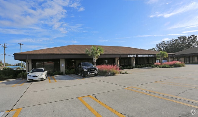
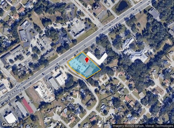
Property Record
769 Blanding Blvd, Orange Park, FL 32065
Current Lease Availabilities
NEARBY LISTINGS FOR SALE OR LEASE
Property Detail
769 Blanding Blvd
Jacksonville, FL
The Meadows
24-04-25-020404-117-01
PT TRACT A THE MEADOWS AS REC OR 644 PG 623; 748 PG 216 & 1447 PG 680
Regionalshoppingcenterormallwithanchorstore
Clay
X
Florida
12019C0070E
a
2024
1.45 AC
2025
Orange Park/Clay County
030802
Jacksonville (Florida)
10,919 SF
DEMOGRAPHICS near 769 Blanding Blvd
1 Mile
3 Mile
5 Mile
2024 Total Population
9,240
50,199
146,089
2029 Population
10,006
54,446
157,605
Pop Growth 2024-2029
+ 8.29%
+ 8.46%
+ 7.88%
Average Age
44
42
40
2024 Total Households
3,499
18,732
54,023
HH Growth 2024-2029
+ 8.40%
+ 8.53%
+ 7.94%
Median Household Inc
$75,323
$77,714
$77,976
Avg Household Size
2.60
2.60
2.60
2024 Avg HH Vehicles
2.00
2.00
2.00
Median Home Value
$228,829
$240,540
$246,603
Median Year Built
1983
1983
1992
Nearby Places
- Restaurants
- Banks
- Shops
- Fitness
- Groceries
PUBLIC TRANSPORTATION
AIRPORT
Jacksonville International
DRIVE
WALK
Distance
Jacksonville International
43 min
30.0 mi
Freight Ports
Jacksonville Port
DRIVE
WALK
Distance
Jacksonville Port
37 min
23.8 mi
Nearby Properties
Address
Land Use
TOTAL SIZE
Lot Size
Zoning
Address
Land Use
TOTAL SIZE
Lot Size
Zoning
446,722 SF
13.26 AC
PUD
Address
Land Use
TOTAL SIZE
Lot Size
Zoning
238,713 SF
53.48 AC
BB
Address
Land Use
TOTAL SIZE
Lot Size
Zoning
281,440 SF
17.01 AC
Address
Land Use
TOTAL SIZE
Lot Size
Zoning
233,551 SF
18.96 AC
PUD
Address
Land Use
TOTAL SIZE
Lot Size
Zoning
234,646 SF
18.97 AC
Address
Land Use
TOTAL SIZE
Lot Size
Zoning
148,895 SF
35.72 AC
PO-1
Address
Land Use
TOTAL SIZE
Lot Size
Zoning
92,193 SF
20.65 AC
PUD
Address
Land Use
TOTAL SIZE
Lot Size
Zoning
207,472 SF
13.39 AC
RD-4
Address
Land Use
TOTAL SIZE
Lot Size
Zoning
172,568 SF
13.15 AC
Address
Land Use
TOTAL SIZE
Lot Size
Zoning
141,441 SF
82.05 AC
Address
Land Use
TOTAL SIZE
Lot Size
Zoning
98,675 SF
24.30 AC
Address
Land Use
TOTAL SIZE
Lot Size
Zoning
168,475 SF
9.38 AC
RD-4
Address
Land Use
TOTAL SIZE
Lot Size
Zoning
173,163 SF
18.32 AC
BSC
Address
Land Use
TOTAL SIZE
Lot Size
Zoning
137,153 SF
25.85 AC
Address
Land Use
TOTAL SIZE
Lot Size
Zoning
97,584 SF
3.54 AC
CN
Address
Land Use
TOTAL SIZE
Lot Size
Zoning
112,498 SF
40 AC
Address
Land Use
TOTAL SIZE
Lot Size
Zoning
120,529 SF
51.50 AC
Address
Land Use
TOTAL SIZE
Lot Size
Zoning
209,568 SF
24.51 AC
PCD
Address
Land Use
TOTAL SIZE
Lot Size
Zoning
120,581 SF
13.29 AC
Address
Land Use
TOTAL SIZE
Lot Size
Zoning
37,942 SF
5.58 AC
Address
Land Use
TOTAL SIZE
Lot Size
Zoning
140,280 SF
10.74 AC
Address
Land Use
TOTAL SIZE
Lot Size
Zoning
83,680 SF
7.86 AC
Address
Land Use
TOTAL SIZE
Lot Size
Zoning
70,693 SF
11.89 AC
Address
Land Use
TOTAL SIZE
Lot Size
Zoning
63,893 SF
5.99 AC
BB
Address
Land Use
TOTAL SIZE
Lot Size
Zoning
95,807 SF
9.91 AC
RS-2
Address
Land Use
TOTAL SIZE
Lot Size
Zoning
67,862 SF
58 AC
Address
Land Use
TOTAL SIZE
Lot Size
Zoning
114,583 SF
14.83 AC
Address
Land Use
TOTAL SIZE
Lot Size
Zoning
105,513 SF
3.25 AC
Address
Land Use
TOTAL SIZE
Lot Size
Zoning
97,563 SF
30 AC
GU
Address
Land Use
TOTAL SIZE
Lot Size
Zoning
49,712 SF
14.29 AC
PS-1
The World's #1 Commercial Real Estate Marketplace
Connect with us
© 2025 CoStar Group
The information above has been obtained from sources believed reliable. While we do not doubt its accuracy we have not verified it and make no guarantee, warranty or representation about it. It is your responsibility to independently confirm its accuracy and completeness. Any projections, opinions, assumptions, or estimates used are for example only and do not represent the current or future performance of the property. The value of this transaction to you depends on tax and other factors which should be evaluated by your tax, financial, and legal advisors. You and your advisors should conduct a careful, independent investigation of the property to determine to your satisfaction the suitability of the property for your needs.