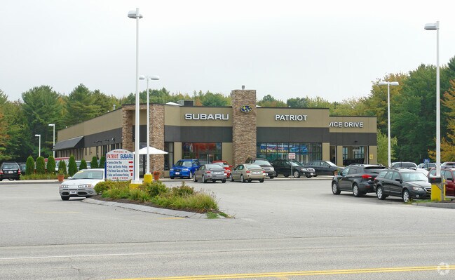
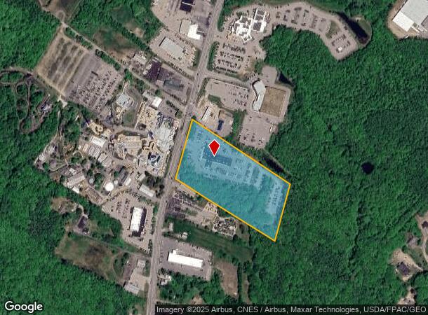
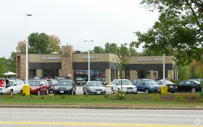
Property Record
769 Portland Rd, Saco, ME 04072
NEARBY LISTINGS FOR SALE OR LEASE
Property Detail
769 Portland Rd
SACO-000044-000007
York
Autorepair
Maine
X
7
23031C0452G
9.98 AC
2024
York County
2024
Portland/South Portland
005200
Portland-South Portland, ME
19,220 SF
DEMOGRAPHICS near 769 Portland Rd
1 Mile
3 Mile
5 Mile
2024 Total Population
693
34,751
57,278
2029 Population
725
37,107
60,795
Pop Growth 2024-2029
+ 4.62%
+ 6.78%
+ 6.14%
Average Age
44
43
43
2024 Total Households
305
16,323
25,686
HH Growth 2024-2029
+ 4.59%
+ 6.90%
+ 6.36%
Median Household Inc
$72,899
$58,892
$67,435
Avg Household Size
2.20
2.00
2.10
2024 Avg HH Vehicles
2.00
2.00
2.00
Median Home Value
$318,421
$315,511
$338,580
Median Year Built
1984
1980
1978
Nearby Places
Map Layers
Map Styles
 Street
 Aerial
- Restaurants
- Banks
- Shops
- Fitness
- Groceries
PUBLIC TRANSPORTATION
COMMUTER RAIL
Saco Amtrak Station (Downeaster - Amtrak)
DRIVE
WALK
Distance
Saco Amtrak Station (Downeaster - Amtrak)
7 min
2.8 mi
Old Orchard Beach Amtrak (Downeaster - Amtrak)
DRIVE
WALK
Distance
Old Orchard Beach Amtrak (Downeaster - Amtrak)
9 min
4.6 mi
AIRPORT
Portland International Jetport
DRIVE
WALK
Distance
Portland International Jetport
22 min
14.4 mi
Freight Ports
Portland, ME
DRIVE
WALK
Distance
Portland, ME
23 min
17.0 mi
Nearby Properties
Address
Land Use
TOTAL SIZE
Lot Size
Zoning
Address
Land Use
TOTAL SIZE
Lot Size
Zoning
10 AC
B-4
Address
Land Use
TOTAL SIZE
Lot Size
Zoning
233,280 SF
8.40 AC
MSRD3
Address
Land Use
TOTAL SIZE
Lot Size
Zoning
230,822 SF
3.50 AC
MSRD3
Address
Land Use
TOTAL SIZE
Lot Size
Zoning
141.57 AC
I-1
Address
Land Use
TOTAL SIZE
Lot Size
Zoning
Address
Land Use
TOTAL SIZE
Lot Size
Zoning
224,607 SF
5.07 AC
B-4
Address
Land Use
TOTAL SIZE
Lot Size
Zoning
122,465 SF
0.51 AC
MSRD3
Address
Land Use
TOTAL SIZE
Lot Size
Zoning
27.50 AC
R-1B
Address
Land Use
TOTAL SIZE
Lot Size
Zoning
2,295.68 AC
B-6
Address
Land Use
TOTAL SIZE
Lot Size
Zoning
136,348 SF
1.57 AC
MSRD3
Address
Land Use
TOTAL SIZE
Lot Size
Zoning
7.86 AC
B2A
Address
Land Use
TOTAL SIZE
Lot Size
Zoning
2,637 SF
81.33 AC
MZ
Address
Land Use
TOTAL SIZE
Lot Size
Zoning
Address
Land Use
TOTAL SIZE
Lot Size
Zoning
2.50 AC
R-1
Address
Land Use
TOTAL SIZE
Lot Size
Zoning
Address
Land Use
TOTAL SIZE
Lot Size
Zoning
11.40 AC
B-1
Address
Land Use
TOTAL SIZE
Lot Size
Zoning
708 SF
52.01 AC
R-4
Address
Land Use
TOTAL SIZE
Lot Size
Zoning
62,610 SF
2.61 AC
R-1A
Address
Land Use
TOTAL SIZE
Lot Size
Zoning
110 AC
R-1D
Address
Land Use
TOTAL SIZE
Lot Size
Zoning
52,582 SF
12.58 AC
B-6
Address
Land Use
TOTAL SIZE
Lot Size
Zoning
75,382 SF
0.85 AC
MSRD3
Address
Land Use
TOTAL SIZE
Lot Size
Zoning
3,033 SF
55.01 AC
RD
Address
Land Use
TOTAL SIZE
Lot Size
Zoning
49,518 SF
5.60 AC
R-1A
Address
Land Use
TOTAL SIZE
Lot Size
Zoning
108,730 SF
0.52 AC
MSRD3
Address
Land Use
TOTAL SIZE
Lot Size
Zoning
35,714 SF
39.79 AC
MU3
Address
Land Use
TOTAL SIZE
Lot Size
Zoning
63,300 SF
11.76 AC
B-2D
Address
Land Use
TOTAL SIZE
Lot Size
Zoning
124,800 SF
30.53 AC
Address
Land Use
TOTAL SIZE
Lot Size
Zoning
89,540 SF
0.44 AC
MSRD3
Address
Land Use
TOTAL SIZE
Lot Size
Zoning
104.72 AC
B-6
Address
Land Use
TOTAL SIZE
Lot Size
Zoning
4,296 SF
27.94 AC
MZ
The World's #1 Commercial Real Estate Marketplace
Connect with us
© 2026 CoStar Group
The information above has been obtained from sources believed reliable. While we do not doubt its accuracy we have not verified it and make no guarantee, warranty or representation about it. It is your responsibility to independently confirm its accuracy and completeness. Any projections, opinions, assumptions, or estimates used are for example only and do not represent the current or future performance of the property. The value of this transaction to you depends on tax and other factors which should be evaluated by your tax, financial, and legal advisors. You and your advisors should conduct a careful, independent investigation of the property to determine to your satisfaction the suitability of the property for your needs.