Property Record
7691 Bradshaw Rd, Sacramento, CA 95829

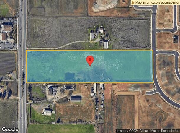
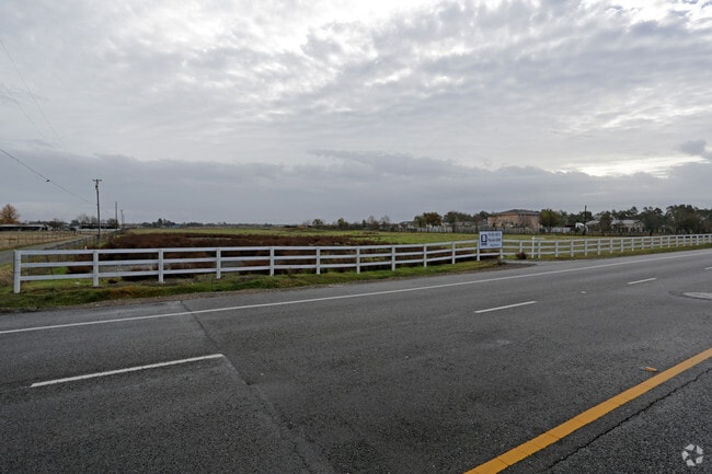

This Property Is For Sale
NEARBY LISTINGS FOR SALE OR LEASE
Property Detail
7691 Bradshaw Rd
122-0010-011
PCL B OF PM39-9 EXCL R/W PER 20080428-821
Recreationalacreage
Sacramento
AO
California
06067C0327H
b
2024
9.79 AC
2025
South Sacramento
009330
Sacramento
2,172 SF
Sacramento--Roseville--Arden-Arcade, CA
DEMOGRAPHICS near 7691 Bradshaw Rd
1 Mile
3 Mile
5 Mile
2024 Total Population
5,375
53,821
157,870
2029 Population
5,487
54,089
158,444
Pop Growth 2024-2029
+ 2.08%
+ 0.50%
+ 0.36%
Average Age
38
38
38
2024 Total Households
1,612
15,883
47,766
HH Growth 2024-2029
+ 2.11%
+ 0.44%
+ 0.34%
Median Household Inc
$118,262
$102,027
$89,189
Avg Household Size
3.30
3.30
3.20
2024 Avg HH Vehicles
2.00
2.00
2.00
Median Home Value
$538,546
$478,007
$466,732
Median Year Built
2010
1997
1992
Nearby Places
Map Layers
Map Styles
 Street
 Aerial
- Restaurants
- Banks
- Shops
- Fitness
- Groceries
PUBLIC TRANSPORTATION
AIRPORT
Sacramento International
DRIVE
WALK
Distance
Sacramento International
36 min
25.4 mi
Freight Ports
Port of Stockton
DRIVE
WALK
Distance
Port of Stockton
56 min
43.5 mi
Nearby Properties
Address
Land Use
TOTAL SIZE
Lot Size
Zoning
Address
Land Use
TOTAL SIZE
Lot Size
Zoning
204,290 SF
11.86 AC
RD-20
Address
Land Use
TOTAL SIZE
Lot Size
Zoning
161,834 SF
15.23 AC
LC
Address
Land Use
TOTAL SIZE
Lot Size
Zoning
167,152 SF
7.53 AC
RD-20
Address
Land Use
TOTAL SIZE
Lot Size
Zoning
90,925 SF
9.77 AC
AR-1
Address
Land Use
TOTAL SIZE
Lot Size
Zoning
112,007 SF
5.02 AC
RD-20
Address
Land Use
TOTAL SIZE
Lot Size
Zoning
55,143 SF
4.46 AC
SC
Address
Land Use
TOTAL SIZE
Lot Size
Zoning
17.32 AC
RD-7 RD-10
Address
Land Use
TOTAL SIZE
Lot Size
Zoning
108,941 SF
4.31 AC
RD-20
Address
Land Use
TOTAL SIZE
Lot Size
Zoning
49,900 SF
6.16 AC
RD-20
Address
Land Use
TOTAL SIZE
Lot Size
Zoning
11.09 AC
RD-5
Address
Land Use
TOTAL SIZE
Lot Size
Zoning
82,530 SF
3.56 AC
MP
Address
Land Use
TOTAL SIZE
Lot Size
Zoning
RD-5 O RD-
Address
Land Use
TOTAL SIZE
Lot Size
Zoning
22.42 AC
RD-5
Address
Land Use
TOTAL SIZE
Lot Size
Zoning
56,435 SF
4.89 AC
GC
Address
Land Use
TOTAL SIZE
Lot Size
Zoning
7.13 AC
SC
Address
Land Use
TOTAL SIZE
Lot Size
Zoning
36.41 AC
RD-5 RD-7
Address
Land Use
TOTAL SIZE
Lot Size
Zoning
72,925 SF
3.38 AC
MP
Address
Land Use
TOTAL SIZE
Lot Size
Zoning
2,256 SF
4.64 AC
PS
Address
Land Use
TOTAL SIZE
Lot Size
Zoning
12,900 SF
1.70 AC
GC
Address
Land Use
TOTAL SIZE
Lot Size
Zoning
2,993 SF
6.57 AC
AR-5
Address
Land Use
TOTAL SIZE
Lot Size
Zoning
14,423 SF
9.60 AC
AR-10
Address
Land Use
TOTAL SIZE
Lot Size
Zoning
39.69 AC
RD-3 RD-5
Address
Land Use
TOTAL SIZE
Lot Size
Zoning
5,000 SF
161.69 AC
AG-80
Address
Land Use
TOTAL SIZE
Lot Size
Zoning
11,010 SF
0.96 AC
SC
Address
Land Use
TOTAL SIZE
Lot Size
Zoning
14,905 SF
1.90 AC
SC
Address
Land Use
TOTAL SIZE
Lot Size
Zoning
26,385 SF
2.33 AC
SC
Address
Land Use
TOTAL SIZE
Lot Size
Zoning
11,392 SF
0.83 AC
GC
Address
Land Use
TOTAL SIZE
Lot Size
Zoning
36,270 SF
15.88 AC
M-1
Address
Land Use
TOTAL SIZE
Lot Size
Zoning
2,399 SF
2.34 AC
LC
Address
Land Use
TOTAL SIZE
Lot Size
Zoning
720 SF
38.04 AC
AR-10
The World's #1 Commercial Real Estate Marketplace
Connect with us
© 2025 CoStar Group
The information above has been obtained from sources believed reliable. While we do not doubt its accuracy we have not verified it and make no guarantee, warranty or representation about it. It is your responsibility to independently confirm its accuracy and completeness. Any projections, opinions, assumptions, or estimates used are for example only and do not represent the current or future performance of the property. The value of this transaction to you depends on tax and other factors which should be evaluated by your tax, financial, and legal advisors. You and your advisors should conduct a careful, independent investigation of the property to determine to your satisfaction the suitability of the property for your needs.