Property Record
76Th St, Salem, WI 53168

Save to a Folder
{{folder.Name}}
{{folder.ListingIds.length}} Properties
{{folder.ListingIds.length}} Property
Create a New Folder
Property Detail
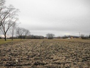
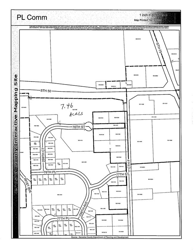
76Th St
Kenosha, WI
LOT 86 EXC WLY 419.01 FT WHITETAIL RIDGE SUB PLAT# 7755 DOC# 1536120 ALSO INC N'RLY ROW OF VACATED PORTION OF 76TH ST PER RES
40-4-120-102-1186
KENOSHA
Agriculturalland
Wisconsin
B and X Area of moderate flood hazard, usually the area between the limits of the 100-year and 500-year floods.
86
2025
5 AC
2025
Kenosha West
002903
Chicago
NEARBY LISTINGS FOR SALE OR LEASE
-
-
No Photo
-
View all Salem listings for sale on LoopNet.com
DEMOGRAPHICS near 76Th St
1 mile
3 mile
5 mile
2025 Total Population
1,831
11,965
23,459
2030 Population
1,856
12,146
23,697
Pop Growth 2025-2030
+ 1.37%
+ 1.51%
+ 1.01%
Average Age
41
42
42
2025 Total Households
725
4,710
9,139
HH Growth 2025-2030
+ 1.24%
+ 1.44%
+ 0.96%
Median Household Inc
$96,353
$94,138
$95,197
Avg Household Size
2.50
2.50
2.60
2025 Avg HH Vehicles
2.00
2.00
2.00
Median Home Value
$248,156
$286,251
$288,425
Median Year Built
1974
1981
1979
Nearby Places
Map Layers
Map Styles
 Street
 Aerial
Layers
 Traffic
 Biking
Places
Listings with unknown addresses are not visible on the map
- Restaurants
- Banks
- Shops
- Fitness
- Groceries
PUBLIC TRANSPORTATION
COMMUTER RAIL
Antioch Station (North Central Service - Northeast Illinois Regional Commuter Railroad (Metra))
Drive
Walk
Distance
Antioch Station (North Central Service - Northeast Illinois Regional Commuter Railroad (Metra))
11 min
6.7 mi
AIRPORT
General Mitchell International
Drive
Walk
Distance
General Mitchell International
46 min
36.7 mi
Freight Ports
Port Milwaukee
Drive
Walk
Distance
Port Milwaukee
51 min
40.6 mi
Nearby Properties
Address
Land Use
TOTAL SIZE
Lot Size
Zoning
Address
Land Use
TOTAL SIZE
Lot Size
Zoning
11,000 SF
6.52 AC
Address
Land Use
TOTAL SIZE
Lot Size
Zoning
31,392 SF
3 AC
Address
Land Use
TOTAL SIZE
Lot Size
Zoning
22,984 SF
2.74 AC
Address
Land Use
TOTAL SIZE
Lot Size
Zoning
9,471 SF
2.91 AC
Address
Land Use
TOTAL SIZE
Lot Size
Zoning
22,750 SF
2.42 AC
Address
Land Use
TOTAL SIZE
Lot Size
Zoning
22,750 SF
2.39 AC
Address
Land Use
TOTAL SIZE
Lot Size
Zoning
12,528 SF
8.32 AC
Address
Land Use
TOTAL SIZE
Lot Size
Zoning
11,500 SF
2.43 AC
Address
Land Use
TOTAL SIZE
Lot Size
Zoning
20,345 SF
3.54 AC
Address
Land Use
TOTAL SIZE
Lot Size
Zoning
4,268 SF
1.65 AC
Address
Land Use
TOTAL SIZE
Lot Size
Zoning
23,600 SF
5.19 AC
Address
Land Use
TOTAL SIZE
Lot Size
Zoning
15,048 SF
1.92 AC
Address
Land Use
TOTAL SIZE
Lot Size
Zoning
14,620 SF
1.60 AC
Address
Land Use
TOTAL SIZE
Lot Size
Zoning
14,620 SF
1.66 AC
Address
Land Use
TOTAL SIZE
Lot Size
Zoning
21,723 SF
6.37 AC
Address
Land Use
TOTAL SIZE
Lot Size
Zoning
3,310 SF
1.72 AC
Address
Land Use
TOTAL SIZE
Lot Size
Zoning
3,952 SF
4.64 AC
Address
Land Use
TOTAL SIZE
Lot Size
Zoning
10,142 SF
2.45 AC
Address
Land Use
TOTAL SIZE
Lot Size
Zoning
1,104 SF
6.98 AC
Address
Land Use
TOTAL SIZE
Lot Size
Zoning
1,288 SF
1.83 AC
Address
Land Use
TOTAL SIZE
Lot Size
Zoning
7,912 SF
1.63 AC
Address
Land Use
TOTAL SIZE
Lot Size
Zoning
2,985 SF
1 AC
Address
Land Use
TOTAL SIZE
Lot Size
Zoning
16,748 SF
1.01 AC
Address
Land Use
TOTAL SIZE
Lot Size
Zoning
4,865 SF
34.21 AC
Address
Land Use
TOTAL SIZE
Lot Size
Zoning
5,399 SF
1.03 AC
Address
Land Use
TOTAL SIZE
Lot Size
Zoning
9,189 SF
1.48 AC
Address
Land Use
TOTAL SIZE
Lot Size
Zoning
2,188 SF
0.79 AC
Address
Land Use
TOTAL SIZE
Lot Size
Zoning
11,160 SF
5.45 AC
Address
Land Use
TOTAL SIZE
Lot Size
Zoning
13,680 SF
1.10 AC
Address
Land Use
TOTAL SIZE
Lot Size
Zoning
6,189 SF
1.71 AC
The World's #1 Commercial Real Estate Marketplace
Connect with us
© 2026 CoStar Group
The information above has been obtained from sources believed reliable. While we do not doubt its accuracy we have not verified it and make no guarantee, warranty or representation about it. It is your responsibility to independently confirm its accuracy and completeness. Any projections, opinions, assumptions, or estimates used are for example only and do not represent the current or future performance of the property. The value of this transaction to you depends on tax and other factors which should be evaluated by your tax, financial, and legal advisors. You and your advisors should conduct a careful, independent investigation of the property to determine to your satisfaction the suitability of the property for your needs.