Property Record
77-6316 Mamalahoa Hwy, Holualoa, HI 96725
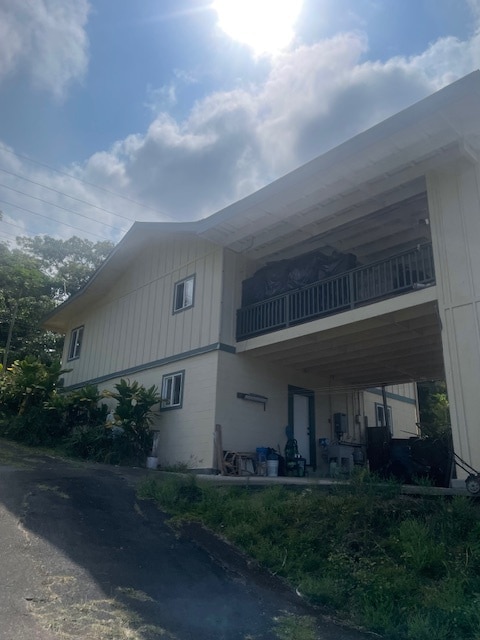
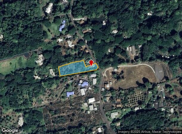
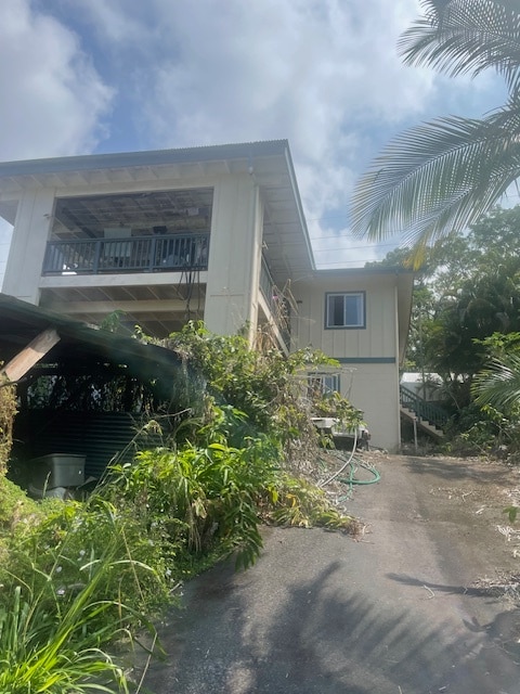
This Property Is For Sale
NEARBY LISTINGS FOR SALE OR LEASE
Property Detail
77-6316 Mamalahoa Hwy
Agriculturalland
Hawaii
X
Hawaii
1551660952F
1.18 AC
2024
Kailua Kona
2025
Hawaii
021511
Hilo, HI
2,548 SF
3-7-7-007-028-0000
DEMOGRAPHICS near 77-6316 Mamalahoa Hwy
1 Mile
3 Mile
5 Mile
2024 Total Population
1,540
16,792
29,683
2029 Population
1,710
19,390
34,146
Pop Growth 2024-2029
+ 11.04%
+ 15.47%
+ 15.04%
Average Age
48
47
46
2024 Total Households
564
6,484
11,559
HH Growth 2024-2029
+ 10.64%
+ 15.73%
+ 15.48%
Median Household Inc
$96,360
$87,761
$80,561
Avg Household Size
2.60
2.50
2.40
2024 Avg HH Vehicles
2.00
2.00
2.00
Median Home Value
$776,816
$794,782
$718,670
Median Year Built
1985
1987
1986
Nearby Places
- Restaurants
- Banks
- Shops
- Fitness
- Groceries
PUBLIC TRANSPORTATION
AIRPORT
Ellison Onizuka Kona International at Keahole
DRIVE
WALK
Distance
Ellison Onizuka Kona International at Keahole
28 min
13.5 mi
Nearby Properties
Address
Land Use
TOTAL SIZE
Lot Size
Zoning
Address
Land Use
TOTAL SIZE
Lot Size
Zoning
252,310 SF
14.86 AC
V-.75
Address
Land Use
TOTAL SIZE
Lot Size
Zoning
14,994 SF
2.55 AC
OPEN
Address
Land Use
TOTAL SIZE
Lot Size
Zoning
185,689 SF
21.22 AC
CV-7.5
Address
Land Use
TOTAL SIZE
Lot Size
Zoning
10.04 AC
V-1.25
Address
Land Use
TOTAL SIZE
Lot Size
Zoning
221,679 SF
10.83 AC
V-.75
Address
Land Use
TOTAL SIZE
Lot Size
Zoning
1,112 SF
25.24 AC
V-1.25
Address
Land Use
TOTAL SIZE
Lot Size
Zoning
89,870 SF
3.98 AC
A-5a
Address
Land Use
TOTAL SIZE
Lot Size
Zoning
5.33 AC
RS-15
Address
Land Use
TOTAL SIZE
Lot Size
Zoning
288.28 AC
A-5a
Address
Land Use
TOTAL SIZE
Lot Size
Zoning
18.99 AC
CV-10
Address
Land Use
TOTAL SIZE
Lot Size
Zoning
47,685 SF
3.90 AC
RM-3
Address
Land Use
TOTAL SIZE
Lot Size
Zoning
31,375 SF
3.73 AC
RM-3
Address
Land Use
TOTAL SIZE
Lot Size
Zoning
25,060 SF
3.80 AC
CV-10
Address
Land Use
TOTAL SIZE
Lot Size
Zoning
7,308 SF
5 AC
A-5a
Address
Land Use
TOTAL SIZE
Lot Size
Zoning
3.08 AC
RS-15
Address
Land Use
TOTAL SIZE
Lot Size
Zoning
2,632 SF
2.49 AC
V-2.25
Address
Land Use
TOTAL SIZE
Lot Size
Zoning
4.20 AC
RS-15
Address
Land Use
TOTAL SIZE
Lot Size
Zoning
7,717 SF
6 AC
A-5a
Address
Land Use
TOTAL SIZE
Lot Size
Zoning
11.57 AC
V-.75
Address
Land Use
TOTAL SIZE
Lot Size
Zoning
3,457 SF
30.33 AC
RM-3
Address
Land Use
TOTAL SIZE
Lot Size
Zoning
5,223 SF
2.38 AC
A-5a
Address
Land Use
TOTAL SIZE
Lot Size
Zoning
25,222 SF
2.25 AC
CN-10
Address
Land Use
TOTAL SIZE
Lot Size
Zoning
5,152 SF
2.95 AC
A-5a
Address
Land Use
TOTAL SIZE
Lot Size
Zoning
5,830 SF
1.85 AC
A-1a
Address
Land Use
TOTAL SIZE
Lot Size
Zoning
11.42 AC
RS-7.5
Address
Land Use
TOTAL SIZE
Lot Size
Zoning
7,293 SF
3 AC
FA-2a
Address
Land Use
TOTAL SIZE
Lot Size
Zoning
1,650 SF
V-2.25
Address
Land Use
TOTAL SIZE
Lot Size
Zoning
4,814 SF
5.36 AC
A-5a
The World's #1 Commercial Real Estate Marketplace
Connect with us
© 2025 CoStar Group
The information above has been obtained from sources believed reliable. While we do not doubt its accuracy we have not verified it and make no guarantee, warranty or representation about it. It is your responsibility to independently confirm its accuracy and completeness. Any projections, opinions, assumptions, or estimates used are for example only and do not represent the current or future performance of the property. The value of this transaction to you depends on tax and other factors which should be evaluated by your tax, financial, and legal advisors. You and your advisors should conduct a careful, independent investigation of the property to determine to your satisfaction the suitability of the property for your needs.