Property Record
77 # 77, Harlingen, TX 78550

Property Detail
77 # 77
973780-0290-191000
DAVID & STEPHENSON SUBDIVISION PT OF 7.84 AC BLK 29, 2.4300 ACRES
Commercialnec
CAMERON
C
Texas
B and X Area of moderate flood hazard, usually the area between the limits of the 100-year and 500-year floods.
1910
2024
2.43 AC
2025
Outlying Cameron County
010602
Brownsville/Harlingen
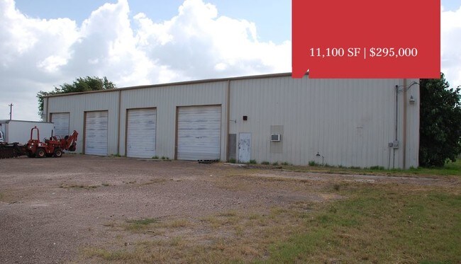
11,780 SF
Brownsville-Harlingen, TX
NEARBY LISTINGS FOR SALE OR LEASE
DEMOGRAPHICS near 77 # 77
1 mile
3 mile
5 mile
2025 Total Population
2,761
26,955
71,476
2030 Population
2,800
27,565
73,179
Pop Growth 2025-2030
+ 1.41%
+ 2.26%
+ 2.38%
Average Age
39
37
38
2025 Total Households
879
8,775
24,492
HH Growth 2025-2030
+ 1.25%
+ 2.36%
+ 2.60%
Median Household Inc
$44,558
$60,061
$55,224
Avg Household Size
3.10
3.00
2.80
2025 Avg HH Vehicles
2.00
2.00
2.00
Median Home Value
$149,640
$154,646
$149,908
Median Year Built
1987
1992
1987
Nearby Places
Map Layers
Map Styles
 Street
 Aerial
Layers
 Traffic
 Biking
Places
Listings with unknown addresses are not visible on the map
- Restaurants
- Banks
- Shops
- Fitness
- Groceries
PUBLIC TRANSPORTATION
AIRPORT
Valley International
Drive
Walk
Distance
Valley International
9 min
5.1 mi
Brownsville/South Padre Island International
Drive
Walk
Distance
Brownsville/South Padre Island International
41 min
32.1 mi
Freight Ports
Port of Brownsville
Drive
Walk
Distance
Port of Brownsville
34 min
29.8 mi
SALE & LEASE HISTORY
LISTING DATE
SALE/LEASE

Jun 06, 2019
For Sale
Aug 18, 2020
For Lease
Nearby Properties
Address
Land Use
TOTAL SIZE
Lot Size
Zoning
Address
Land Use
TOTAL SIZE
Lot Size
Zoning
43,540 SF
26.19 AC
C
Address
Land Use
TOTAL SIZE
Lot Size
Zoning
74,848 SF
2.30 AC
Address
Land Use
TOTAL SIZE
Lot Size
Zoning
13,924 SF
31.33 AC
C
Address
Land Use
TOTAL SIZE
Lot Size
Zoning
76,756 SF
15.35 AC
Address
Land Use
TOTAL SIZE
Lot Size
Zoning
81,569 SF
36.61 AC
Address
Land Use
TOTAL SIZE
Lot Size
Zoning
20.64 AC
C
Address
Land Use
TOTAL SIZE
Lot Size
Zoning
144,000 SF
7.05 AC
Address
Land Use
TOTAL SIZE
Lot Size
Zoning
43,715 SF
8 AC
Address
Land Use
TOTAL SIZE
Lot Size
Zoning
194,090 SF
13.17 AC
C
Address
Land Use
TOTAL SIZE
Lot Size
Zoning
1,216 SF
39.91 AC
A-R
Address
Land Use
TOTAL SIZE
Lot Size
Zoning
141,841 SF
9.99 AC
Address
Land Use
TOTAL SIZE
Lot Size
Zoning
13,496 SF
0.99 AC
Address
Land Use
TOTAL SIZE
Lot Size
Zoning
256,460 SF
19.15 AC
C
Address
Land Use
TOTAL SIZE
Lot Size
Zoning
41,600 SF
10 AC
C
Address
Land Use
TOTAL SIZE
Lot Size
Zoning
52,630 SF
15 AC
Address
Land Use
TOTAL SIZE
Lot Size
Zoning
7,947 SF
16.10 AC
CRV
Address
Land Use
TOTAL SIZE
Lot Size
Zoning
5.22 AC
M-U
Address
Land Use
TOTAL SIZE
Lot Size
Zoning
48,841 SF
6.99 AC
C
Address
Land Use
TOTAL SIZE
Lot Size
Zoning
87,573 SF
8.45 AC
C
Address
Land Use
TOTAL SIZE
Lot Size
Zoning
125,000 SF
6.63 AC
C
Address
Land Use
TOTAL SIZE
Lot Size
Zoning
32,225 SF
3.33 AC
Address
Land Use
TOTAL SIZE
Lot Size
Zoning
63,714 SF
17.51 AC
Address
Land Use
TOTAL SIZE
Lot Size
Zoning
83,056 SF
6.39 AC
C
Address
Land Use
TOTAL SIZE
Lot Size
Zoning
22,476 SF
0.85 AC
Address
Land Use
TOTAL SIZE
Lot Size
Zoning
131,476 SF
6.63 AC
C
Address
Land Use
TOTAL SIZE
Lot Size
Zoning
115,352 SF
12.60 AC
C
Address
Land Use
TOTAL SIZE
Lot Size
Zoning
25,911 SF
8.94 AC
AC
Address
Land Use
TOTAL SIZE
Lot Size
Zoning
32,550 SF
5.22 AC
Address
Land Use
TOTAL SIZE
Lot Size
Zoning
47,310 SF
5.68 AC
C
Address
Land Use
TOTAL SIZE
Lot Size
Zoning
18,168 SF
2.08 AC
The World's #1 Commercial Real Estate Marketplace
Connect with us
© 2026 CoStar Group
The information above has been obtained from sources believed reliable. While we do not doubt its accuracy we have not verified it and make no guarantee, warranty or representation about it. It is your responsibility to independently confirm its accuracy and completeness. Any projections, opinions, assumptions, or estimates used are for example only and do not represent the current or future performance of the property. The value of this transaction to you depends on tax and other factors which should be evaluated by your tax, financial, and legal advisors. You and your advisors should conduct a careful, independent investigation of the property to determine to your satisfaction the suitability of the property for your needs.