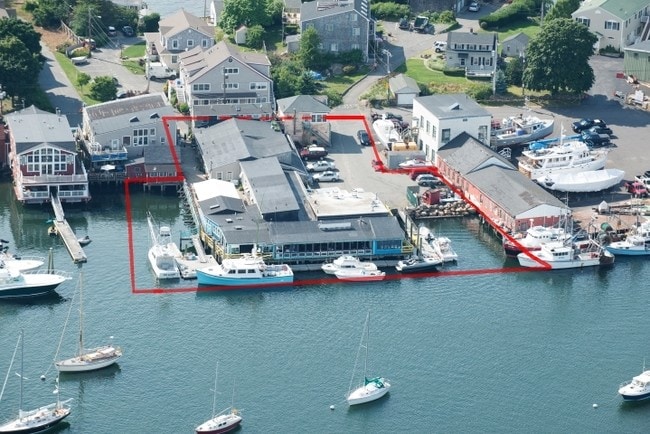
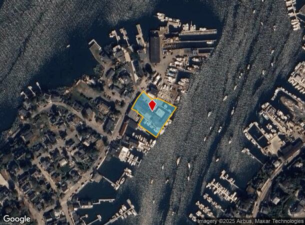
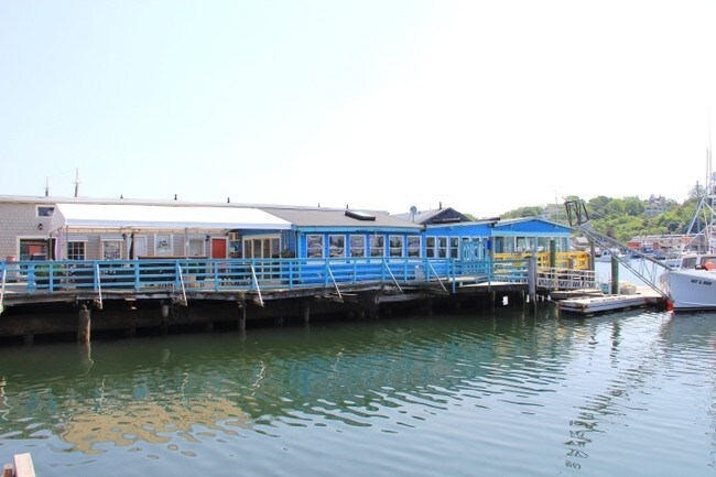
Property Record
77 Rocky Neck Ave, Gloucester, MA 01930
NEARBY LISTINGS FOR SALE OR LEASE
Property Detail
77 Rocky Neck Ave
GLOU-000128-000041
Essex
Commercialofficeresidentialmixeduse
Massachusetts
AE
0.81 AC
25009C0457G
Essex/Gloucester
2025
Boston
2025
Boston-Cambridge-Newton, MA-NH
221300
DEMOGRAPHICS near 77 Rocky Neck Ave
1 Mile
3 Mile
5 Mile
2024 Total Population
11,165
24,454
39,327
2029 Population
11,114
24,485
39,703
Pop Growth 2024-2029
(0.46%)
+ 0.13%
+ 0.96%
Average Age
45
46
47
2024 Total Households
5,323
10,956
17,684
HH Growth 2024-2029
(0.60%)
(0.03%)
+ 0.83%
Median Household Inc
$71,577
$82,667
$88,588
Avg Household Size
2.10
2.20
2.20
2024 Avg HH Vehicles
1.00
2.00
2.00
Median Home Value
$493,096
$585,147
$636,097
Median Year Built
1947
1948
1950
Nearby Places
Map Layers
Map Styles
 Street
 Aerial
- Restaurants
- Banks
- Shops
- Fitness
- Groceries
PUBLIC TRANSPORTATION
COMMUTER RAIL
Gloucester (Newburyport/Rockport Line - Massachusetts Bay Transportation Authority Commuter Rail (Purple Line))
DRIVE
WALK
Distance
Gloucester (Newburyport/Rockport Line - Massachusetts Bay Transportation Authority Commuter Rail (Purple Line))
15 min
3.0 mi
Rockport (Newburyport/Rockport Line - Massachusetts Bay Transportation Authority Commuter Rail (Purple Line))
DRIVE
WALK
Distance
Rockport (Newburyport/Rockport Line - Massachusetts Bay Transportation Authority Commuter Rail (Purple Line))
17 min
5.0 mi
AIRPORT
General Edward Lawrence Logan International
DRIVE
WALK
Distance
General Edward Lawrence Logan International
60 min
37.0 mi
Freight Ports
Port of Boston
DRIVE
WALK
Distance
Port of Boston
1 min
26.2 mi
SALE & LEASE HISTORY
LISTING DATE
SALE/LEASE

Sep 23, 2016
For Sale
Nearby Properties
Address
Land Use
TOTAL SIZE
Lot Size
Zoning
Address
Land Use
TOTAL SIZE
Lot Size
Zoning
187,125 SF
6.22 AC
R-10
Address
Land Use
TOTAL SIZE
Lot Size
Zoning
246,863 SF
18.84 AC
R-20
Address
Land Use
TOTAL SIZE
Lot Size
Zoning
17.56 AC
R-10
Address
Land Use
TOTAL SIZE
Lot Size
Zoning
86,922 SF
7.25 AC
R-20
Address
Land Use
TOTAL SIZE
Lot Size
Zoning
31.17 AC
EB
Address
Land Use
TOTAL SIZE
Lot Size
Zoning
11,513 SF
17.50 AC
R-20
Address
Land Use
TOTAL SIZE
Lot Size
Zoning
60,000 SF
9.91 AC
R-10
Address
Land Use
TOTAL SIZE
Lot Size
Zoning
1,834 SF
23.45 AC
R-10
Address
Land Use
TOTAL SIZE
Lot Size
Zoning
67,972 SF
20.94 AC
R-20
Address
Land Use
TOTAL SIZE
Lot Size
Zoning
19.43 AC
BP
Address
Land Use
TOTAL SIZE
Lot Size
Zoning
85,464 SF
1.85 AC
MI
Address
Land Use
TOTAL SIZE
Lot Size
Zoning
20,109 SF
30.81 AC
RC-40
Address
Land Use
TOTAL SIZE
Lot Size
Zoning
19.26 AC
BP
Address
Land Use
TOTAL SIZE
Lot Size
Zoning
99,838 SF
7.48 AC
BP
Address
Land Use
TOTAL SIZE
Lot Size
Zoning
1,872 SF
54.90 AC
R-10
Address
Land Use
TOTAL SIZE
Lot Size
Zoning
59,161 SF
5.12 AC
EB
Address
Land Use
TOTAL SIZE
Lot Size
Zoning
8.42 AC
EB
Address
Land Use
TOTAL SIZE
Lot Size
Zoning
14,493 SF
3.98 AC
R-5
Address
Land Use
TOTAL SIZE
Lot Size
Zoning
66,657 SF
0.77 AC
R-5
Address
Land Use
TOTAL SIZE
Lot Size
Zoning
47,350 SF
3.52 AC
BP
Address
Land Use
TOTAL SIZE
Lot Size
Zoning
2.60 AC
MI
Address
Land Use
TOTAL SIZE
Lot Size
Zoning
158,752 SF
10.38 AC
BP
Address
Land Use
TOTAL SIZE
Lot Size
Zoning
1.49 AC
R-5
Address
Land Use
TOTAL SIZE
Lot Size
Zoning
14,042 SF
12 AC
R-20
Address
Land Use
TOTAL SIZE
Lot Size
Zoning
14,914 SF
2.25 AC
RC-40
Address
Land Use
TOTAL SIZE
Lot Size
Zoning
71,950 SF
1 AC
CCD
Address
Land Use
TOTAL SIZE
Lot Size
Zoning
65,108 SF
7.37 AC
EB
Address
Land Use
TOTAL SIZE
Lot Size
Zoning
138,050 SF
2.63 AC
MI
Address
Land Use
TOTAL SIZE
Lot Size
Zoning
56,266 SF
9.59 AC
BP
Address
Land Use
TOTAL SIZE
Lot Size
Zoning
12,028 SF
0.75 AC
RC-40
The World's #1 Commercial Real Estate Marketplace
Connect with us
© 2026 CoStar Group
The information above has been obtained from sources believed reliable. While we do not doubt its accuracy we have not verified it and make no guarantee, warranty or representation about it. It is your responsibility to independently confirm its accuracy and completeness. Any projections, opinions, assumptions, or estimates used are for example only and do not represent the current or future performance of the property. The value of this transaction to you depends on tax and other factors which should be evaluated by your tax, financial, and legal advisors. You and your advisors should conduct a careful, independent investigation of the property to determine to your satisfaction the suitability of the property for your needs.