Property Record
County Road 85 Laigle Rd, Manvel, TX 77578


NEARBY LISTINGS FOR SALE OR LEASE
Property Detail
County Road 85 Laigle Rd
Houston-The Woodlands-Sugar Land, TX
A C H & B
0417-0032-000
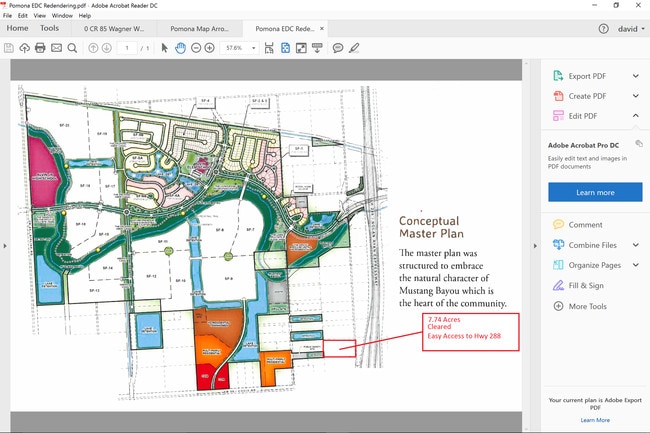
A0417 A C H & B TRACT 38A-39 ACRES 7.74
Agriculturalland
Brazoria
AE
Texas
48039C0020K
7.74 AC
2024
South
2025
Houston
660702
DEMOGRAPHICS near County Road 85 Laigle Rd
1 Mile
3 Mile
5 Mile
2024 Total Population
3,746
56,623
138,736
2029 Population
4,280
63,424
157,056
Pop Growth 2024-2029
+ 14.26%
+ 12.01%
+ 13.20%
Average Age
34
35
36
2024 Total Households
1,209
18,132
45,550
HH Growth 2024-2029
+ 14.39%
+ 12.04%
+ 13.23%
Median Household Inc
$100,287
$123,705
$105,813
Avg Household Size
3.10
3.10
3.00
2024 Avg HH Vehicles
2.00
2.00
2.00
Median Home Value
$330,411
$339,838
$314,316
Median Year Built
2011
2008
2007
Nearby Places
Map Layers
Map Styles
 Street
 Aerial
- Restaurants
- Banks
- Shops
- Fitness
- Groceries
PUBLIC TRANSPORTATION
AIRPORT
William P Hobby
DRIVE
WALK
Distance
William P Hobby
29 min
15.8 mi
George Bush Intcntl/Houston
DRIVE
WALK
Distance
George Bush Intcntl/Houston
48 min
36.3 mi
Freight Ports
Port of Houston
DRIVE
WALK
Distance
Port of Houston
34 min
22.5 mi
SALE & LEASE HISTORY
LISTING DATE
SALE/LEASE

Sep 28, 2016
For Sale
Sep 24, 2016
For Sale
Nearby Properties
Address
Land Use
TOTAL SIZE
Lot Size
Zoning
Address
Land Use
TOTAL SIZE
Lot Size
Zoning
241,351 SF
60.11 AC
Address
Land Use
TOTAL SIZE
Lot Size
Zoning
367,766 SF
43.71 AC
Address
Land Use
TOTAL SIZE
Lot Size
Zoning
369,539 SF
30.71 AC
Address
Land Use
TOTAL SIZE
Lot Size
Zoning
372,280 SF
14.70 AC
0021
Address
Land Use
TOTAL SIZE
Lot Size
Zoning
319,173 SF
7.67 AC
Address
Land Use
TOTAL SIZE
Lot Size
Zoning
321,409 SF
13.90 AC
Address
Land Use
TOTAL SIZE
Lot Size
Zoning
323,168 SF
12.80 AC
Address
Land Use
TOTAL SIZE
Lot Size
Zoning
379,493 SF
14.27 AC
Address
Land Use
TOTAL SIZE
Lot Size
Zoning
225,854 SF
10.44 AC
Address
Land Use
TOTAL SIZE
Lot Size
Zoning
240,616 SF
10.01 AC
Address
Land Use
TOTAL SIZE
Lot Size
Zoning
66,998 SF
11.34 AC
Address
Land Use
TOTAL SIZE
Lot Size
Zoning
115,423 SF
12.13 AC
Address
Land Use
TOTAL SIZE
Lot Size
Zoning
241,488 SF
9.81 AC
Address
Land Use
TOTAL SIZE
Lot Size
Zoning
215,063 SF
19.13 AC
Address
Land Use
TOTAL SIZE
Lot Size
Zoning
228,276 SF
9.43 AC
0036
Address
Land Use
TOTAL SIZE
Lot Size
Zoning
106,627 SF
8.40 AC
Address
Land Use
TOTAL SIZE
Lot Size
Zoning
172,256 SF
6.13 AC
Address
Land Use
TOTAL SIZE
Lot Size
Zoning
66,060 SF
12.85 AC
0016
Address
Land Use
TOTAL SIZE
Lot Size
Zoning
81,170 SF
50 AC
Address
Land Use
TOTAL SIZE
Lot Size
Zoning
84,604 SF
8.29 AC
0039
Address
Land Use
TOTAL SIZE
Lot Size
Zoning
70,033 SF
17.97 AC
Address
Land Use
TOTAL SIZE
Lot Size
Zoning
107,915 SF
9.29 AC
Address
Land Use
TOTAL SIZE
Lot Size
Zoning
58,985 SF
4.34 AC
Address
Land Use
TOTAL SIZE
Lot Size
Zoning
152,722 SF
16.70 AC
Address
Land Use
TOTAL SIZE
Lot Size
Zoning
59,618 SF
4.50 AC
Address
Land Use
TOTAL SIZE
Lot Size
Zoning
49,404 SF
1.90 AC
Address
Land Use
TOTAL SIZE
Lot Size
Zoning
210,939 SF
18.74 AC
0001
Address
Land Use
TOTAL SIZE
Lot Size
Zoning
15.28 AC
0015
Address
Land Use
TOTAL SIZE
Lot Size
Zoning
97,518 SF
4.76 AC
Address
Land Use
TOTAL SIZE
Lot Size
Zoning
13.85 AC
The World's #1 Commercial Real Estate Marketplace
Connect with us
© 2026 CoStar Group
The information above has been obtained from sources believed reliable. While we do not doubt its accuracy we have not verified it and make no guarantee, warranty or representation about it. It is your responsibility to independently confirm its accuracy and completeness. Any projections, opinions, assumptions, or estimates used are for example only and do not represent the current or future performance of the property. The value of this transaction to you depends on tax and other factors which should be evaluated by your tax, financial, and legal advisors. You and your advisors should conduct a careful, independent investigation of the property to determine to your satisfaction the suitability of the property for your needs.