Property Record
77 Bethany Rd, Framingham, MA 01702
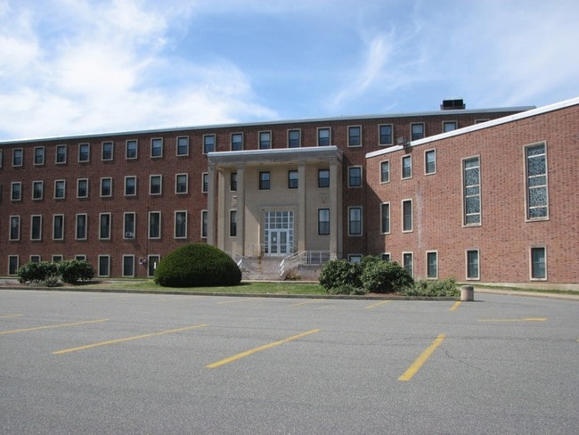

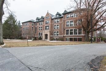
Property Detail
77 Bethany Rd
FRAM-000139-000042-002777
MIDDLESEX
Religious
Massachusetts
R3
1067
B and X Area of moderate flood hazard, usually the area between the limits of the 100-year and 500-year floods.
39.70 AC
0
Framingham/Natick
2025
Boston
383300
Boston-Cambridge-Newton, MA-NH
154,724 SF
NEARBY LISTINGS FOR SALE OR LEASE
-
-
View all Framingham listings for lease on LoopNet.com
DEMOGRAPHICS near 77 Bethany Rd
1 mile
3 mile
5 mile
2025 Total Population
10,941
79,805
148,570
2030 Population
11,290
83,368
154,819
Pop Growth 2025-2030
+ 3.19%
+ 4.46%
+ 4.21%
Average Age
38
40
41
2025 Total Households
3,756
30,573
56,996
HH Growth 2025-2030
+ 3.46%
+ 4.60%
+ 4.32%
Median Household Inc
$98,562
$101,142
$117,406
Avg Household Size
2.70
2.40
2.50
2025 Avg HH Vehicles
2.00
2.00
2.00
Median Home Value
$621,517
$671,082
$722,065
Median Year Built
1958
1971
1969
Nearby Places
Map Layers
Map Styles
 Street
 Aerial
Layers
 Traffic
 Biking
Places
Listings with unknown addresses are not visible on the map
- Restaurants
- Banks
- Shops
- Fitness
- Groceries
PUBLIC TRANSPORTATION
COMMUTER RAIL
Framingham Amtrak (Lake Shore Limited - Amtrak)
Drive
Walk
Distance
Framingham Amtrak (Lake Shore Limited - Amtrak)
4 min
1.1 mi
Framingham (Framingham/Worcester Line - Massachusetts Bay Transportation Authority Commuter Rail (Purple Line))
Drive
Walk
Distance
Framingham (Framingham/Worcester Line - Massachusetts Bay Transportation Authority Commuter Rail (Purple Line))
4 min
1.2 mi
AIRPORT
General Edward Lawrence Logan International
Drive
Walk
Distance
General Edward Lawrence Logan International
43 min
26.1 mi
Worcester Regional
Drive
Walk
Distance
Worcester Regional
49 min
26.9 mi
Freight Ports
Port of Boston
Drive
Walk
Distance
Port of Boston
41 min
24.4 mi
SALE & LEASE HISTORY
LISTING DATE
SALE/LEASE

Sep 25, 2016
For Lease
Sep 24, 2016
For Sale
Mar 29, 2017
For Sale
Aug 01, 2017
For Lease
Nearby Properties
Address
Land Use
TOTAL SIZE
Lot Size
Zoning
Address
Land Use
TOTAL SIZE
Lot Size
Zoning
478,440 SF
11.97 AC
B
Address
Land Use
TOTAL SIZE
Lot Size
Zoning
556,849 SF
28.44 AC
R4
Address
Land Use
TOTAL SIZE
Lot Size
Zoning
340,840 SF
4.25 AC
B
Address
Land Use
TOTAL SIZE
Lot Size
Zoning
137,000 SF
18.96 AC
R1
Address
Land Use
TOTAL SIZE
Lot Size
Zoning
292,608 SF
5.19 AC
B
Address
Land Use
TOTAL SIZE
Lot Size
Zoning
493,918 SF
28.90 AC
R1
Address
Land Use
TOTAL SIZE
Lot Size
Zoning
293,180 SF
5.10 AC
B
Address
Land Use
TOTAL SIZE
Lot Size
Zoning
315,055 SF
40.38 AC
G
Address
Land Use
TOTAL SIZE
Lot Size
Zoning
20,704 SF
13.36 AC
PCD
Address
Land Use
TOTAL SIZE
Lot Size
Zoning
264,247 SF
6.09 AC
M1
Address
Land Use
TOTAL SIZE
Lot Size
Zoning
273,474 SF
7.46 AC
B
Address
Land Use
TOTAL SIZE
Lot Size
Zoning
256,830 SF
12.61 AC
B
Address
Land Use
TOTAL SIZE
Lot Size
Zoning
207,522 SF
10.11 AC
B
Address
Land Use
TOTAL SIZE
Lot Size
Zoning
191,520 SF
7.99 AC
B
Address
Land Use
TOTAL SIZE
Lot Size
Zoning
191,520 SF
5.03 AC
B
Address
Land Use
TOTAL SIZE
Lot Size
Zoning
244,033 SF
25.75 AC
R1
Address
Land Use
TOTAL SIZE
Lot Size
Zoning
199,320 SF
16.65 AC
RSA
Address
Land Use
TOTAL SIZE
Lot Size
Zoning
108.84 AC
M
Address
Land Use
TOTAL SIZE
Lot Size
Zoning
372,275 SF
3.05 AC
CB
Address
Land Use
TOTAL SIZE
Lot Size
Zoning
139,356 SF
52 AC
30
Address
Land Use
TOTAL SIZE
Lot Size
Zoning
251,366 SF
14.42 AC
G
Address
Land Use
TOTAL SIZE
Lot Size
Zoning
231,897 SF
7.90 AC
B
Address
Land Use
TOTAL SIZE
Lot Size
Zoning
3.02 AC
CB
Address
Land Use
TOTAL SIZE
Lot Size
Zoning
112,000 SF
18.48 AC
R1
Address
Land Use
TOTAL SIZE
Lot Size
Zoning
112,000 SF
15.11 AC
G
Address
Land Use
TOTAL SIZE
Lot Size
Zoning
150,636 SF
30.34 AC
GE
Address
Land Use
TOTAL SIZE
Lot Size
Zoning
140,695 SF
2.52 AC
G
Address
Land Use
TOTAL SIZE
Lot Size
Zoning
135,535 SF
16.01 AC
B
Address
Land Use
TOTAL SIZE
Lot Size
Zoning
91,461 SF
22.63 AC
R1
The World's #1 Commercial Real Estate Marketplace
Connect with us
© 2026 CoStar Group
The information above has been obtained from sources believed reliable. While we do not doubt its accuracy we have not verified it and make no guarantee, warranty or representation about it. It is your responsibility to independently confirm its accuracy and completeness. Any projections, opinions, assumptions, or estimates used are for example only and do not represent the current or future performance of the property. The value of this transaction to you depends on tax and other factors which should be evaluated by your tax, financial, and legal advisors. You and your advisors should conduct a careful, independent investigation of the property to determine to your satisfaction the suitability of the property for your needs.