No Photo
Property Record
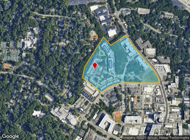
77 E Andrews Dr Nw, Atlanta, GA 30305
NEARBY LISTINGS FOR SALE OR LEASE
Property Detail
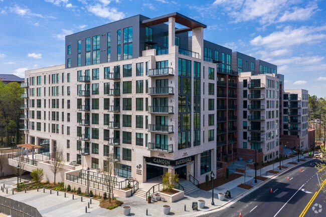
77 E Andrews Dr Nw
Atlanta-Sandy Springs-Roswell, GA
Buckhead
17-0099-LL-042-9
KA CAMDEN PACES/CAMDEN BUCKHEAD PARCEL REVIEW ** UPDATE FLD CK REQ RMV TY22 HOF OVRR VALUE
Apartment
Fulton
X
Georgia
13121C0232F
1-3
2024
25.12 AC
2025
Tuxedo Park
009504
Atlanta
1,572,131 SF
DEMOGRAPHICS near 77 E Andrews Dr Nw
1 Mile
3 Mile
5 Mile
2024 Total Population
25,331
127,229
326,017
2029 Population
26,856
131,387
333,275
Pop Growth 2024-2029
+ 6.02%
+ 3.27%
+ 2.23%
Average Age
40
39
37
2024 Total Households
15,515
66,053
159,504
HH Growth 2024-2029
+ 6.16%
+ 3.60%
+ 2.56%
Median Household Inc
$99,672
$107,852
$105,879
Avg Household Size
1.60
1.90
1.90
2024 Avg HH Vehicles
1.00
1.00
1.00
Median Home Value
$613,537
$734,320
$667,142
Median Year Built
2004
1995
1993
Nearby Places
Map Layers
Map Styles
 Street
 Aerial
- Restaurants
- Banks
- Shops
- Fitness
- Groceries
PUBLIC TRANSPORTATION
COMMUTER RAIL
Atlanta (Crescent - Amtrak)
DRIVE
WALK
Distance
Atlanta (Crescent - Amtrak)
5 min
3.6 mi
AIRPORT
Hartsfield - Jackson Atlanta International
DRIVE
WALK
Distance
Hartsfield - Jackson Atlanta International
26 min
16.7 mi
Freight Ports
Georgia Ports - Savannah
DRIVE
WALK
Distance
Georgia Ports - Savannah
289 min
256.0 mi
Nearby Properties
Address
Land Use
TOTAL SIZE
Lot Size
Zoning
Address
Land Use
TOTAL SIZE
Lot Size
Zoning
11,126,925 SF
43.33 AC
C3
Address
Land Use
TOTAL SIZE
Lot Size
Zoning
3,356,268 SF
14.72 AC
C3
Address
Land Use
TOTAL SIZE
Lot Size
Zoning
2,044,200 SF
9.16 AC
C3
Address
Land Use
TOTAL SIZE
Lot Size
Zoning
903,671 SF
1 AC
C3
Address
Land Use
TOTAL SIZE
Lot Size
Zoning
654,394 SF
2.27 AC
C1C
Address
Land Use
TOTAL SIZE
Lot Size
Zoning
844,000 SF
2.33 AC
PDMU
Address
Land Use
TOTAL SIZE
Lot Size
Zoning
702,901 SF
3.72 AC
PDOC
Address
Land Use
TOTAL SIZE
Lot Size
Zoning
1,242,520 SF
3.38 AC
PDMU
Address
Land Use
TOTAL SIZE
Lot Size
Zoning
1,233,815 SF
2.18 AC
PDMU
Address
Land Use
TOTAL SIZE
Lot Size
Zoning
687,016 SF
4.21 AC
R4
Address
Land Use
TOTAL SIZE
Lot Size
Zoning
1,021,058 SF
2.89 AC
C3
Address
Land Use
TOTAL SIZE
Lot Size
Zoning
598,962 SF
4.50 AC
PDOC
Address
Land Use
TOTAL SIZE
Lot Size
Zoning
835,636 SF
5.63 AC
PDOC
Address
Land Use
TOTAL SIZE
Lot Size
Zoning
899,673 SF
2.15 AC
PDMU
Address
Land Use
TOTAL SIZE
Lot Size
Zoning
188,648 SF
4.39 AC
X
Address
Land Use
TOTAL SIZE
Lot Size
Zoning
1,006,124 SF
2.97 AC
RG4C
Address
Land Use
TOTAL SIZE
Lot Size
Zoning
32.79 AC
R3
Address
Land Use
TOTAL SIZE
Lot Size
Zoning
12.97 AC
C3
Address
Land Use
TOTAL SIZE
Lot Size
Zoning
2,820,296 SF
9.58 AC
RG5
Address
Land Use
TOTAL SIZE
Lot Size
Zoning
458,822 SF
2.86 AC
RG2
Address
Land Use
TOTAL SIZE
Lot Size
Zoning
863,826 SF
3.79 AC
C4
Address
Land Use
TOTAL SIZE
Lot Size
Zoning
1,092,973 SF
4.11 AC
C1C
Address
Land Use
TOTAL SIZE
Lot Size
Zoning
664,442 SF
4.76 AC
RG3
Address
Land Use
TOTAL SIZE
Lot Size
Zoning
754,619 SF
27.30 AC
RG3C
Address
Land Use
TOTAL SIZE
Lot Size
Zoning
527,188 SF
2.06 AC
PDOC
Address
Land Use
TOTAL SIZE
Lot Size
Zoning
619,288 SF
3.51 AC
OI
Address
Land Use
TOTAL SIZE
Lot Size
Zoning
645,419 SF
1.11 AC
C3
Address
Land Use
TOTAL SIZE
Lot Size
Zoning
389,560 SF
4.01 AC
C1
Address
Land Use
TOTAL SIZE
Lot Size
Zoning
703,243 SF
1.17 AC
PDOC
The World's #1 Commercial Real Estate Marketplace
Connect with us
© 2026 CoStar Group
The information above has been obtained from sources believed reliable. While we do not doubt its accuracy we have not verified it and make no guarantee, warranty or representation about it. It is your responsibility to independently confirm its accuracy and completeness. Any projections, opinions, assumptions, or estimates used are for example only and do not represent the current or future performance of the property. The value of this transaction to you depends on tax and other factors which should be evaluated by your tax, financial, and legal advisors. You and your advisors should conduct a careful, independent investigation of the property to determine to your satisfaction the suitability of the property for your needs.