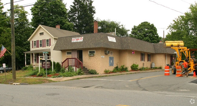
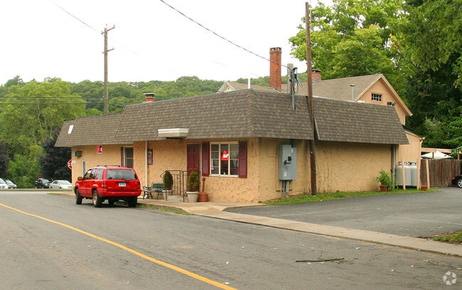
Property Record
77 Main St, Deep River, CT 06417

Property Detail
77 Main St
DEEP-000056-000000-000082
Lower Ct River Vly
Restaurantbuilding
Connecticut
VMU
82
B and X Area of moderate flood hazard, usually the area between the limits of the 100-year and 500-year floods.
0.29 AC
2024
SW Midlsx/Old Saybrk/Rt 9
2025
Hartford
620100
Hartford-West Hartford-East Hartford, CT
4,754 SF
NEARBY LISTINGS FOR SALE OR LEASE
DEMOGRAPHICS near 77 Main St
1 mile
3 mile
5 mile
2025 Total Population
2,623
8,162
19,096
2030 Population
2,650
8,216
19,289
Pop Growth 2025-2030
+ 1.03%
+ 0.66%
+ 1.01%
Average Age
46
48
49
2025 Total Households
1,214
3,655
8,334
HH Growth 2025-2030
+ 1.07%
+ 0.63%
+ 1.01%
Median Household Inc
$70,680
$87,226
$100,551
Avg Household Size
2.10
2.20
2.20
2025 Avg HH Vehicles
2.00
2.00
2.00
Median Home Value
$354,849
$421,092
$457,631
Median Year Built
1958
1961
1968
Nearby Places
Map Layers
Map Styles
 Street
 Aerial
Transit
 Traffic
 Biking
Places
Listings with unknown addresses are not visible on the map
- Restaurants
- Banks
- Shops
- Fitness
- Groceries
PUBLIC TRANSPORTATION
COMMUTER RAIL
Westbrook (Commuter Rail - Shore Line East)
Drive
Walk
Distance
Westbrook (Commuter Rail - Shore Line East)
15 min
8.1 mi
Old Saybrook (Shore Line East - Shore Line East)
Drive
Walk
Distance
Old Saybrook (Shore Line East - Shore Line East)
14 min
8.3 mi
AIRPORT
Tweed/New Haven
Drive
Walk
Distance
Tweed/New Haven
45 min
31.9 mi
Freight Ports
Port of New Haven
Drive
Walk
Distance
Port of New Haven
45 min
32.5 mi
SALE & LEASE HISTORY
LISTING DATE
SALE/LEASE

Jun 20, 2018
For Lease
Jun 20, 2018
For Sale
Nearby Properties
Address
Land Use
TOTAL SIZE
Lot Size
Zoning
Address
Land Use
TOTAL SIZE
Lot Size
Zoning
66.05 AC
PRD
Address
Land Use
TOTAL SIZE
Lot Size
Zoning
38.67 AC
R60
Address
Land Use
TOTAL SIZE
Lot Size
Zoning
50,026 SF
12.87 AC
R-1
Address
Land Use
TOTAL SIZE
Lot Size
Zoning
7.60 AC
VRD
Address
Land Use
TOTAL SIZE
Lot Size
Zoning
14.98 AC
VR
Address
Land Use
TOTAL SIZE
Lot Size
Zoning
43,023 SF
1.08 AC
GCD
Address
Land Use
TOTAL SIZE
Lot Size
Zoning
23.16 AC
Address
Land Use
TOTAL SIZE
Lot Size
Zoning
16,008 SF
1.50 AC
C
Address
Land Use
TOTAL SIZE
Lot Size
Zoning
84.30 AC
R60
Address
Land Use
TOTAL SIZE
Lot Size
Zoning
18.49 AC
HDD
Address
Land Use
TOTAL SIZE
Lot Size
Zoning
18.90 AC
WD2
Address
Land Use
TOTAL SIZE
Lot Size
Zoning
151,159 SF
6.30 AC
VID
Address
Land Use
TOTAL SIZE
Lot Size
Zoning
30.70 AC
Address
Land Use
TOTAL SIZE
Lot Size
Zoning
13,739 SF
0.65 AC
VCD
Address
Land Use
TOTAL SIZE
Lot Size
Zoning
14,016 SF
16.03 AC
R-1
Address
Land Use
TOTAL SIZE
Lot Size
Zoning
146,466 SF
13.55 AC
VID
Address
Land Use
TOTAL SIZE
Lot Size
Zoning
22.26 AC
R-1
Address
Land Use
TOTAL SIZE
Lot Size
Zoning
27,225 SF
2.45 AC
VCD
Address
Land Use
TOTAL SIZE
Lot Size
Zoning
63,938 SF
9.79 AC
CDD
Address
Land Use
TOTAL SIZE
Lot Size
Zoning
6.51 AC
R80
Address
Land Use
TOTAL SIZE
Lot Size
Zoning
19.27 AC
R-2
Address
Land Use
TOTAL SIZE
Lot Size
Zoning
14,382 SF
1.87 AC
VMU
Address
Land Use
TOTAL SIZE
Lot Size
Zoning
16.67 AC
Address
Land Use
TOTAL SIZE
Lot Size
Zoning
50.35 AC
CIP
Address
Land Use
TOTAL SIZE
Lot Size
Zoning
15.70 AC
WD2
Address
Land Use
TOTAL SIZE
Lot Size
Zoning
6,978 SF
164.08 AC
R-2
Address
Land Use
TOTAL SIZE
Lot Size
Zoning
10,583 SF
0.29 AC
VCD
Address
Land Use
TOTAL SIZE
Lot Size
Zoning
9.31 AC
R80
Address
Land Use
TOTAL SIZE
Lot Size
Zoning
2.76 AC
R30
Address
Land Use
TOTAL SIZE
Lot Size
Zoning
3.72 AC
R80
The World's #1 Commercial Real Estate Marketplace
Connect with us
© 2026 CoStar Group
The information above has been obtained from sources believed reliable. While we do not doubt its accuracy we have not verified it and make no guarantee, warranty or representation about it. It is your responsibility to independently confirm its accuracy and completeness. Any projections, opinions, assumptions, or estimates used are for example only and do not represent the current or future performance of the property. The value of this transaction to you depends on tax and other factors which should be evaluated by your tax, financial, and legal advisors. You and your advisors should conduct a careful, independent investigation of the property to determine to your satisfaction the suitability of the property for your needs.