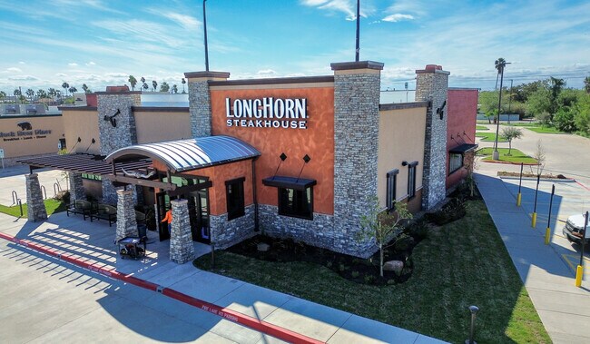
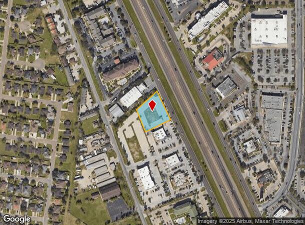
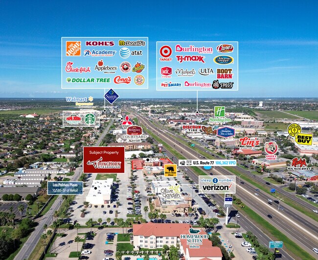
Property Record
77 N Expressway, Brownsville, TX 78526
NEARBY LISTINGS FOR SALE OR LEASE
Property Detail
77 N Expressway
Brownsville/Harlingen
Las Palmas-Sierra Gorda Subdivision
Brownsville-Harlingen, TX
LOT 4B LAS PALMAS-SIERRA GORDA SUBDIVISION (2023 REPLAT C1-4315 & 4317 CCMR FILED 01/03 & 01/11/2022)
020301-0000-004011
Cameron
Commercialnec
Texas
2024
4b
2025
0.85 AC
013002
Greater Brownsville
5,796 SF
DEMOGRAPHICS near 77 N Expressway
1 Mile
3 Mile
5 Mile
2024 Total Population
9,905
94,343
160,643
2029 Population
10,088
96,166
164,454
Pop Growth 2024-2029
+ 1.85%
+ 1.93%
+ 2.37%
Average Age
38
36
35
2024 Total Households
3,461
29,820
50,220
HH Growth 2024-2029
+ 1.82%
+ 1.97%
+ 2.37%
Median Household Inc
$53,066
$57,409
$51,100
Avg Household Size
2.80
3.10
3.10
2024 Avg HH Vehicles
2.00
2.00
2.00
Median Home Value
$118,824
$131,903
$119,234
Median Year Built
1993
1995
1992
Nearby Places
Map Layers
Map Styles
 Street
 Aerial
- Restaurants
- Banks
- Shops
- Fitness
- Groceries
PUBLIC TRANSPORTATION
AIRPORT
Brownsville/South Padre Island International
DRIVE
WALK
Distance
Brownsville/South Padre Island International
13 min
7.0 mi
Valley International
DRIVE
WALK
Distance
Valley International
33 min
23.7 mi
Freight Ports
Port of Brownsville
DRIVE
WALK
Distance
Port of Brownsville
13 min
6.9 mi
SALE & LEASE HISTORY
LISTING DATE
SALE/LEASE

Jan 09, 2024
For Sale
Nearby Properties
Address
Land Use
TOTAL SIZE
Lot Size
Zoning
Address
Land Use
TOTAL SIZE
Lot Size
Zoning
319,798 SF
46.28 AC
Address
Land Use
TOTAL SIZE
Lot Size
Zoning
452,559 SF
13.79 AC
C
Address
Land Use
TOTAL SIZE
Lot Size
Zoning
232,467 SF
25.82 AC
C
Address
Land Use
TOTAL SIZE
Lot Size
Zoning
302,902 SF
6.61 AC
C
Address
Land Use
TOTAL SIZE
Lot Size
Zoning
112,834 SF
16.70 AC
C
Address
Land Use
TOTAL SIZE
Lot Size
Zoning
135,686 SF
19.05 AC
C
Address
Land Use
TOTAL SIZE
Lot Size
Zoning
196,847 SF
19.63 AC
Address
Land Use
TOTAL SIZE
Lot Size
Zoning
277,742 SF
31.28 AC
Address
Land Use
TOTAL SIZE
Lot Size
Zoning
72,436 SF
22.08 AC
Address
Land Use
TOTAL SIZE
Lot Size
Zoning
100,491 SF
14 AC
C
Address
Land Use
TOTAL SIZE
Lot Size
Zoning
66,340 SF
3.85 AC
C
Address
Land Use
TOTAL SIZE
Lot Size
Zoning
56,804 SF
1.83 AC
Address
Land Use
TOTAL SIZE
Lot Size
Zoning
73,090 SF
3.08 AC
C
Address
Land Use
TOTAL SIZE
Lot Size
Zoning
148,781 SF
10.28 AC
B
Address
Land Use
TOTAL SIZE
Lot Size
Zoning
60,747 SF
2.59 AC
C
Address
Land Use
TOTAL SIZE
Lot Size
Zoning
188,446 SF
18.42 AC
Address
Land Use
TOTAL SIZE
Lot Size
Zoning
62,344 SF
2.92 AC
Address
Land Use
TOTAL SIZE
Lot Size
Zoning
204,001 SF
20.13 AC
C
Address
Land Use
TOTAL SIZE
Lot Size
Zoning
133,476 SF
8.14 AC
Address
Land Use
TOTAL SIZE
Lot Size
Zoning
52,668 SF
2.23 AC
Address
Land Use
TOTAL SIZE
Lot Size
Zoning
102,042 SF
8.68 AC
C
Address
Land Use
TOTAL SIZE
Lot Size
Zoning
176,990 SF
18.31 AC
C
Address
Land Use
TOTAL SIZE
Lot Size
Zoning
78,583 SF
5.01 AC
C
Address
Land Use
TOTAL SIZE
Lot Size
Zoning
110,431 SF
15 AC
Address
Land Use
TOTAL SIZE
Lot Size
Zoning
106,836 SF
21.76 AC
Address
Land Use
TOTAL SIZE
Lot Size
Zoning
65,732 SF
21.30 AC
Address
Land Use
TOTAL SIZE
Lot Size
Zoning
80,480 SF
10.68 AC
Address
Land Use
TOTAL SIZE
Lot Size
Zoning
101,569 SF
1.95 AC
Address
Land Use
TOTAL SIZE
Lot Size
Zoning
86,682 SF
25.76 AC
C
The World's #1 Commercial Real Estate Marketplace
Connect with us
© 2025 CoStar Group
The information above has been obtained from sources believed reliable. While we do not doubt its accuracy we have not verified it and make no guarantee, warranty or representation about it. It is your responsibility to independently confirm its accuracy and completeness. Any projections, opinions, assumptions, or estimates used are for example only and do not represent the current or future performance of the property. The value of this transaction to you depends on tax and other factors which should be evaluated by your tax, financial, and legal advisors. You and your advisors should conduct a careful, independent investigation of the property to determine to your satisfaction the suitability of the property for your needs.