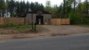
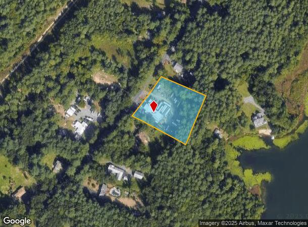
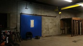
Property Record
77 Pequot Rd, Southampton, MA 01073
NEARBY LISTINGS FOR SALE OR LEASE
Property Detail
77 Pequot Rd
Springfield, MA
Hampshire
SHAM-000044-000011-A000000
Massachusetts
Autorepair
a
2025
2.07 AC
2025
Hampshire County
822500
Hartford
1,800 SF
DEMOGRAPHICS near 77 Pequot Rd
1 Mile
3 Mile
5 Mile
2024 Total Population
1,911
12,436
78,962
2029 Population
1,722
11,560
75,845
Pop Growth 2024-2029
(9.89%)
(7.04%)
(3.95%)
Average Age
44
45
41
2024 Total Households
746
4,927
32,220
HH Growth 2024-2029
(10.32%)
(7.10%)
(4.02%)
Median Household Inc
$71,093
$79,079
$59,808
Avg Household Size
2.50
2.40
2.30
2024 Avg HH Vehicles
2.00
2.00
2.00
Median Home Value
$316,860
$280,474
$275,171
Median Year Built
1977
1972
1962
Nearby Places
Map Layers
Map Styles
 Street
 Aerial
- Restaurants
- Banks
- Shops
- Fitness
- Groceries
PUBLIC TRANSPORTATION
COMMUTER RAIL
Holyoke Amtrak (Valley Flyer - Amtrak, Vermonter - Amtrak)
DRIVE
WALK
Distance
Holyoke Amtrak (Valley Flyer - Amtrak, Vermonter - Amtrak)
15 min
7.4 mi
AIRPORT
Bradley International
DRIVE
WALK
Distance
Bradley International
49 min
23.6 mi
Freight Ports
Albany, NY Port
DRIVE
WALK
Distance
Albany, NY Port
99 min
78.7 mi
SALE & LEASE HISTORY
LISTING DATE
SALE/LEASE

Jun 17, 2019
For Sale
Nearby Properties
Address
Land Use
TOTAL SIZE
Lot Size
Zoning
Address
Land Use
TOTAL SIZE
Lot Size
Zoning
71.67 AC
Address
Land Use
TOTAL SIZE
Lot Size
Zoning
133.29 AC
Address
Land Use
TOTAL SIZE
Lot Size
Zoning
3.80 AC
Address
Land Use
TOTAL SIZE
Lot Size
Zoning
74.25 AC
Address
Land Use
TOTAL SIZE
Lot Size
Zoning
143,568 SF
14.69 AC
Address
Land Use
TOTAL SIZE
Lot Size
Zoning
908.80 AC
RA
Address
Land Use
TOTAL SIZE
Lot Size
Zoning
99,230 SF
10.94 AC
Address
Land Use
TOTAL SIZE
Lot Size
Zoning
138,289 SF
22.79 AC
IG
Address
Land Use
TOTAL SIZE
Lot Size
Zoning
207,672 SF
18.62 AC
IP
Address
Land Use
TOTAL SIZE
Lot Size
Zoning
196,705 SF
21.45 AC
RM20
Address
Land Use
TOTAL SIZE
Lot Size
Zoning
77,702 SF
16.39 AC
RM20
Address
Land Use
TOTAL SIZE
Lot Size
Zoning
Address
Land Use
TOTAL SIZE
Lot Size
Zoning
21,405 SF
0.01 AC
Address
Land Use
TOTAL SIZE
Lot Size
Zoning
6.35 AC
RA
Address
Land Use
TOTAL SIZE
Lot Size
Zoning
86,524 SF
12.40 AC
Address
Land Use
TOTAL SIZE
Lot Size
Zoning
56,102 SF
11.90 AC
R-1A
Address
Land Use
TOTAL SIZE
Lot Size
Zoning
Address
Land Use
TOTAL SIZE
Lot Size
Zoning
126.15 AC
Address
Land Use
TOTAL SIZE
Lot Size
Zoning
Address
Land Use
TOTAL SIZE
Lot Size
Zoning
34,815 SF
9.29 AC
Address
Land Use
TOTAL SIZE
Lot Size
Zoning
119,200 SF
13.04 AC
IP
Address
Land Use
TOTAL SIZE
Lot Size
Zoning
538.50 AC
RA
Address
Land Use
TOTAL SIZE
Lot Size
Zoning
100,000 SF
10.51 AC
Address
Land Use
TOTAL SIZE
Lot Size
Zoning
127,500 SF
20 AC
Address
Land Use
TOTAL SIZE
Lot Size
Zoning
22,706 SF
7.02 AC
IP
Address
Land Use
TOTAL SIZE
Lot Size
Zoning
93,664 SF
4.79 AC
Address
Land Use
TOTAL SIZE
Lot Size
Zoning
21,489 SF
2.19 AC
BL
Address
Land Use
TOTAL SIZE
Lot Size
Zoning
5.97 AC
IP
Address
Land Use
TOTAL SIZE
Lot Size
Zoning
550 AC
RA
Address
Land Use
TOTAL SIZE
Lot Size
Zoning
788.74 AC
The World's #1 Commercial Real Estate Marketplace
Connect with us
© 2025 CoStar Group
The information above has been obtained from sources believed reliable. While we do not doubt its accuracy we have not verified it and make no guarantee, warranty or representation about it. It is your responsibility to independently confirm its accuracy and completeness. Any projections, opinions, assumptions, or estimates used are for example only and do not represent the current or future performance of the property. The value of this transaction to you depends on tax and other factors which should be evaluated by your tax, financial, and legal advisors. You and your advisors should conduct a careful, independent investigation of the property to determine to your satisfaction the suitability of the property for your needs.