Property Record
77 Piatt Ave, Mattoon, IL 61938
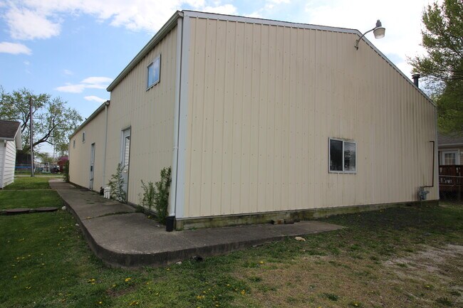

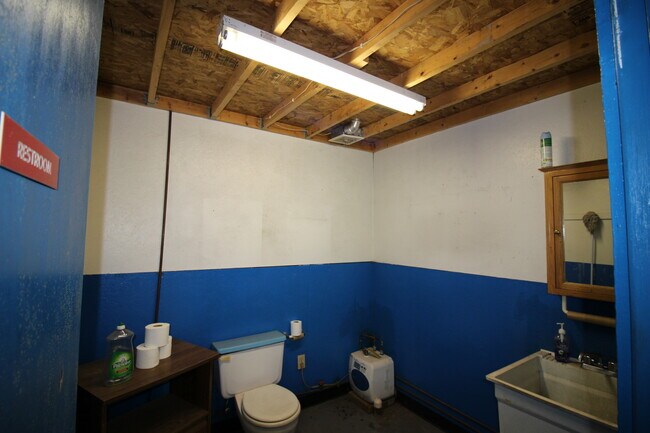
Property Detail
77 Piatt Ave
Charleston-Mattoon, IL
GRANT PARK PLACE LOT 05 BLOCK 02 COMMERCIAL REFRIGERATION
06-0-02496-000
Coles
Commercialnec
Illinois
B and X Area of moderate flood hazard, usually the area between the limits of the 100-year and 500-year floods.
5
2024
0.15 AC
2024
Effingham/Central Illinois Area
000400
Other Market Areas
2,448 SF
NEARBY LISTINGS FOR SALE OR LEASE
DEMOGRAPHICS near 77 Piatt Ave
1 mile
3 mile
5 mile
2025 Total Population
3,261
16,604
18,857
2030 Population
3,194
16,235
18,461
Pop Growth 2025-2030
(2.05%)
(2.22%)
(2.10%)
Average Age
45
42
42
2025 Total Households
1,544
7,413
8,338
HH Growth 2025-2030
(2.14%)
(2.28%)
(2.13%)
Median Household Inc
$47,500
$51,080
$54,344
Avg Household Size
2.00
2.10
2.20
2025 Avg HH Vehicles
1.00
2.00
2.00
Median Home Value
$90,962
$103,743
$114,663
Median Year Built
1962
1957
1958
Nearby Places
Map Layers
Map Styles
 Street
 Aerial
Layers
 Traffic
 Biking
Places
Listings with unknown addresses are not visible on the map
- Restaurants
- Banks
- Shops
- Fitness
- Groceries
PUBLIC TRANSPORTATION
COMMUTER RAIL
Drive
Walk
Distance
4 min
2.0 mi
SALE & LEASE HISTORY
LISTING DATE
SALE/LEASE

Sep 17, 2021
For Sale
Nearby Properties
Address
Land Use
TOTAL SIZE
Lot Size
Zoning
Address
Land Use
TOTAL SIZE
Lot Size
Zoning
Address
Land Use
TOTAL SIZE
Lot Size
Zoning
199,970 SF
24.47 AC
Address
Land Use
TOTAL SIZE
Lot Size
Zoning
75,332 SF
6.48 AC
Address
Land Use
TOTAL SIZE
Lot Size
Zoning
24,888 SF
83.61 AC
Address
Land Use
TOTAL SIZE
Lot Size
Zoning
24,943 SF
91.27 AC
Address
Land Use
TOTAL SIZE
Lot Size
Zoning
7,500 SF
26.72 AC
Address
Land Use
TOTAL SIZE
Lot Size
Zoning
Address
Land Use
TOTAL SIZE
Lot Size
Zoning
0.92 AC
Address
Land Use
TOTAL SIZE
Lot Size
Zoning
208,184 SF
30.37 AC
Address
Land Use
TOTAL SIZE
Lot Size
Zoning
39,960 SF
1.95 AC
Address
Land Use
TOTAL SIZE
Lot Size
Zoning
Address
Land Use
TOTAL SIZE
Lot Size
Zoning
59,782 SF
6.79 AC
Address
Land Use
TOTAL SIZE
Lot Size
Zoning
95,068 SF
10.13 AC
Address
Land Use
TOTAL SIZE
Lot Size
Zoning
3,360 SF
5.96 AC
Address
Land Use
TOTAL SIZE
Lot Size
Zoning
9,888 SF
1.17 AC
Address
Land Use
TOTAL SIZE
Lot Size
Zoning
31,026 SF
34.80 AC
Address
Land Use
TOTAL SIZE
Lot Size
Zoning
149,715 SF
56.72 AC
Address
Land Use
TOTAL SIZE
Lot Size
Zoning
9,644 SF
1.81 AC
Address
Land Use
TOTAL SIZE
Lot Size
Zoning
41,673 SF
5.40 AC
Address
Land Use
TOTAL SIZE
Lot Size
Zoning
Address
Land Use
TOTAL SIZE
Lot Size
Zoning
15,263 SF
2.80 AC
Address
Land Use
TOTAL SIZE
Lot Size
Zoning
2.61 AC
Address
Land Use
TOTAL SIZE
Lot Size
Zoning
230,400 SF
31.34 AC
Address
Land Use
TOTAL SIZE
Lot Size
Zoning
19,320 SF
1.44 AC
Address
Land Use
TOTAL SIZE
Lot Size
Zoning
38,486 SF
4.99 AC
Address
Land Use
TOTAL SIZE
Lot Size
Zoning
108,800 SF
19.16 AC
Address
Land Use
TOTAL SIZE
Lot Size
Zoning
68,424 SF
5 AC
Address
Land Use
TOTAL SIZE
Lot Size
Zoning
171,500 SF
11.90 AC
Address
Land Use
TOTAL SIZE
Lot Size
Zoning
25,576 SF
6.60 AC
Address
Land Use
TOTAL SIZE
Lot Size
Zoning
38,414 SF
5.21 AC
The World's #1 Commercial Real Estate Marketplace
Connect with us
© 2026 CoStar Group
The information above has been obtained from sources believed reliable. While we do not doubt its accuracy we have not verified it and make no guarantee, warranty or representation about it. It is your responsibility to independently confirm its accuracy and completeness. Any projections, opinions, assumptions, or estimates used are for example only and do not represent the current or future performance of the property. The value of this transaction to you depends on tax and other factors which should be evaluated by your tax, financial, and legal advisors. You and your advisors should conduct a careful, independent investigation of the property to determine to your satisfaction the suitability of the property for your needs.