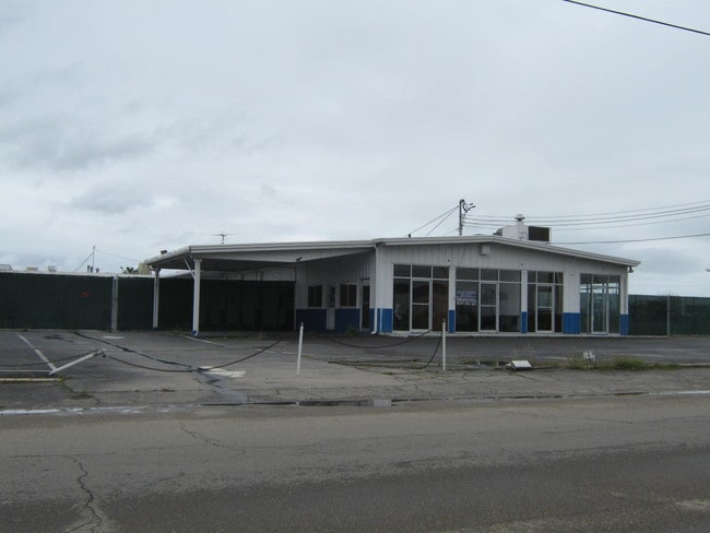
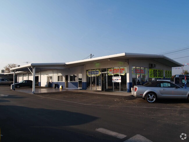
Property Record
77 S Academy Ave, Sanger, CA 93657

Property Detail
77 S Academy Ave
314-063-55S
1.27 AC NELY PAR IN NE1/4 OF NE1/4 SEC10 T14R22
Commercialacreage
FRESNO
CC
California
B and X Area of moderate flood hazard, usually the area between the limits of the 100-year and 500-year floods.
3.36 AC
2025
E Outlying Fresno Cnty
2025
Fresno
006001
Fresno, CA
6,840 SF
NEARBY LISTINGS FOR SALE OR LEASE
DEMOGRAPHICS near 77 S Academy Ave
1 mile
3 mile
5 mile
2025 Total Population
231
28,048
36,228
2030 Population
230
28,310
36,598
Pop Growth 2025-2030
(0.43%)
+ 0.93%
+ 1.02%
Average Age
39
36
36
2025 Total Households
73
8,082
10,644
HH Growth 2025-2030
0.00%
+ 0.88%
+ 0.98%
Median Household Inc
$81,944
$76,881
$81,604
Avg Household Size
3.10
3.40
3.30
2025 Avg HH Vehicles
2.00
2.00
2.00
Median Home Value
$570,000
$384,531
$431,895
Median Year Built
1982
1979
1979
Nearby Places
Map Layers
Map Styles
 Street
 Aerial
Transit
 Traffic
 Biking
Places
Listings with unknown addresses are not visible on the map
- Restaurants
- Banks
- Shops
- Fitness
- Groceries
PUBLIC TRANSPORTATION
AIRPORT
Fresno Yosemite International
Drive
Walk
Distance
Fresno Yosemite International
15 min
11.1 mi
Freight Ports
Port of Stockton
Drive
Walk
Distance
Port of Stockton
166 min
141.1 mi
Nearby Properties
Address
Land Use
TOTAL SIZE
Lot Size
Zoning
Address
Land Use
TOTAL SIZE
Lot Size
Zoning
119,762 SF
7.67 AC
M1
Address
Land Use
TOTAL SIZE
Lot Size
Zoning
109,374 SF
8.61 AC
RM25
Address
Land Use
TOTAL SIZE
Lot Size
Zoning
165,948 SF
16.88 AC
C2
Address
Land Use
TOTAL SIZE
Lot Size
Zoning
71,102 SF
3.56 AC
Address
Land Use
TOTAL SIZE
Lot Size
Zoning
87,150 SF
7.26 AC
RM25
Address
Land Use
TOTAL SIZE
Lot Size
Zoning
67,266 SF
3.35 AC
Address
Land Use
TOTAL SIZE
Lot Size
Zoning
51,204 SF
3.61 AC
RS3
Address
Land Use
TOTAL SIZE
Lot Size
Zoning
158.81 AC
AE20
Address
Land Use
TOTAL SIZE
Lot Size
Zoning
54,026 SF
10.83 AC
MH
Address
Land Use
TOTAL SIZE
Lot Size
Zoning
54,050 SF
6.27 AC
CP
Address
Land Use
TOTAL SIZE
Lot Size
Zoning
44,811 SF
4.53 AC
Address
Land Use
TOTAL SIZE
Lot Size
Zoning
74,874 SF
8.52 AC
RM25
Address
Land Use
TOTAL SIZE
Lot Size
Zoning
55,440 SF
2.55 AC
R4
Address
Land Use
TOTAL SIZE
Lot Size
Zoning
924 SF
154 AC
AE20
Address
Land Use
TOTAL SIZE
Lot Size
Zoning
46,912 SF
2.82 AC
R2
Address
Land Use
TOTAL SIZE
Lot Size
Zoning
9,190 SF
0.43 AC
RM25
Address
Land Use
TOTAL SIZE
Lot Size
Zoning
33,524 SF
36.90 AC
AE20
Address
Land Use
TOTAL SIZE
Lot Size
Zoning
15,403 SF
0.34 AC
CR
Address
Land Use
TOTAL SIZE
Lot Size
Zoning
13,717 SF
1.03 AC
C2
Address
Land Use
TOTAL SIZE
Lot Size
Zoning
33,480 SF
1.81 AC
RM2
Address
Land Use
TOTAL SIZE
Lot Size
Zoning
12,527 SF
3.97 AC
C2
Address
Land Use
TOTAL SIZE
Lot Size
Zoning
14,888 SF
1.25 AC
CP
Address
Land Use
TOTAL SIZE
Lot Size
Zoning
73,577 SF
25.18 AC
AE20
Address
Land Use
TOTAL SIZE
Lot Size
Zoning
29,641 SF
9.58 AC
R16
Address
Land Use
TOTAL SIZE
Lot Size
Zoning
23,501 SF
1.89 AC
C2
Address
Land Use
TOTAL SIZE
Lot Size
Zoning
6,500 SF
0.65 AC
CP
Address
Land Use
TOTAL SIZE
Lot Size
Zoning
1,058 SF
77.22 AC
AE20
Address
Land Use
TOTAL SIZE
Lot Size
Zoning
5,197 SF
0.59 AC
ML
Address
Land Use
TOTAL SIZE
Lot Size
Zoning
18,900 SF
1.64 AC
CN
The World's #1 Commercial Real Estate Marketplace
Connect with us
© 2026 CoStar Group
The information above has been obtained from sources believed reliable. While we do not doubt its accuracy we have not verified it and make no guarantee, warranty or representation about it. It is your responsibility to independently confirm its accuracy and completeness. Any projections, opinions, assumptions, or estimates used are for example only and do not represent the current or future performance of the property. The value of this transaction to you depends on tax and other factors which should be evaluated by your tax, financial, and legal advisors. You and your advisors should conduct a careful, independent investigation of the property to determine to your satisfaction the suitability of the property for your needs.