No Photo
Property Record
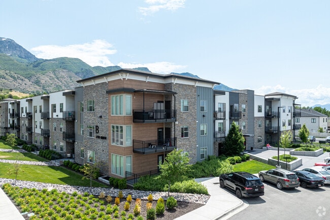
77 W 4800 N, Provo, UT 84604


Property Detail
77 W 4800 N
Provo-Orem-Lehi, UT
LOT 2, PLAT A, PROVO APARTMENTS AT 4800 NORTH SUB AREA 6.490 AC.
49-894-0002
Utah
Apartment
Utah
2024
2
2025
6.49 AC
001401
River Bottoms
311,697 SF
Salt Lake City
NEARBY LISTINGS FOR SALE OR LEASE
DEMOGRAPHICS near 77 W 4800 N
1 mile
3 mile
5 mile
2025 Total Population
9,825
99,573
241,418
2030 Population
10,784
108,854
264,982
Pop Growth 2025-2030
+ 9.76%
+ 9.32%
+ 9.76%
Average Age
37
33
31
2025 Total Households
2,738
31,062
73,713
HH Growth 2025-2030
+ 10.56%
+ 10.22%
+ 10.79%
Median Household Inc
$122,675
$84,122
$77,293
Avg Household Size
3.40
3.10
3.00
2025 Avg HH Vehicles
2.00
2.00
2.00
Median Home Value
$729,560
$597,900
$559,871
Median Year Built
1987
1984
1990
Nearby Places
Map Layers
Map Styles
 Street
 Aerial
Layers
 Traffic
 Biking
Places
Listings with unknown addresses are not visible on the map
- Restaurants
- Banks
- Shops
- Fitness
- Groceries
PUBLIC TRANSPORTATION
COMMUTER RAIL
Vineyard Station (FrontRunner - Utah Transit Authority (UTA))
Drive
Walk
Distance
Vineyard Station (FrontRunner - Utah Transit Authority (UTA))
12 min
5.6 mi
Orem Central Station (FrontRunner - Utah Transit Authority (UTA))
Drive
Walk
Distance
Orem Central Station (FrontRunner - Utah Transit Authority (UTA))
13 min
6.3 mi
AIRPORT
Provo Municipal
Drive
Walk
Distance
Provo Municipal
17 min
10.0 mi
Freight Ports
Port of Stockton
Drive
Walk
Distance
Port of Stockton
757 min
736.1 mi
Nearby Properties
Address
Land Use
TOTAL SIZE
Lot Size
Zoning
Address
Land Use
TOTAL SIZE
Lot Size
Zoning
1,003,185 SF
9.57 AC
Address
Land Use
TOTAL SIZE
Lot Size
Zoning
623,237 SF
14.06 AC
Address
Land Use
TOTAL SIZE
Lot Size
Zoning
530,326 SF
8.14 AC
Address
Land Use
TOTAL SIZE
Lot Size
Zoning
627,022 SF
9.16 AC
Address
Land Use
TOTAL SIZE
Lot Size
Zoning
310,818 SF
1.17 AC
Address
Land Use
TOTAL SIZE
Lot Size
Zoning
219,346 SF
2.20 AC
Address
Land Use
TOTAL SIZE
Lot Size
Zoning
199,119 SF
17.18 AC
Address
Land Use
TOTAL SIZE
Lot Size
Zoning
323,674 SF
13.81 AC
Address
Land Use
TOTAL SIZE
Lot Size
Zoning
122,784 SF
12.46 AC
Address
Land Use
TOTAL SIZE
Lot Size
Zoning
245,657 SF
5.60 AC
Address
Land Use
TOTAL SIZE
Lot Size
Zoning
212,820 SF
12.90 AC
Address
Land Use
TOTAL SIZE
Lot Size
Zoning
401,381 SF
3.50 AC
Address
Land Use
TOTAL SIZE
Lot Size
Zoning
154,685 SF
13.20 AC
Address
Land Use
TOTAL SIZE
Lot Size
Zoning
139,462 SF
3.93 AC
Address
Land Use
TOTAL SIZE
Lot Size
Zoning
124,242 SF
9.33 AC
Address
Land Use
TOTAL SIZE
Lot Size
Zoning
179,347 SF
13.55 AC
Address
Land Use
TOTAL SIZE
Lot Size
Zoning
300,810 SF
7.32 AC
Address
Land Use
TOTAL SIZE
Lot Size
Zoning
176,127 SF
9.29 AC
Address
Land Use
TOTAL SIZE
Lot Size
Zoning
4,053 SF
18.21 AC
Address
Land Use
TOTAL SIZE
Lot Size
Zoning
206,778 SF
5.11 AC
Address
Land Use
TOTAL SIZE
Lot Size
Zoning
170,536 SF
2.16 AC
Address
Land Use
TOTAL SIZE
Lot Size
Zoning
204,655 SF
8.10 AC
Address
Land Use
TOTAL SIZE
Lot Size
Zoning
211,929 SF
1.30 AC
Address
Land Use
TOTAL SIZE
Lot Size
Zoning
9,326 SF
5.19 AC
Address
Land Use
TOTAL SIZE
Lot Size
Zoning
111,474 SF
8.98 AC
Address
Land Use
TOTAL SIZE
Lot Size
Zoning
124,183 SF
4.28 AC
Address
Land Use
TOTAL SIZE
Lot Size
Zoning
83,568 SF
2 AC
Address
Land Use
TOTAL SIZE
Lot Size
Zoning
87,031 SF
5.69 AC
Address
Land Use
TOTAL SIZE
Lot Size
Zoning
123,663 SF
5.31 AC
The World's #1 Commercial Real Estate Marketplace
Connect with us
© 2026 CoStar Group
The information above has been obtained from sources believed reliable. While we do not doubt its accuracy we have not verified it and make no guarantee, warranty or representation about it. It is your responsibility to independently confirm its accuracy and completeness. Any projections, opinions, assumptions, or estimates used are for example only and do not represent the current or future performance of the property. The value of this transaction to you depends on tax and other factors which should be evaluated by your tax, financial, and legal advisors. You and your advisors should conduct a careful, independent investigation of the property to determine to your satisfaction the suitability of the property for your needs.