Property Record
77 W Camp Rd, Saugerties, NY 12477

NEARBY LISTINGS FOR SALE OR LEASE
-
-
View all Saugerties listings for sale on LoopNet.com
Property Detail
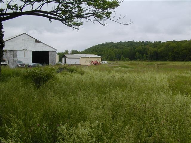
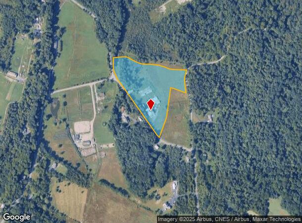
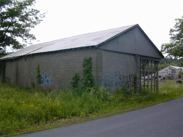
77 W Camp Rd
4889-009.003-0003-028.100-0000
Ulster
Warehouse
New York
X
28.100
36111C0115E
9.30 AC
2025
Hudson Valley Area
2024
Other Market Areas
950400
Kingston, NY
6,504 SF
DEMOGRAPHICS near 77 W Camp Rd
1 Mile
3 Mile
5 Mile
2024 Total Population
415
3,491
15,584
2029 Population
412
3,467
15,597
Pop Growth 2024-2029
(0.72%)
(0.69%)
+ 0.08%
Average Age
45
45
45
2024 Total Households
172
1,479
6,785
HH Growth 2024-2029
(0.58%)
(0.74%)
+ 0.06%
Median Household Inc
$61,500
$83,214
$71,287
Avg Household Size
2.30
2.30
2.20
2024 Avg HH Vehicles
2.00
2.00
2.00
Median Home Value
$248,863
$317,347
$301,117
Median Year Built
1953
1957
1957
Nearby Places
- Restaurants
- Banks
- Shops
- Fitness
- Groceries
Nearby Properties
Address
Land Use
TOTAL SIZE
Lot Size
Zoning
Address
Land Use
TOTAL SIZE
Lot Size
Zoning
88,216 SF
21.30 AC
RA2
Address
Land Use
TOTAL SIZE
Lot Size
Zoning
59,628 SF
688.77 AC
06 - INDUS
Address
Land Use
TOTAL SIZE
Lot Size
Zoning
31,824 SF
84 AC
LDR
Address
Land Use
TOTAL SIZE
Lot Size
Zoning
33.30 AC
04 - FARM
Address
Land Use
TOTAL SIZE
Lot Size
Zoning
81,250 SF
17.50 AC
06 - INDUS
Address
Land Use
TOTAL SIZE
Lot Size
Zoning
2,232 SF
82.20 AC
02 - SINGL
Address
Land Use
TOTAL SIZE
Lot Size
Zoning
32,730 SF
9.70 AC
04 - FARM
Address
Land Use
TOTAL SIZE
Lot Size
Zoning
14,184 SF
73.50 AC
02 - SINGL
Address
Land Use
TOTAL SIZE
Lot Size
Zoning
125.80 AC
04 - FARM
Address
Land Use
TOTAL SIZE
Lot Size
Zoning
10,438 SF
15.40 AC
02 - SINGL
Address
Land Use
TOTAL SIZE
Lot Size
Zoning
18.60 AC
R2
Address
Land Use
TOTAL SIZE
Lot Size
Zoning
3,347 SF
9.60 AC
RA2
Address
Land Use
TOTAL SIZE
Lot Size
Zoning
10,422 SF
473.53 AC
06 - INDUS
Address
Land Use
TOTAL SIZE
Lot Size
Zoning
5,780 SF
1,368.80 AC
06 - INDUS
Address
Land Use
TOTAL SIZE
Lot Size
Zoning
25.10 AC
04 - FARM
Address
Land Use
TOTAL SIZE
Lot Size
Zoning
3,925 SF
7.80 AC
07 - MIXED
Address
Land Use
TOTAL SIZE
Lot Size
Zoning
14,000 SF
9.96 AC
06 - INDUS
Address
Land Use
TOTAL SIZE
Lot Size
Zoning
5,100 SF
5.10 AC
05 - COMME
Address
Land Use
TOTAL SIZE
Lot Size
Zoning
3,954 SF
2.81 AC
RA2
Address
Land Use
TOTAL SIZE
Lot Size
Zoning
2,184 SF
5.53 AC
RA2
Address
Land Use
TOTAL SIZE
Lot Size
Zoning
1,902 SF
9 AC
LDRLB
Address
Land Use
TOTAL SIZE
Lot Size
Zoning
40.40 AC
Address
Land Use
TOTAL SIZE
Lot Size
Zoning
3,360 SF
10.30 AC
06 - INDUS
Address
Land Use
TOTAL SIZE
Lot Size
Zoning
5,984 SF
1.60 AC
RA2
Address
Land Use
TOTAL SIZE
Lot Size
Zoning
33,415 SF
1.20 AC
RA2
Address
Land Use
TOTAL SIZE
Lot Size
Zoning
36.33 AC
07 - MIXED
Address
Land Use
TOTAL SIZE
Lot Size
Zoning
51.60 AC
07 - MIXED
Address
Land Use
TOTAL SIZE
Lot Size
Zoning
7,560 SF
82.40 AC
02 - SINGL
Address
Land Use
TOTAL SIZE
Lot Size
Zoning
2,610 SF
0.67 AC
RA2
Address
Land Use
TOTAL SIZE
Lot Size
Zoning
15,000 SF
17.70 AC
02 - SINGL
The World's #1 Commercial Real Estate Marketplace
Connect with us
© 2025 CoStar Group
The information above has been obtained from sources believed reliable. While we do not doubt its accuracy we have not verified it and make no guarantee, warranty or representation about it. It is your responsibility to independently confirm its accuracy and completeness. Any projections, opinions, assumptions, or estimates used are for example only and do not represent the current or future performance of the property. The value of this transaction to you depends on tax and other factors which should be evaluated by your tax, financial, and legal advisors. You and your advisors should conduct a careful, independent investigation of the property to determine to your satisfaction the suitability of the property for your needs.