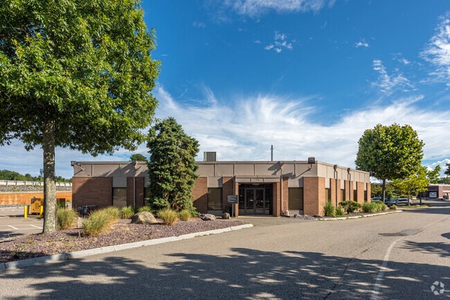
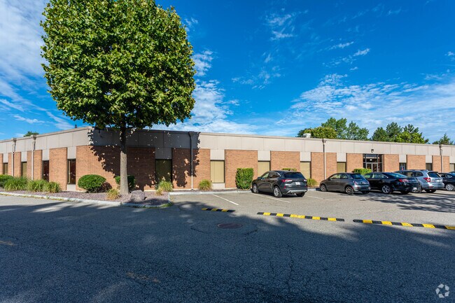
Property Record
770 Dedham St, Canton, MA 02021

Current Lease Availabilities
Property Detail
770 Dedham St
Officebuilding
Norfolk
6
Massachusetts
B and X Area of moderate flood hazard, usually the area between the limits of the 100-year and 500-year floods.
0.77 AC
2025
Route 1 South
2025
Boston
415101
Boston-Cambridge-Newton, MA-NH
14,944 SF
CANT-000033-000000-000003
NEARBY LISTINGS FOR SALE OR LEASE
DEMOGRAPHICS near 770 Dedham St
1 mile
3 mile
5 mile
2025 Total Population
1,425
52,282
164,865
2030 Population
1,469
53,552
168,592
Pop Growth 2025-2030
+ 3.09%
+ 2.43%
+ 2.26%
Average Age
42
43
42
2025 Total Households
495
20,380
63,130
HH Growth 2025-2030
+ 3.23%
+ 2.57%
+ 2.37%
Median Household Inc
$191,802
$125,929
$118,198
Avg Household Size
2.80
2.50
2.50
2025 Avg HH Vehicles
2.00
2.00
2.00
Median Home Value
$846,804
$753,874
$733,483
Median Year Built
1967
1964
1963
Nearby Places
Map Layers
Map Styles
 Street
 Aerial
Transit
 Traffic
 Biking
Places
Listings with unknown addresses are not visible on the map
- Restaurants
- Banks
- Shops
- Fitness
- Groceries
PUBLIC TRANSPORTATION
COMMUTER RAIL
Route 128 (Providence/Stoughton Line - Massachusetts Bay Transportation Authority Commuter Rail (Purple Line))
Drive
Walk
Distance
Route 128 (Providence/Stoughton Line - Massachusetts Bay Transportation Authority Commuter Rail (Purple Line))
5 min
1.8 mi
Canton Junction (Providence/Stoughton Line - Massachusetts Bay Transportation Authority Commuter Rail (Purple Line))
Drive
Walk
Distance
Canton Junction (Providence/Stoughton Line - Massachusetts Bay Transportation Authority Commuter Rail (Purple Line))
7 min
2.9 mi
AIRPORT
General Edward Lawrence Logan International
Drive
Walk
Distance
General Edward Lawrence Logan International
34 min
21.8 mi
Rhode Island Tf Green International
Drive
Walk
Distance
Rhode Island Tf Green International
56 min
39.9 mi
Nearby Properties
Address
Land Use
TOTAL SIZE
Lot Size
Zoning
Address
Land Use
TOTAL SIZE
Lot Size
Zoning
380,030 SF
24.87 AC
Address
Land Use
TOTAL SIZE
Lot Size
Zoning
413,827 SF
9.49 AC
RDO
Address
Land Use
TOTAL SIZE
Lot Size
Zoning
11.66 AC
LM
Address
Land Use
TOTAL SIZE
Lot Size
Zoning
380,030 SF
24.87 AC
Address
Land Use
TOTAL SIZE
Lot Size
Zoning
45,836 SF
23.25 AC
Address
Land Use
TOTAL SIZE
Lot Size
Zoning
226,304 SF
2.89 AC
Address
Land Use
TOTAL SIZE
Lot Size
Zoning
18,451 SF
19.07 AC
Address
Land Use
TOTAL SIZE
Lot Size
Zoning
351,699 SF
27.36 AC
Address
Land Use
TOTAL SIZE
Lot Size
Zoning
5,349 SF
8.74 AC
Address
Land Use
TOTAL SIZE
Lot Size
Zoning
132,917 SF
24 AC
RE
Address
Land Use
TOTAL SIZE
Lot Size
Zoning
543,189 SF
22.90 AC
6
Address
Land Use
TOTAL SIZE
Lot Size
Zoning
254,787 SF
55.40 AC
Address
Land Use
TOTAL SIZE
Lot Size
Zoning
267,103 SF
20.23 AC
10
Address
Land Use
TOTAL SIZE
Lot Size
Zoning
180,022 SF
3.74 AC
Address
Land Use
TOTAL SIZE
Lot Size
Zoning
45.72 AC
LM
Address
Land Use
TOTAL SIZE
Lot Size
Zoning
154,871 SF
34.30 AC
10
Address
Land Use
TOTAL SIZE
Lot Size
Zoning
242,198 SF
53.28 AC
Address
Land Use
TOTAL SIZE
Lot Size
Zoning
198,120 SF
51 AC
3
Address
Land Use
TOTAL SIZE
Lot Size
Zoning
81,796 SF
11.87 AC
Address
Land Use
TOTAL SIZE
Lot Size
Zoning
195,690 SF
14.98 AC
NV
Address
Land Use
TOTAL SIZE
Lot Size
Zoning
185,592 SF
37.21 AC
Address
Land Use
TOTAL SIZE
Lot Size
Zoning
294,771 SF
17.85 AC
Address
Land Use
TOTAL SIZE
Lot Size
Zoning
62,043 SF
10.68 AC
6
Address
Land Use
TOTAL SIZE
Lot Size
Zoning
150,802 SF
3.09 AC
LM
Address
Land Use
TOTAL SIZE
Lot Size
Zoning
170,482 SF
18.60 AC
Address
Land Use
TOTAL SIZE
Lot Size
Zoning
263,007 SF
8.11 AC
Address
Land Use
TOTAL SIZE
Lot Size
Zoning
160,716 SF
18.87 AC
11
Address
Land Use
TOTAL SIZE
Lot Size
Zoning
329,800 SF
18.49 AC
Address
Land Use
TOTAL SIZE
Lot Size
Zoning
13,272 SF
46.37 AC
5
Address
Land Use
TOTAL SIZE
Lot Size
Zoning
130,356 SF
14.70 AC
9
The World's #1 Commercial Real Estate Marketplace
Connect with us
© 2026 CoStar Group
The information above has been obtained from sources believed reliable. While we do not doubt its accuracy we have not verified it and make no guarantee, warranty or representation about it. It is your responsibility to independently confirm its accuracy and completeness. Any projections, opinions, assumptions, or estimates used are for example only and do not represent the current or future performance of the property. The value of this transaction to you depends on tax and other factors which should be evaluated by your tax, financial, and legal advisors. You and your advisors should conduct a careful, independent investigation of the property to determine to your satisfaction the suitability of the property for your needs.