Property Record
770 E Sixth St, Beaumont, CA 92223
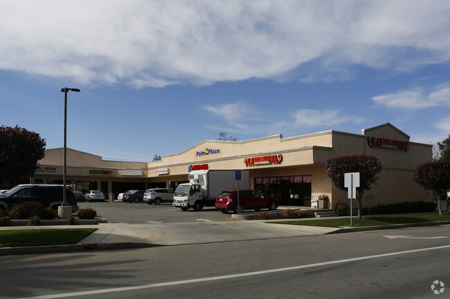
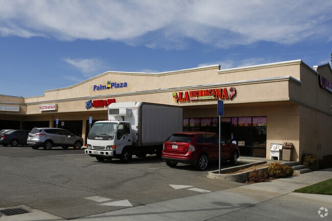
Property Detail
770 E Sixth St
418-051-006
POR LOTS 13 & 15 BLK 88 MB 006/016 SB AMENDED MAP OF THE TOWN OF BEAUMONT
Regionalshoppingcenterormallwithanchorstore
Riverside
C2
California
AO River or stream flood hazard areas, and areas with a 1% or greater chance of shallow flooding each year. These areas have a 26% chance of flooding over the life of a 30-year mortgage.
15
2024
0.43 AC
2025
Beaumont/Hemet
044000
Inland Empire (California)
8,799 SF
Riverside-San Bernardino-Ontario, CA
NEARBY LISTINGS FOR SALE OR LEASE
DEMOGRAPHICS near 770 E Sixth St
1 mile
3 mile
5 mile
2025 Total Population
11,422
58,517
84,115
2030 Population
11,706
60,524
87,299
Pop Growth 2025-2030
+ 2.49%
+ 3.43%
+ 3.79%
Average Age
35
42
42
2025 Total Households
3,470
20,604
29,095
HH Growth 2025-2030
+ 2.10%
+ 2.82%
+ 3.19%
Median Household Inc
$77,107
$88,001
$90,408
Avg Household Size
3.20
2.80
2.80
2025 Avg HH Vehicles
2.00
2.00
2.00
Median Home Value
$432,820
$474,523
$479,983
Median Year Built
1977
2001
2001
Nearby Places
Map Layers
Map Styles
 Street
 Aerial
Transit
 Traffic
 Biking
Places
Listings with unknown addresses are not visible on the map
- Restaurants
- Banks
- Shops
- Fitness
- Groceries
PUBLIC TRANSPORTATION
AIRPORT
Palm Springs International
Drive
Walk
Distance
Palm Springs International
38 min
31.8 mi
Freight Ports
Port of Long Beach
Drive
Walk
Distance
Port of Long Beach
103 min
80.7 mi
Nearby Properties
Address
Land Use
TOTAL SIZE
Lot Size
Zoning
Address
Land Use
TOTAL SIZE
Lot Size
Zoning
2,643,646 SF
59.98 AC
Address
Land Use
TOTAL SIZE
Lot Size
Zoning
600,000 SF
30.81 AC
RA
Address
Land Use
TOTAL SIZE
Lot Size
Zoning
146,056 SF
15.95 AC
Address
Land Use
TOTAL SIZE
Lot Size
Zoning
444,455 SF
19.89 AC
IND
Address
Land Use
TOTAL SIZE
Lot Size
Zoning
95,590 SF
7.48 AC
Address
Land Use
TOTAL SIZE
Lot Size
Zoning
153,303 SF
11.08 AC
Address
Land Use
TOTAL SIZE
Lot Size
Zoning
30.91 AC
Address
Land Use
TOTAL SIZE
Lot Size
Zoning
211,062 SF
11.02 AC
Address
Land Use
TOTAL SIZE
Lot Size
Zoning
216,071 SF
21.90 AC
Address
Land Use
TOTAL SIZE
Lot Size
Zoning
174,418 SF
46.93 AC
Address
Land Use
TOTAL SIZE
Lot Size
Zoning
116,175 SF
4.86 AC
RA
Address
Land Use
TOTAL SIZE
Lot Size
Zoning
44,506 SF
2.35 AC
Address
Land Use
TOTAL SIZE
Lot Size
Zoning
97,103 SF
8 AC
Address
Land Use
TOTAL SIZE
Lot Size
Zoning
39,866 SF
3.55 AC
Address
Land Use
TOTAL SIZE
Lot Size
Zoning
43,105 SF
4.23 AC
Address
Land Use
TOTAL SIZE
Lot Size
Zoning
42,325 SF
2.31 AC
Address
Land Use
TOTAL SIZE
Lot Size
Zoning
44,506 SF
2.84 AC
Address
Land Use
TOTAL SIZE
Lot Size
Zoning
141,286 SF
10.72 AC
Address
Land Use
TOTAL SIZE
Lot Size
Zoning
103,087 SF
8.52 AC
Address
Land Use
TOTAL SIZE
Lot Size
Zoning
27,359 SF
1.97 AC
C2
Address
Land Use
TOTAL SIZE
Lot Size
Zoning
64,465 SF
3.56 AC
Address
Land Use
TOTAL SIZE
Lot Size
Zoning
127,688 SF
6.75 AC
IND
Address
Land Use
TOTAL SIZE
Lot Size
Zoning
90,184 SF
4.81 AC
C1
Address
Land Use
TOTAL SIZE
Lot Size
Zoning
87,015 SF
6.90 AC
C-HS
Address
Land Use
TOTAL SIZE
Lot Size
Zoning
42,602 SF
3.91 AC
RA
Address
Land Use
TOTAL SIZE
Lot Size
Zoning
59,641 SF
2.02 AC
CPS
Address
Land Use
TOTAL SIZE
Lot Size
Zoning
24,542 SF
3.02 AC
The World's #1 Commercial Real Estate Marketplace
Connect with us
© 2026 CoStar Group
The information above has been obtained from sources believed reliable. While we do not doubt its accuracy we have not verified it and make no guarantee, warranty or representation about it. It is your responsibility to independently confirm its accuracy and completeness. Any projections, opinions, assumptions, or estimates used are for example only and do not represent the current or future performance of the property. The value of this transaction to you depends on tax and other factors which should be evaluated by your tax, financial, and legal advisors. You and your advisors should conduct a careful, independent investigation of the property to determine to your satisfaction the suitability of the property for your needs.