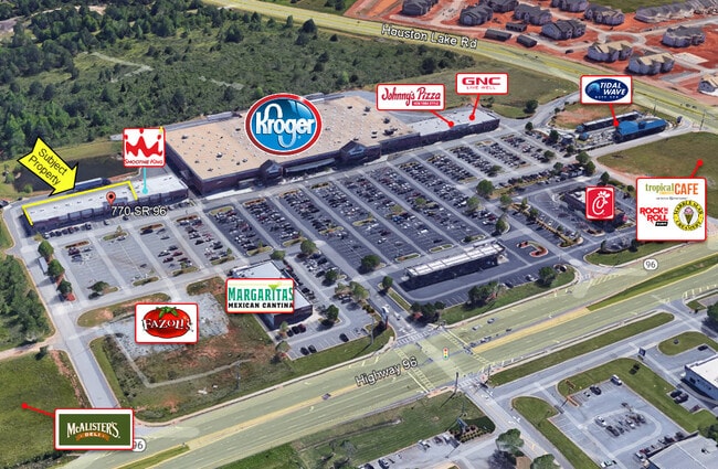
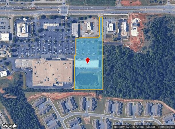
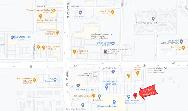
Property Record
770 Highway 96, Bonaire, GA 31005
NEARBY LISTINGS FOR SALE OR LEASE
Property Detail
770 Highway 96
Warner Robins, GA
Hwy 96 Houston Lake Rd
0W1110119000
PARCEL 1B 4.541 ACRES 188/10TH
Gymhealthspa
Houston
X
Georgia
13225C0150C
188
2024
4.54 AC
2024
Perry/Warner Robins
021108
Other Market Areas
13,213 SF
DEMOGRAPHICS near 770 Highway 96
1 Mile
3 Mile
5 Mile
2024 Total Population
5,865
43,430
100,998
2029 Population
6,376
47,378
110,763
Pop Growth 2024-2029
+ 8.71%
+ 9.09%
+ 9.67%
Average Age
37
37
37
2024 Total Households
2,232
16,289
37,948
HH Growth 2024-2029
+ 8.42%
+ 8.93%
+ 9.45%
Median Household Inc
$90,630
$94,998
$84,069
Avg Household Size
2.60
2.60
2.60
2024 Avg HH Vehicles
2.00
2.00
2.00
Median Home Value
$187,641
$183,504
$184,774
Median Year Built
1998
1998
1996
Nearby Places
Map Layers
Map Styles
 Street
 Aerial
- Restaurants
- Banks
- Shops
- Fitness
- Groceries
SALE & LEASE HISTORY
LISTING DATE
SALE/LEASE

Jun 05, 2023
For Lease
Apr 08, 2025
For Lease
Nearby Properties
Address
Land Use
TOTAL SIZE
Lot Size
Zoning
Address
Land Use
TOTAL SIZE
Lot Size
Zoning
80,000 SF
46.13 AC
R2
Address
Land Use
TOTAL SIZE
Lot Size
Zoning
15,006 SF
30.30 AC
R4
Address
Land Use
TOTAL SIZE
Lot Size
Zoning
5,400 SF
22.93 AC
R4
Address
Land Use
TOTAL SIZE
Lot Size
Zoning
9,828 SF
18.63 AC
R4
Address
Land Use
TOTAL SIZE
Lot Size
Zoning
5,440 SF
36.50 AC
R4
Address
Land Use
TOTAL SIZE
Lot Size
Zoning
10,568 SF
35.44 AC
R4
Address
Land Use
TOTAL SIZE
Lot Size
Zoning
100,320 SF
26.91 AC
C2
Address
Land Use
TOTAL SIZE
Lot Size
Zoning
26,271 SF
17.43 AC
C2
Address
Land Use
TOTAL SIZE
Lot Size
Zoning
273,000 SF
63.42 AC
C2
Address
Land Use
TOTAL SIZE
Lot Size
Zoning
219,205 SF
26.17 AC
R2
Address
Land Use
TOTAL SIZE
Lot Size
Zoning
112,824 SF
13.07 AC
C2
Address
Land Use
TOTAL SIZE
Lot Size
Zoning
112,824 SF
Address
Land Use
TOTAL SIZE
Lot Size
Zoning
112,824 SF
Address
Land Use
TOTAL SIZE
Lot Size
Zoning
28,668 SF
17.38 AC
R4 C2
Address
Land Use
TOTAL SIZE
Lot Size
Zoning
158,300 SF
43.81 AC
GU
Address
Land Use
TOTAL SIZE
Lot Size
Zoning
16,570 SF
15.62 AC
R4
Address
Land Use
TOTAL SIZE
Lot Size
Zoning
67,732 SF
25 AC
R4
Address
Land Use
TOTAL SIZE
Lot Size
Zoning
134,400 SF
22.43 AC
R1
Address
Land Use
TOTAL SIZE
Lot Size
Zoning
76,751 SF
26.32 AC
R1
Address
Land Use
TOTAL SIZE
Lot Size
Zoning
122,858 SF
8.64 AC
C2
Address
Land Use
TOTAL SIZE
Lot Size
Zoning
100,500 SF
19.64 AC
R2
Address
Land Use
TOTAL SIZE
Lot Size
Zoning
78,956 SF
9.05 AC
C2
Address
Land Use
TOTAL SIZE
Lot Size
Zoning
100,500 SF
19.74 AC
R2
Address
Land Use
TOTAL SIZE
Lot Size
Zoning
38,112 SF
8.84 AC
R4
Address
Land Use
TOTAL SIZE
Lot Size
Zoning
6,624 SF
8.08 AC
R4
Address
Land Use
TOTAL SIZE
Lot Size
Zoning
6,574 SF
10.14 AC
R4
Address
Land Use
TOTAL SIZE
Lot Size
Zoning
85,580 SF
33.60 AC
R2
Address
Land Use
TOTAL SIZE
Lot Size
Zoning
4,592 SF
10.20 AC
R4
Address
Land Use
TOTAL SIZE
Lot Size
Zoning
138,518 SF
14.72 AC
C2
Address
Land Use
TOTAL SIZE
Lot Size
Zoning
79,638 SF
6.65 AC
C2
The World's #1 Commercial Real Estate Marketplace
Connect with us
© 2025 CoStar Group
The information above has been obtained from sources believed reliable. While we do not doubt its accuracy we have not verified it and make no guarantee, warranty or representation about it. It is your responsibility to independently confirm its accuracy and completeness. Any projections, opinions, assumptions, or estimates used are for example only and do not represent the current or future performance of the property. The value of this transaction to you depends on tax and other factors which should be evaluated by your tax, financial, and legal advisors. You and your advisors should conduct a careful, independent investigation of the property to determine to your satisfaction the suitability of the property for your needs.