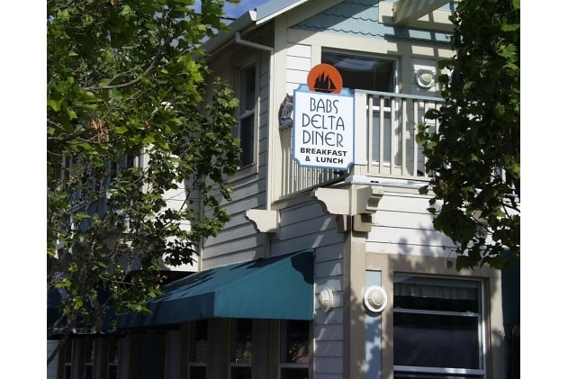
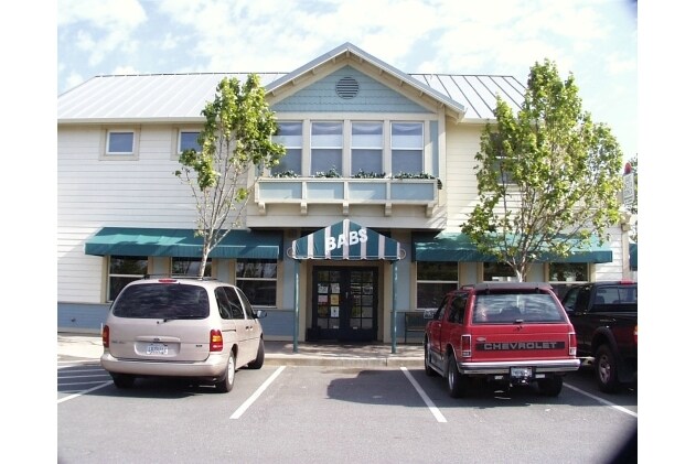
Property Record
770 Kellogg St, Suisun City, CA 94585


Property Detail
770 Kellogg St
0032-142-180
BK-BG 00-00
Miscresidentialimprovement
Solano
AE The base floodplain where base flood elevations are provided. AE Zones are now used on new format FIRMs instead of A1-A30 Zones.
California
2024
0.08 AC
2025
Fairfield
252702
North Bay/Santa Rosa
3,263 SF
Vallejo, CA
NEARBY LISTINGS FOR SALE OR LEASE
DEMOGRAPHICS near 770 Kellogg St
1 mile
3 mile
5 mile
2025 Total Population
8,003
85,453
121,487
2030 Population
8,071
85,918
122,345
Pop Growth 2025-2030
+ 0.85%
+ 0.54%
+ 0.71%
Average Age
38
38
39
2025 Total Households
2,733
27,689
40,276
HH Growth 2025-2030
+ 0.91%
+ 0.56%
+ 0.71%
Median Household Inc
$61,604
$85,061
$96,321
Avg Household Size
2.80
3.00
2.90
2025 Avg HH Vehicles
2.00
2.00
2.00
Median Home Value
$491,201
$574,550
$648,135
Median Year Built
1973
1977
1981
Nearby Places
Map Layers
Map Styles
 Street
 Aerial
Layers
 Traffic
 Biking
Places
Listings with unknown addresses are not visible on the map
- Restaurants
- Banks
- Shops
- Fitness
- Groceries
PUBLIC TRANSPORTATION
COMMUTER RAIL
Suisun-Fairfield (Capitol Corridor - Capitol Corridor Joint Powers Authority)
Drive
Walk
Distance
Suisun-Fairfield (Capitol Corridor - Capitol Corridor Joint Powers Authority)
1 min
9 min
0.5 mi
Fairfield-Vacaville Amtrak Station (Capitol Corridor - Amtrak)
Drive
Walk
Distance
Fairfield-Vacaville Amtrak Station (Capitol Corridor - Amtrak)
14 min
7.2 mi
Freight Ports
Port of Richmond
Drive
Walk
Distance
Port of Richmond
50 min
37.0 mi
Nearby Properties
Address
Land Use
TOTAL SIZE
Lot Size
Zoning
Address
Land Use
TOTAL SIZE
Lot Size
Zoning
75.45 AC
Address
Land Use
TOTAL SIZE
Lot Size
Zoning
Address
Land Use
TOTAL SIZE
Lot Size
Zoning
317,493 SF
21.54 AC
Address
Land Use
TOTAL SIZE
Lot Size
Zoning
172,856 SF
10.11 AC
Address
Land Use
TOTAL SIZE
Lot Size
Zoning
184,572 SF
10.95 AC
Address
Land Use
TOTAL SIZE
Lot Size
Zoning
Address
Land Use
TOTAL SIZE
Lot Size
Zoning
527,279 SF
33.29 AC
Address
Land Use
TOTAL SIZE
Lot Size
Zoning
22.49 AC
Address
Land Use
TOTAL SIZE
Lot Size
Zoning
430,500 SF
20.85 AC
Address
Land Use
TOTAL SIZE
Lot Size
Zoning
430,500 SF
15.70 AC
Address
Land Use
TOTAL SIZE
Lot Size
Zoning
290,560 SF
12.73 AC
Address
Land Use
TOTAL SIZE
Lot Size
Zoning
177,945 SF
18.31 AC
Address
Land Use
TOTAL SIZE
Lot Size
Zoning
69,580 SF
12.67 AC
Address
Land Use
TOTAL SIZE
Lot Size
Zoning
219,672 SF
10 AC
IND
Address
Land Use
TOTAL SIZE
Lot Size
Zoning
113,320 SF
6.63 AC
Address
Land Use
TOTAL SIZE
Lot Size
Zoning
151,537 SF
8.66 AC
Address
Land Use
TOTAL SIZE
Lot Size
Zoning
76,195 SF
8.43 AC
Address
Land Use
TOTAL SIZE
Lot Size
Zoning
74,406 SF
3.21 AC
Address
Land Use
TOTAL SIZE
Lot Size
Zoning
72,718 SF
4.58 AC
Address
Land Use
TOTAL SIZE
Lot Size
Zoning
185,292 SF
10.18 AC
Address
Land Use
TOTAL SIZE
Lot Size
Zoning
102,528 SF
4.87 AC
Address
Land Use
TOTAL SIZE
Lot Size
Zoning
318,402 SF
18.73 AC
Address
Land Use
TOTAL SIZE
Lot Size
Zoning
53,960 SF
8.22 AC
Address
Land Use
TOTAL SIZE
Lot Size
Zoning
191,132 SF
9.01 AC
Address
Land Use
TOTAL SIZE
Lot Size
Zoning
59,427 SF
2.90 AC
Address
Land Use
TOTAL SIZE
Lot Size
Zoning
3.41 AC
Address
Land Use
TOTAL SIZE
Lot Size
Zoning
348,271 SF
16.05 AC
Address
Land Use
TOTAL SIZE
Lot Size
Zoning
129,624 SF
9.80 AC
Address
Land Use
TOTAL SIZE
Lot Size
Zoning
39,170 SF
4.33 AC
LT IND/COM
Address
Land Use
TOTAL SIZE
Lot Size
Zoning
167,051 SF
11.97 AC
The World's #1 Commercial Real Estate Marketplace
Connect with us
© 2026 CoStar Group
The information above has been obtained from sources believed reliable. While we do not doubt its accuracy we have not verified it and make no guarantee, warranty or representation about it. It is your responsibility to independently confirm its accuracy and completeness. Any projections, opinions, assumptions, or estimates used are for example only and do not represent the current or future performance of the property. The value of this transaction to you depends on tax and other factors which should be evaluated by your tax, financial, and legal advisors. You and your advisors should conduct a careful, independent investigation of the property to determine to your satisfaction the suitability of the property for your needs.