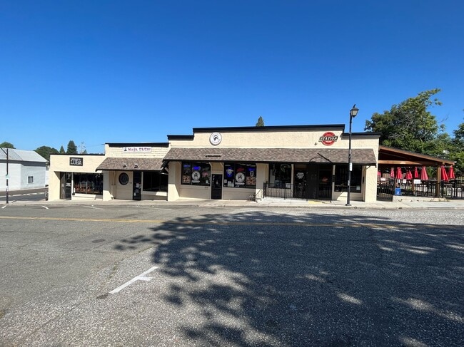
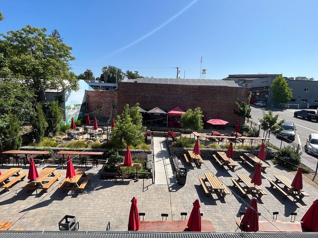
Property Record
770 Lincoln Way, Auburn, CA 95603

NEARBY LISTINGS FOR SALE OR LEASE
Property Detail
770 Lincoln Way
Sacramento--Roseville--Arden-Arcade, CA
Auburn, City Of (Original Town)
002-082-020
LOT 1 FREEMAN TRACT
Storemultistory
Placer
X
California
06061C0764H
1
2024
0.52 AC
2025
Auburn/Loomis
020300
Sacramento
8,856 SF
DEMOGRAPHICS near 770 Lincoln Way
1 Mile
3 Mile
5 Mile
2024 Total Population
7,125
24,338
40,711
2029 Population
7,659
26,118
43,487
Pop Growth 2024-2029
+ 7.49%
+ 7.31%
+ 6.82%
Average Age
45
46
46
2024 Total Households
3,306
10,426
16,813
HH Growth 2024-2029
+ 7.62%
+ 7.44%
+ 6.95%
Median Household Inc
$61,269
$83,268
$85,795
Avg Household Size
2.10
2.30
2.30
2024 Avg HH Vehicles
2.00
2.00
2.00
Median Home Value
$593,750
$601,687
$609,593
Median Year Built
1976
1978
1979
Nearby Places
Map Layers
Map Styles
 Street
 Aerial
- Restaurants
- Banks
- Shops
- Fitness
- Groceries
PUBLIC TRANSPORTATION
COMMUTER RAIL
Auburn-Conheim (Capitol Corridor - Capitol Corridor Joint Powers Authority)
DRIVE
WALK
Distance
Auburn-Conheim (Capitol Corridor - Capitol Corridor Joint Powers Authority)
3 min
19 min
1.0 mi
Auburn Amtrak (Capitol Corridor - Amtrak)
DRIVE
WALK
Distance
Auburn Amtrak (Capitol Corridor - Amtrak)
3 min
20 min
1.0 mi
Freight Ports
Port of Stockton
DRIVE
WALK
Distance
Port of Stockton
94 min
80.7 mi
SALE & LEASE HISTORY
LISTING DATE
SALE/LEASE

Jun 27, 2017
For Lease
Jun 20, 2023
For Sale
Aug 23, 2023
For Sale
Nearby Properties
Address
Land Use
TOTAL SIZE
Lot Size
Zoning
Address
Land Use
TOTAL SIZE
Lot Size
Zoning
84,588 SF
7.30 AC
CPDDC
Address
Land Use
TOTAL SIZE
Lot Size
Zoning
43,785 SF
3.80 AC
Address
Land Use
TOTAL SIZE
Lot Size
Zoning
81,175 SF
2.70 AC
Address
Land Use
TOTAL SIZE
Lot Size
Zoning
72,664 SF
9.80 AC
CPDDC
Address
Land Use
TOTAL SIZE
Lot Size
Zoning
124,714 SF
7.90 AC
Address
Land Use
TOTAL SIZE
Lot Size
Zoning
97,458 SF
7.90 AC
HSDC
Address
Land Use
TOTAL SIZE
Lot Size
Zoning
55,721 SF
3.10 AC
Address
Land Use
TOTAL SIZE
Lot Size
Zoning
52,100 SF
2.30 AC
Address
Land Use
TOTAL SIZE
Lot Size
Zoning
101,170 SF
4.95 AC
Address
Land Use
TOTAL SIZE
Lot Size
Zoning
53,860 SF
3.70 AC
RMDL15DC
Address
Land Use
TOTAL SIZE
Lot Size
Zoning
25,316 SF
2 AC
HSDC
Address
Land Use
TOTAL SIZE
Lot Size
Zoning
18.50 AC
CPDDC
Address
Land Use
TOTAL SIZE
Lot Size
Zoning
49,023 SF
0.89 AC
Address
Land Use
TOTAL SIZE
Lot Size
Zoning
37,259 SF
5.80 AC
Address
Land Use
TOTAL SIZE
Lot Size
Zoning
49,000 SF
2 AC
Address
Land Use
TOTAL SIZE
Lot Size
Zoning
38,276 SF
5.60 AC
Address
Land Use
TOTAL SIZE
Lot Size
Zoning
50,450 SF
2.60 AC
Address
Land Use
TOTAL SIZE
Lot Size
Zoning
13,659 SF
2.10 AC
RMDL6
Address
Land Use
TOTAL SIZE
Lot Size
Zoning
32,210 SF
5.50 AC
C2DC
Address
Land Use
TOTAL SIZE
Lot Size
Zoning
65,550 SF
5.70 AC
Address
Land Use
TOTAL SIZE
Lot Size
Zoning
35,418 SF
2.70 AC
Address
Land Use
TOTAL SIZE
Lot Size
Zoning
44,800 SF
4.10 AC
Address
Land Use
TOTAL SIZE
Lot Size
Zoning
38,448 SF
2.40 AC
Address
Land Use
TOTAL SIZE
Lot Size
Zoning
45,540 SF
1.90 AC
CPDDC
Address
Land Use
TOTAL SIZE
Lot Size
Zoning
26,064 SF
1.60 AC
Address
Land Use
TOTAL SIZE
Lot Size
Zoning
1 SF
2.10 AC
HSDC
Address
Land Use
TOTAL SIZE
Lot Size
Zoning
23,426 SF
2.40 AC
Address
Land Use
TOTAL SIZE
Lot Size
Zoning
54,476 SF
7.82 AC
Address
Land Use
TOTAL SIZE
Lot Size
Zoning
30,419 SF
3 AC
The World's #1 Commercial Real Estate Marketplace
Connect with us
© 2026 CoStar Group
The information above has been obtained from sources believed reliable. While we do not doubt its accuracy we have not verified it and make no guarantee, warranty or representation about it. It is your responsibility to independently confirm its accuracy and completeness. Any projections, opinions, assumptions, or estimates used are for example only and do not represent the current or future performance of the property. The value of this transaction to you depends on tax and other factors which should be evaluated by your tax, financial, and legal advisors. You and your advisors should conduct a careful, independent investigation of the property to determine to your satisfaction the suitability of the property for your needs.