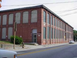
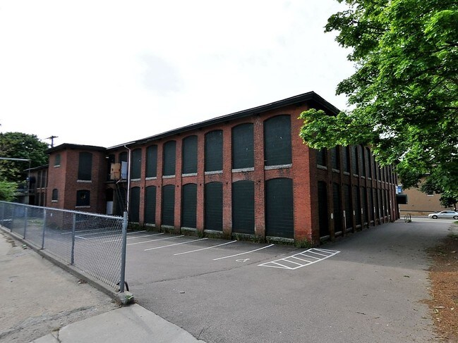
Property Record
770 Main St, West Warwick, RI 02893

Property Detail
770 Main St
Commercialbuilding
Kent
CI
Rhode Island
B and X Area of moderate flood hazard, usually the area between the limits of the 100-year and 500-year floods.
0.89 AC
2025
West Warwick
2025
Providence
020400
Providence-Warwick, RI-MA
47,424 SF
WWAR-000002-000478-000000
NEARBY LISTINGS FOR SALE OR LEASE
DEMOGRAPHICS near 770 Main St
1 mile
3 mile
5 mile
2025 Total Population
10,444
54,791
124,341
2030 Population
10,586
55,700
126,972
Pop Growth 2025-2030
+ 1.36%
+ 1.66%
+ 2.12%
Average Age
41
42
43
2025 Total Households
4,376
22,980
51,884
HH Growth 2025-2030
+ 1.33%
+ 1.60%
+ 2.10%
Median Household Inc
$98,228
$88,722
$93,899
Avg Household Size
2.30
2.30
2.30
2025 Avg HH Vehicles
2.00
2.00
2.00
Median Home Value
$318,444
$352,731
$381,985
Median Year Built
1949
1964
1970
Nearby Places
Map Layers
Map Styles
 Street
 Aerial
Layers
 Traffic
 Biking
Places
Listings with unknown addresses are not visible on the map
- Restaurants
- Banks
- Shops
- Fitness
- Groceries
PUBLIC TRANSPORTATION
COMMUTER RAIL
Drive
Walk
Distance
13 min
6.6 mi
AIRPORT
Rhode Island Tf Green International
Drive
Walk
Distance
Rhode Island Tf Green International
18 min
9.0 mi
Freight Ports
Port of Davisville, RI
Drive
Walk
Distance
Port of Davisville, RI
27 min
14.2 mi
SALE & LEASE HISTORY
LISTING DATE
SALE/LEASE

Sep 24, 2016
For Sale
Sep 17, 2018
For Sale
Nov 01, 2017
For Sale
May 17, 2017
For Sale
Jul 19, 2018
For Sale
Aug 03, 2020
For Sale
Nearby Properties
Address
Land Use
TOTAL SIZE
Lot Size
Zoning
Address
Land Use
TOTAL SIZE
Lot Size
Zoning
6,720 SF
0.01 AC
GB
Address
Land Use
TOTAL SIZE
Lot Size
Zoning
83,747 SF
20.32 AC
GB
Address
Land Use
TOTAL SIZE
Lot Size
Zoning
171,576 SF
0.70 AC
O
Address
Land Use
TOTAL SIZE
Lot Size
Zoning
11.48 AC
R-10
Address
Land Use
TOTAL SIZE
Lot Size
Zoning
411,032 SF
31.40 AC
GB
Address
Land Use
TOTAL SIZE
Lot Size
Zoning
25 AC
CI
Address
Land Use
TOTAL SIZE
Lot Size
Zoning
11.63 AC
R-10
Address
Land Use
TOTAL SIZE
Lot Size
Zoning
116,940 SF
23.17 AC
Address
Land Use
TOTAL SIZE
Lot Size
Zoning
240,425 SF
104.76 AC
R-10
Address
Land Use
TOTAL SIZE
Lot Size
Zoning
225,075 SF
4.29 AC
6000
Address
Land Use
TOTAL SIZE
Lot Size
Zoning
118,798 SF
25.61 AC
GB
Address
Land Use
TOTAL SIZE
Lot Size
Zoning
169,035 SF
4 AC
6000
Address
Land Use
TOTAL SIZE
Lot Size
Zoning
131,136 SF
32.78 AC
GB
Address
Land Use
TOTAL SIZE
Lot Size
Zoning
117,756 SF
8.67 AC
C4
Address
Land Use
TOTAL SIZE
Lot Size
Zoning
123,035 SF
99 AC
R-20
Address
Land Use
TOTAL SIZE
Lot Size
Zoning
137,992 SF
1.30 AC
B
Address
Land Use
TOTAL SIZE
Lot Size
Zoning
164,592 SF
3.02 AC
O
Address
Land Use
TOTAL SIZE
Lot Size
Zoning
6.36 AC
CI
Address
Land Use
TOTAL SIZE
Lot Size
Zoning
186,260 SF
12.99 AC
GB
Address
Land Use
TOTAL SIZE
Lot Size
Zoning
88,293 SF
29.51 AC
GB
Address
Land Use
TOTAL SIZE
Lot Size
Zoning
11.80 AC
R-10
Address
Land Use
TOTAL SIZE
Lot Size
Zoning
128,189 SF
8.98 AC
GB
Address
Land Use
TOTAL SIZE
Lot Size
Zoning
3,503 SF
65.88 AC
A15
Address
Land Use
TOTAL SIZE
Lot Size
Zoning
136,294 SF
24.68 AC
GB
Address
Land Use
TOTAL SIZE
Lot Size
Zoning
120,625 SF
57.93 AC
GB
Address
Land Use
TOTAL SIZE
Lot Size
Zoning
66,780 SF
6.88 AC
GB
Address
Land Use
TOTAL SIZE
Lot Size
Zoning
49,816 SF
14.61 AC
A7
Address
Land Use
TOTAL SIZE
Lot Size
Zoning
2.31 AC
R-6
Address
Land Use
TOTAL SIZE
Lot Size
Zoning
103,936 SF
2.13 AC
R-6
Address
Land Use
TOTAL SIZE
Lot Size
Zoning
68,287 SF
7.09 AC
GB
The World's #1 Commercial Real Estate Marketplace
Connect with us
© 2026 CoStar Group
The information above has been obtained from sources believed reliable. While we do not doubt its accuracy we have not verified it and make no guarantee, warranty or representation about it. It is your responsibility to independently confirm its accuracy and completeness. Any projections, opinions, assumptions, or estimates used are for example only and do not represent the current or future performance of the property. The value of this transaction to you depends on tax and other factors which should be evaluated by your tax, financial, and legal advisors. You and your advisors should conduct a careful, independent investigation of the property to determine to your satisfaction the suitability of the property for your needs.