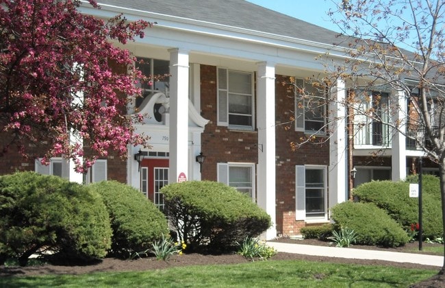
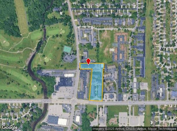
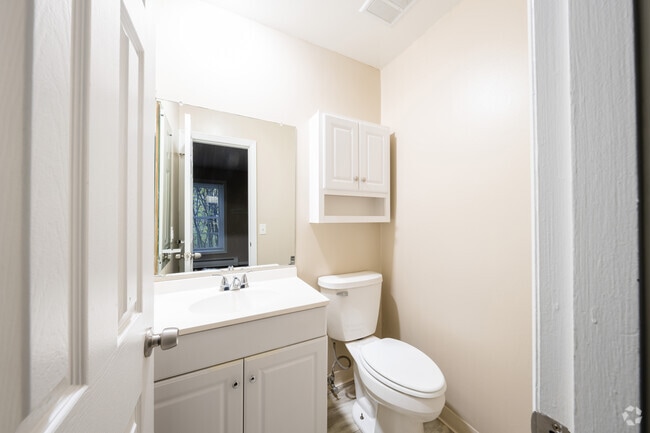
Property Record
770 Maple Rd, Buffalo, NY 14221

NEARBY LISTINGS FOR SALE OR LEASE
Property Detail
770 Maple Rd
Buffalo-Cheektowaga-Niagara Falls, NY
Holland Land Company S Survey
142289-055-160-0002-022-000
61 12 7
Apartment
Erie
X
New York
36029C0207H
22.000
2025
4.50 AC
2024
East Amherst/Williamsville
009011
Buffalo/Niagara Falls
17,136 SF
DEMOGRAPHICS near 770 Maple Rd
1 Mile
3 Mile
5 Mile
2024 Total Population
10,208
93,707
242,691
2029 Population
10,281
93,966
241,637
Pop Growth 2024-2029
+ 0.72%
+ 0.28%
(0.43%)
Average Age
43
42
41
2024 Total Households
4,082
36,510
99,656
HH Growth 2024-2029
+ 0.81%
+ 0.39%
(0.45%)
Median Household Inc
$99,410
$85,492
$71,680
Avg Household Size
2.40
2.30
2.30
2024 Avg HH Vehicles
2.00
2.00
2.00
Median Home Value
$266,752
$267,992
$216,811
Median Year Built
1967
1971
1962
Nearby Places
- Restaurants
- Banks
- Shops
- Fitness
- Groceries
PUBLIC TRANSPORTATION
COMMUTER RAIL
Buffalo Depew Station (Empire Service - Amtrak, Lake Shore Limited - Amtrak, Maple Leaf - Amtrak)
DRIVE
WALK
Distance
Buffalo Depew Station (Empire Service - Amtrak, Lake Shore Limited - Amtrak, Maple Leaf - Amtrak)
15 min
7.1 mi
Buffalo (Depew) (Toronto - New York - VIA Rail)
DRIVE
WALK
Distance
Buffalo (Depew) (Toronto - New York - VIA Rail)
16 min
7.1 mi
AIRPORT
Buffalo Niagara International
DRIVE
WALK
Distance
Buffalo Niagara International
11 min
5.0 mi
Niagara Falls International
DRIVE
WALK
Distance
Niagara Falls International
26 min
13.8 mi
Freight Ports
Albany, NY Port
DRIVE
WALK
Distance
Albany, NY Port
335 min
284.9 mi
Nearby Properties
Address
Land Use
TOTAL SIZE
Lot Size
Zoning
Address
Land Use
TOTAL SIZE
Lot Size
Zoning
2,592,064 SF
1,057.90 AC
Address
Land Use
TOTAL SIZE
Lot Size
Zoning
109,328 SF
12.77 AC
GB
Address
Land Use
TOTAL SIZE
Lot Size
Zoning
308,191 SF
19.74 AC
CF
Address
Land Use
TOTAL SIZE
Lot Size
Zoning
409,925 SF
36.41 AC
CTR-5
Address
Land Use
TOTAL SIZE
Lot Size
Zoning
132,940 SF
41.50 AC
CF
Address
Land Use
TOTAL SIZE
Lot Size
Zoning
Address
Land Use
TOTAL SIZE
Lot Size
Zoning
283,706 SF
68.90 AC
Address
Land Use
TOTAL SIZE
Lot Size
Zoning
177,000 SF
14.91 AC
CF
Address
Land Use
TOTAL SIZE
Lot Size
Zoning
41,104 SF
27.52 AC
Address
Land Use
TOTAL SIZE
Lot Size
Zoning
322,151 SF
44.99 AC
Address
Land Use
TOTAL SIZE
Lot Size
Zoning
2,592 SF
22.75 AC
NCD
Address
Land Use
TOTAL SIZE
Lot Size
Zoning
16,065 SF
19.75 AC
Address
Land Use
TOTAL SIZE
Lot Size
Zoning
8,565 SF
22.65 AC
Address
Land Use
TOTAL SIZE
Lot Size
Zoning
24,600 SF
19.20 AC
00000
Address
Land Use
TOTAL SIZE
Lot Size
Zoning
12,262 SF
29 AC
MFR-5
Address
Land Use
TOTAL SIZE
Lot Size
Zoning
172,400 SF
116.50 AC
Address
Land Use
TOTAL SIZE
Lot Size
Zoning
260,326 SF
22.70 AC
Address
Land Use
TOTAL SIZE
Lot Size
Zoning
213,943 SF
5.50 AC
Address
Land Use
TOTAL SIZE
Lot Size
Zoning
181,897 SF
15.30 AC
CTR-2.5
Address
Land Use
TOTAL SIZE
Lot Size
Zoning
8,842 SF
29.30 AC
Address
Land Use
TOTAL SIZE
Lot Size
Zoning
Address
Land Use
TOTAL SIZE
Lot Size
Zoning
71,053 SF
2.52 AC
OB
Address
Land Use
TOTAL SIZE
Lot Size
Zoning
197,430 SF
8.20 AC
Address
Land Use
TOTAL SIZE
Lot Size
Zoning
Address
Land Use
TOTAL SIZE
Lot Size
Zoning
3,630 SF
10.50 AC
Address
Land Use
TOTAL SIZE
Lot Size
Zoning
7,744 SF
17.82 AC
Address
Land Use
TOTAL SIZE
Lot Size
Zoning
403,248 SF
53.50 AC
Address
Land Use
TOTAL SIZE
Lot Size
Zoning
54,109 SF
6.19 AC
OB
Address
Land Use
TOTAL SIZE
Lot Size
Zoning
83,256 SF
8.01 AC
NCD
Address
Land Use
TOTAL SIZE
Lot Size
Zoning
The World's #1 Commercial Real Estate Marketplace
Connect with us
© 2025 CoStar Group
The information above has been obtained from sources believed reliable. While we do not doubt its accuracy we have not verified it and make no guarantee, warranty or representation about it. It is your responsibility to independently confirm its accuracy and completeness. Any projections, opinions, assumptions, or estimates used are for example only and do not represent the current or future performance of the property. The value of this transaction to you depends on tax and other factors which should be evaluated by your tax, financial, and legal advisors. You and your advisors should conduct a careful, independent investigation of the property to determine to your satisfaction the suitability of the property for your needs.