Property Record
770 N Plano St, Porterville, CA 93257

NEARBY LISTINGS FOR SALE OR LEASE
Property Detail
770 N Plano St
Visalia-Porterville, CA
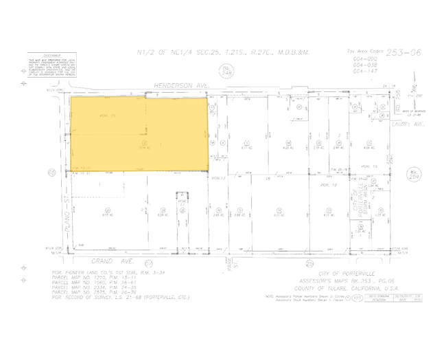
Pioneer Land Companys First Subdivision
253-060-032-000
NORTH2 LOT20
Lightindustrial
Tulare
AH
California
06107C1634E
1
2024
15.54 AC
2025
E Outlying Tulare County
003902
Visalia/Porterville
79,970 SF
DEMOGRAPHICS near 770 N Plano St
1 Mile
3 Mile
5 Mile
2024 Total Population
8,861
58,934
76,816
2029 Population
8,996
59,772
77,976
Pop Growth 2024-2029
+ 1.52%
+ 1.42%
+ 1.51%
Average Age
34
34
35
2024 Total Households
2,605
16,693
22,051
HH Growth 2024-2029
+ 1.50%
+ 1.40%
+ 1.48%
Median Household Inc
$49,964
$57,444
$62,904
Avg Household Size
3.20
3.40
3.40
2024 Avg HH Vehicles
2.00
2.00
2.00
Median Home Value
$260,332
$274,233
$297,682
Median Year Built
1974
1977
1981
Nearby Places
Map Layers
Map Styles
 Street
 Aerial
- Restaurants
- Banks
- Shops
- Fitness
- Groceries
Nearby Properties
Address
Land Use
TOTAL SIZE
Lot Size
Zoning
Address
Land Use
TOTAL SIZE
Lot Size
Zoning
727,643 SF
43.05 AC
M-1
Address
Land Use
TOTAL SIZE
Lot Size
Zoning
Address
Land Use
TOTAL SIZE
Lot Size
Zoning
Address
Land Use
TOTAL SIZE
Lot Size
Zoning
379,008 SF
36.46 AC
M-1
Address
Land Use
TOTAL SIZE
Lot Size
Zoning
139,487 SF
11.54 AC
CR
Address
Land Use
TOTAL SIZE
Lot Size
Zoning
132,942 SF
10.11 AC
C-2 D
Address
Land Use
TOTAL SIZE
Lot Size
Zoning
73.61 AC
Address
Land Use
TOTAL SIZE
Lot Size
Zoning
Address
Land Use
TOTAL SIZE
Lot Size
Zoning
Address
Land Use
TOTAL SIZE
Lot Size
Zoning
2.52 AC
C-2
Address
Land Use
TOTAL SIZE
Lot Size
Zoning
71,583 SF
6.41 AC
Address
Land Use
TOTAL SIZE
Lot Size
Zoning
82,280 SF
6.41 AC
Address
Land Use
TOTAL SIZE
Lot Size
Zoning
52,620 SF
3.82 AC
Address
Land Use
TOTAL SIZE
Lot Size
Zoning
79,504 SF
4.50 AC
Address
Land Use
TOTAL SIZE
Lot Size
Zoning
Address
Land Use
TOTAL SIZE
Lot Size
Zoning
95,450 SF
11.61 AC
CR
Address
Land Use
TOTAL SIZE
Lot Size
Zoning
125,074 SF
5.96 AC
Address
Land Use
TOTAL SIZE
Lot Size
Zoning
48,032 SF
5 AC
P-D(C)
Address
Land Use
TOTAL SIZE
Lot Size
Zoning
54,129 SF
3.44 AC
C-3
Address
Land Use
TOTAL SIZE
Lot Size
Zoning
32,968 SF
4.96 AC
Address
Land Use
TOTAL SIZE
Lot Size
Zoning
2.07 AC
Address
Land Use
TOTAL SIZE
Lot Size
Zoning
30,036 SF
2.51 AC
PO
Address
Land Use
TOTAL SIZE
Lot Size
Zoning
51,360 SF
3.96 AC
R3-D
Address
Land Use
TOTAL SIZE
Lot Size
Zoning
64,271 SF
1.90 AC
R4D
Address
Land Use
TOTAL SIZE
Lot Size
Zoning
32,167 SF
3.26 AC
Address
Land Use
TOTAL SIZE
Lot Size
Zoning
16,464 SF
13.44 AC
Address
Land Use
TOTAL SIZE
Lot Size
Zoning
12,690 SF
0.77 AC
The World's #1 Commercial Real Estate Marketplace
Connect with us
© 2025 CoStar Group
The information above has been obtained from sources believed reliable. While we do not doubt its accuracy we have not verified it and make no guarantee, warranty or representation about it. It is your responsibility to independently confirm its accuracy and completeness. Any projections, opinions, assumptions, or estimates used are for example only and do not represent the current or future performance of the property. The value of this transaction to you depends on tax and other factors which should be evaluated by your tax, financial, and legal advisors. You and your advisors should conduct a careful, independent investigation of the property to determine to your satisfaction the suitability of the property for your needs.