No Photo
Property Record
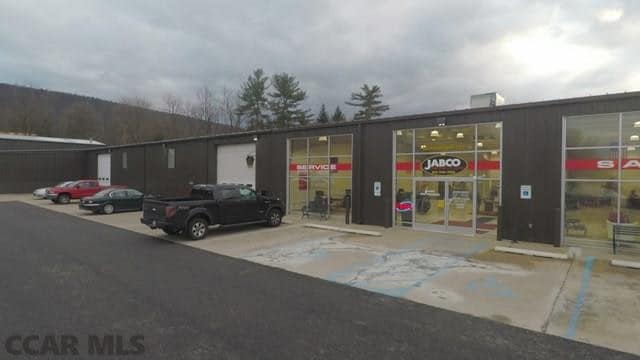
770 W College Ave, Pleasant Gap, PA 16823


NEARBY LISTINGS FOR SALE OR LEASE
Property Detail
770 W College Ave
12-005-034A-0000
Richard D Thomas Subdivision
Commercialnec
Centre
X
Pennsylvania
42027C0632F
5 AC
2025
Pennsylvania Central Area
2025
Other Market Areas
011201
State College, PA
DEMOGRAPHICS near 770 W College Ave
1 Mile
3 Mile
5 Mile
2024 Total Population
728
10,625
30,636
2029 Population
729
10,631
30,539
Pop Growth 2024-2029
+ 0.14%
+ 0.06%
(0.32%)
Average Age
44
44
43
2024 Total Households
314
2,686
10,961
HH Growth 2024-2029
+ 0.32%
+ 0.15%
(0.36%)
Median Household Inc
$82,916
$77,823
$79,118
Avg Household Size
2.20
2.20
2.20
2024 Avg HH Vehicles
2.00
2.00
2.00
Median Home Value
$170,869
$225,335
$263,775
Median Year Built
1957
1983
1979
Nearby Places
Map Layers
Map Styles
 Street
 Aerial
- Restaurants
- Banks
- Shops
- Fitness
- Groceries
PUBLIC TRANSPORTATION
AIRPORT
State College Regional
DRIVE
WALK
Distance
State College Regional
20 min
8.6 mi
SALE & LEASE HISTORY
LISTING DATE
SALE/LEASE

Feb 15, 2018
For Sale
Feb 09, 2018
For Sale
Nearby Properties
Address
Land Use
TOTAL SIZE
Lot Size
Zoning
Address
Land Use
TOTAL SIZE
Lot Size
Zoning
Address
Land Use
TOTAL SIZE
Lot Size
Zoning
3,976.61 AC
Address
Land Use
TOTAL SIZE
Lot Size
Zoning
51.86 AC
Address
Land Use
TOTAL SIZE
Lot Size
Zoning
29.15 AC
Address
Land Use
TOTAL SIZE
Lot Size
Zoning
15.41 AC
Address
Land Use
TOTAL SIZE
Lot Size
Zoning
23.59 AC
Address
Land Use
TOTAL SIZE
Lot Size
Zoning
5.49 AC
Address
Land Use
TOTAL SIZE
Lot Size
Zoning
Address
Land Use
TOTAL SIZE
Lot Size
Zoning
Address
Land Use
TOTAL SIZE
Lot Size
Zoning
32.57 AC
Address
Land Use
TOTAL SIZE
Lot Size
Zoning
Address
Land Use
TOTAL SIZE
Lot Size
Zoning
38.74 AC
Address
Land Use
TOTAL SIZE
Lot Size
Zoning
Address
Land Use
TOTAL SIZE
Lot Size
Zoning
12.57 AC
Address
Land Use
TOTAL SIZE
Lot Size
Zoning
32.57 AC
Address
Land Use
TOTAL SIZE
Lot Size
Zoning
217.96 AC
Address
Land Use
TOTAL SIZE
Lot Size
Zoning
2.50 AC
Address
Land Use
TOTAL SIZE
Lot Size
Zoning
Address
Land Use
TOTAL SIZE
Lot Size
Zoning
Address
Land Use
TOTAL SIZE
Lot Size
Zoning
9.23 AC
Address
Land Use
TOTAL SIZE
Lot Size
Zoning
Address
Land Use
TOTAL SIZE
Lot Size
Zoning
21.08 AC
Address
Land Use
TOTAL SIZE
Lot Size
Zoning
55.59 AC
Address
Land Use
TOTAL SIZE
Lot Size
Zoning
Address
Land Use
TOTAL SIZE
Lot Size
Zoning
Address
Land Use
TOTAL SIZE
Lot Size
Zoning
19.93 AC
Address
Land Use
TOTAL SIZE
Lot Size
Zoning
698.36 AC
Address
Land Use
TOTAL SIZE
Lot Size
Zoning
18.54 AC
Address
Land Use
TOTAL SIZE
Lot Size
Zoning
The World's #1 Commercial Real Estate Marketplace
Connect with us
© 2026 CoStar Group
The information above has been obtained from sources believed reliable. While we do not doubt its accuracy we have not verified it and make no guarantee, warranty or representation about it. It is your responsibility to independently confirm its accuracy and completeness. Any projections, opinions, assumptions, or estimates used are for example only and do not represent the current or future performance of the property. The value of this transaction to you depends on tax and other factors which should be evaluated by your tax, financial, and legal advisors. You and your advisors should conduct a careful, independent investigation of the property to determine to your satisfaction the suitability of the property for your needs.