Property Record
1940 Northwestern Dr, El Paso, TX 79912
Current Lease Availabilities
NEARBY LISTINGS FOR SALE OR LEASE
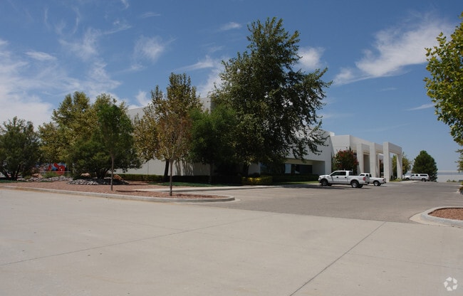
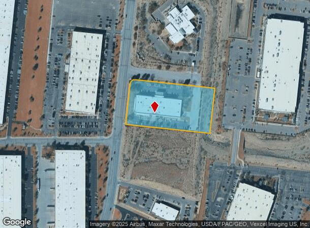
Property Detail
1940 Northwestern Dr
El Paso, TX
Westport #1
W178-999-0040-0125
4 WESTPORT #3 N 300 FT OF 1 (164808.18 SQ FT)
Commercialnec
El Paso
2024
Texas
2025
3.78 AC
010226
West
36,160 SF
El Paso
DEMOGRAPHICS near 1940 Northwestern Dr
1 Mile
3 Mile
5 Mile
2024 Total Population
4,762
44,676
110,284
2029 Population
4,944
45,338
111,872
Pop Growth 2024-2029
+ 3.82%
+ 1.48%
+ 1.44%
Average Age
33
36
38
2024 Total Households
1,547
14,694
37,515
HH Growth 2024-2029
+ 3.75%
+ 1.44%
+ 1.41%
Median Household Inc
$79,014
$75,427
$75,492
Avg Household Size
3.10
3.00
2.90
2024 Avg HH Vehicles
2.00
2.00
2.00
Median Home Value
$225,748
$204,469
$223,826
Median Year Built
2011
2001
1994
Nearby Places
Map Layers
Map Styles
 Street
 Aerial
- Restaurants
- Banks
- Shops
- Fitness
- Groceries
PUBLIC TRANSPORTATION
AIRPORT
El Paso International
DRIVE
WALK
Distance
El Paso International
39 min
22.5 mi
Freight Ports
Port of Corpus Christi
DRIVE
WALK
Distance
Port of Corpus Christi
700 min
709.3 mi
Nearby Properties
Address
Land Use
TOTAL SIZE
Lot Size
Zoning
Address
Land Use
TOTAL SIZE
Lot Size
Zoning
279,966 SF
44.49 AC
C4C
Address
Land Use
TOTAL SIZE
Lot Size
Zoning
409,742 SF
37.76 AC
C4
Address
Land Use
TOTAL SIZE
Lot Size
Zoning
127,552 SF
14.24 AC
C4
Address
Land Use
TOTAL SIZE
Lot Size
Zoning
545,506 SF
50.94 AC
M1
Address
Land Use
TOTAL SIZE
Lot Size
Zoning
236,134 SF
14.49 AC
C1
Address
Land Use
TOTAL SIZE
Lot Size
Zoning
234,339 SF
10.03 AC
C3C
Address
Land Use
TOTAL SIZE
Lot Size
Zoning
149,913 SF
66.49 AC
R3S
Address
Land Use
TOTAL SIZE
Lot Size
Zoning
402,206 SF
21.82 AC
C4C
Address
Land Use
TOTAL SIZE
Lot Size
Zoning
199,384 SF
17.91 AC
C4
Address
Land Use
TOTAL SIZE
Lot Size
Zoning
112,960 SF
Address
Land Use
TOTAL SIZE
Lot Size
Zoning
220,159 SF
29.02 AC
C4
Address
Land Use
TOTAL SIZE
Lot Size
Zoning
79,722 SF
11 AC
C3
Address
Land Use
TOTAL SIZE
Lot Size
Zoning
103,525 SF
7 AC
M1
Address
Land Use
TOTAL SIZE
Lot Size
Zoning
206,600 SF
10.74 AC
AO
Address
Land Use
TOTAL SIZE
Lot Size
Zoning
115,155 SF
4.63 AC
C2C
Address
Land Use
TOTAL SIZE
Lot Size
Zoning
415,500 SF
33.44 AC
M1
Address
Land Use
TOTAL SIZE
Lot Size
Zoning
46,534 SF
9.81 AC
C4C
Address
Land Use
TOTAL SIZE
Lot Size
Zoning
127,595 SF
9.64 AC
C4S
Address
Land Use
TOTAL SIZE
Lot Size
Zoning
149,514 SF
18.14 AC
M1
Address
Land Use
TOTAL SIZE
Lot Size
Zoning
143,828 SF
15.77 AC
M1
Address
Land Use
TOTAL SIZE
Lot Size
Zoning
136,776 SF
16.26 AC
C4S
Address
Land Use
TOTAL SIZE
Lot Size
Zoning
290,880 SF
9.79 AC
Address
Land Use
TOTAL SIZE
Lot Size
Zoning
21,621 SF
167.69 AC
R3
Address
Land Use
TOTAL SIZE
Lot Size
Zoning
271,352 SF
29.85 AC
M1S
Address
Land Use
TOTAL SIZE
Lot Size
Zoning
119,090 SF
11.66 AC
C4
Address
Land Use
TOTAL SIZE
Lot Size
Zoning
239,984 SF
13.50 AC
M1
Address
Land Use
TOTAL SIZE
Lot Size
Zoning
161,000 SF
10.37 AC
C4
Address
Land Use
TOTAL SIZE
Lot Size
Zoning
44,694 SF
4.86 AC
C3
Address
Land Use
TOTAL SIZE
Lot Size
Zoning
64,722 SF
3.14 AC
C3
Address
Land Use
TOTAL SIZE
Lot Size
Zoning
114,786 SF
10.67 AC
C4
The World's #1 Commercial Real Estate Marketplace
Connect with us
© 2025 CoStar Group
The information above has been obtained from sources believed reliable. While we do not doubt its accuracy we have not verified it and make no guarantee, warranty or representation about it. It is your responsibility to independently confirm its accuracy and completeness. Any projections, opinions, assumptions, or estimates used are for example only and do not represent the current or future performance of the property. The value of this transaction to you depends on tax and other factors which should be evaluated by your tax, financial, and legal advisors. You and your advisors should conduct a careful, independent investigation of the property to determine to your satisfaction the suitability of the property for your needs.