Property Record
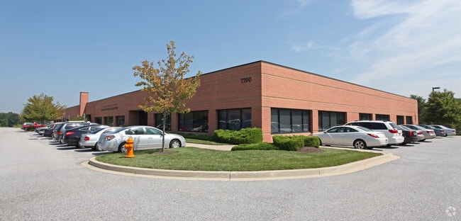
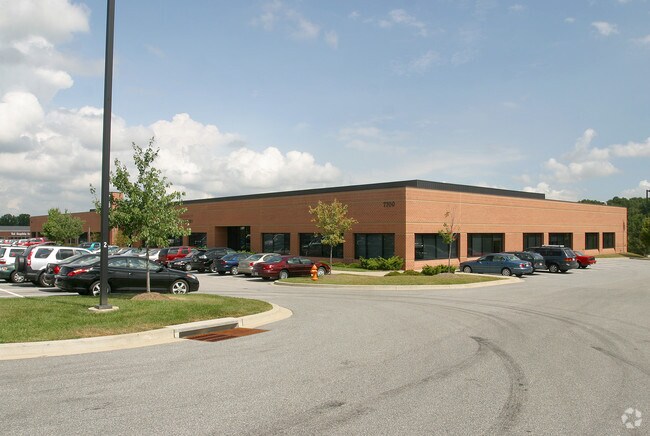
7700 Montpelier Rd, Laurel, MD 20723


Property Detail
7700 Montpelier Rd
05-433746
PAR E 6 4.874 A 7700-10 MONTPELIER RD MONTPELIER RESEARCH PARK
Officebuilding
HOWARD
PEC
Maryland
B and X Area of moderate flood hazard, usually the area between the limits of the 100-year and 500-year floods.
e 6
2025
4.87 AC
2025
Columbia South
606907
Baltimore
43,610 SF
Baltimore-Columbia-Towson, MD
NEARBY LISTINGS FOR SALE OR LEASE
DEMOGRAPHICS near 7700 Montpelier Rd
1 mile
3 mile
5 mile
2025 Total Population
4,757
52,358
175,362
2030 Population
4,810
53,077
177,650
Pop Growth 2025-2030
+ 1.11%
+ 1.37%
+ 1.30%
Average Age
40
41
40
2025 Total Households
1,625
18,413
64,954
HH Growth 2025-2030
+ 1.23%
+ 1.44%
+ 1.33%
Median Household Inc
$185,433
$174,250
$125,410
Avg Household Size
2.90
2.80
2.70
2025 Avg HH Vehicles
2.00
2.00
2.00
Median Home Value
$733,854
$690,093
$527,318
Median Year Built
1994
1987
1984
Nearby Places
Map Layers
Map Styles
 Street
 Aerial
Layers
 Traffic
 Biking
Places
Listings with unknown addresses are not visible on the map
- Restaurants
- Banks
- Shops
- Fitness
- Groceries
PUBLIC TRANSPORTATION
COMMUTER RAIL
Laurel Marc Sb (CAMDEN - WASHINGTON - Maryland Transit Administration)
Drive
Walk
Distance
Laurel Marc Sb (CAMDEN - WASHINGTON - Maryland Transit Administration)
14 min
6.3 mi
Laurel Racetrack Marc Sb (CAMDEN - WASHINGTON - Maryland Transit Administration)
Drive
Walk
Distance
Laurel Racetrack Marc Sb (CAMDEN - WASHINGTON - Maryland Transit Administration)
17 min
7.3 mi
AIRPORT
Baltimore/Washington International Thurgood Marshall
Drive
Walk
Distance
Baltimore/Washington International Thurgood Marshall
27 min
18.5 mi
Ronald Reagan Washington Ntl
Drive
Walk
Distance
Ronald Reagan Washington Ntl
44 min
26.3 mi
Freight Ports
Port of Baltimore
Drive
Walk
Distance
Port of Baltimore
32 min
21.4 mi
Nearby Properties
Address
Land Use
TOTAL SIZE
Lot Size
Zoning
Address
Land Use
TOTAL SIZE
Lot Size
Zoning
20,700 SF
99.42 AC
PEC
Address
Land Use
TOTAL SIZE
Lot Size
Zoning
211,144 SF
35.09 AC
PEC
Address
Land Use
TOTAL SIZE
Lot Size
Zoning
89,320 SF
101.22 AC
RRMXD
Address
Land Use
TOTAL SIZE
Lot Size
Zoning
453,692 SF
6.83 AC
R-APT
Address
Land Use
TOTAL SIZE
Lot Size
Zoning
253,974 SF
12 AC
PEC
Address
Land Use
TOTAL SIZE
Lot Size
Zoning
34,368 SF
54.80 AC
PEC
Address
Land Use
TOTAL SIZE
Lot Size
Zoning
91,666 SF
39.10 AC
RED
Address
Land Use
TOTAL SIZE
Lot Size
Zoning
191,036 SF
4.25 AC
2R0
Address
Land Use
TOTAL SIZE
Lot Size
Zoning
17,648 SF
12.24 AC
NT
Address
Land Use
TOTAL SIZE
Lot Size
Zoning
155,446 SF
10.76 AC
PEC
Address
Land Use
TOTAL SIZE
Lot Size
Zoning
242,910 SF
32.60 AC
NT
Address
Land Use
TOTAL SIZE
Lot Size
Zoning
56,148 SF
8.24 AC
PEC
Address
Land Use
TOTAL SIZE
Lot Size
Zoning
110,336 SF
41.82 AC
PECMX
Address
Land Use
TOTAL SIZE
Lot Size
Zoning
218,464 SF
35.31 AC
RSC
Address
Land Use
TOTAL SIZE
Lot Size
Zoning
21,894 SF
8.66 AC
NT
Address
Land Use
TOTAL SIZE
Lot Size
Zoning
449,129 SF
21.59 AC
NT
Address
Land Use
TOTAL SIZE
Lot Size
Zoning
142,718 SF
35 AC
R20
Address
Land Use
TOTAL SIZE
Lot Size
Zoning
24,120 SF
8.33 AC
NT
Address
Land Use
TOTAL SIZE
Lot Size
Zoning
35,709 SF
10.88 AC
NT
Address
Land Use
TOTAL SIZE
Lot Size
Zoning
157,800 SF
13.24 AC
PEC
Address
Land Use
TOTAL SIZE
Lot Size
Zoning
102,264 SF
5.73 AC
MXD 3
Address
Land Use
TOTAL SIZE
Lot Size
Zoning
139,421 SF
6 AC
MXD3
Address
Land Use
TOTAL SIZE
Lot Size
Zoning
156,702 SF
18.03 AC
NT
Address
Land Use
TOTAL SIZE
Lot Size
Zoning
18,004 SF
9.06 AC
NT
Address
Land Use
TOTAL SIZE
Lot Size
Zoning
72,152 SF
15.46 AC
NT
Address
Land Use
TOTAL SIZE
Lot Size
Zoning
96,000 SF
13.25 AC
NT
Address
Land Use
TOTAL SIZE
Lot Size
Zoning
22,124 SF
6.49 AC
NT
Address
Land Use
TOTAL SIZE
Lot Size
Zoning
133,234 SF
11.46 AC
NT
Address
Land Use
TOTAL SIZE
Lot Size
Zoning
62,128 SF
11.67 AC
NT
Address
Land Use
TOTAL SIZE
Lot Size
Zoning
89,612 SF
30.76 AC
RRDEO
The World's #1 Commercial Real Estate Marketplace
Connect with us
© 2026 CoStar Group
The information above has been obtained from sources believed reliable. While we do not doubt its accuracy we have not verified it and make no guarantee, warranty or representation about it. It is your responsibility to independently confirm its accuracy and completeness. Any projections, opinions, assumptions, or estimates used are for example only and do not represent the current or future performance of the property. The value of this transaction to you depends on tax and other factors which should be evaluated by your tax, financial, and legal advisors. You and your advisors should conduct a careful, independent investigation of the property to determine to your satisfaction the suitability of the property for your needs.