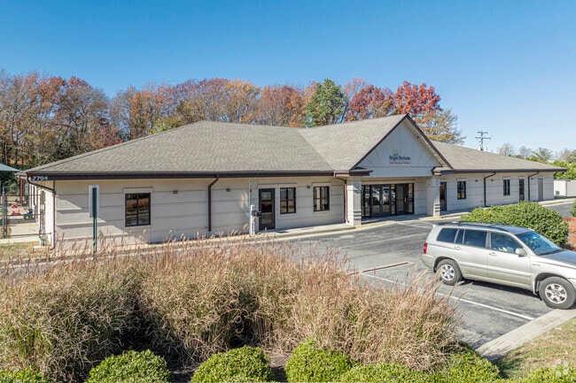
Property Record
7701 E Parham Rd, Henrico, VA 23294

Save to a Folder
{{folder.Name}}
{{folder.ListingIds.length}} Properties
{{folder.ListingIds.length}} Property
Create a New Folder
Property Detail
7701 E Parham Rd
765-754-0919
00600A0000 0026A; SHRADER ROAD AC 30.42 92 B1 44
Publicschool
HENRICO
R-6C
Virginia
B and X Area of moderate flood hazard, usually the area between the limits of the 100-year and 500-year floods.
30.42 AC
0
Broad St Corridor
2026
Richmond VA
200409
Richmond, VA
80,027 SF
NEARBY LISTINGS FOR SALE OR LEASE
DEMOGRAPHICS near 7701 E Parham Rd
1 mile
3 mile
5 mile
2025 Total Population
13,638
95,084
212,445
2030 Population
13,842
96,087
215,949
Pop Growth 2025-2030
+ 1.50%
+ 1.05%
+ 1.65%
Average Age
37
40
41
2025 Total Households
5,590
39,545
86,834
HH Growth 2025-2030
+ 1.56%
+ 1.14%
+ 1.80%
Median Household Inc
$64,097
$76,401
$92,790
Avg Household Size
2.30
2.30
2.30
2025 Avg HH Vehicles
2.00
2.00
2.00
Median Home Value
$281,281
$344,097
$402,155
Median Year Built
1980
1979
1980
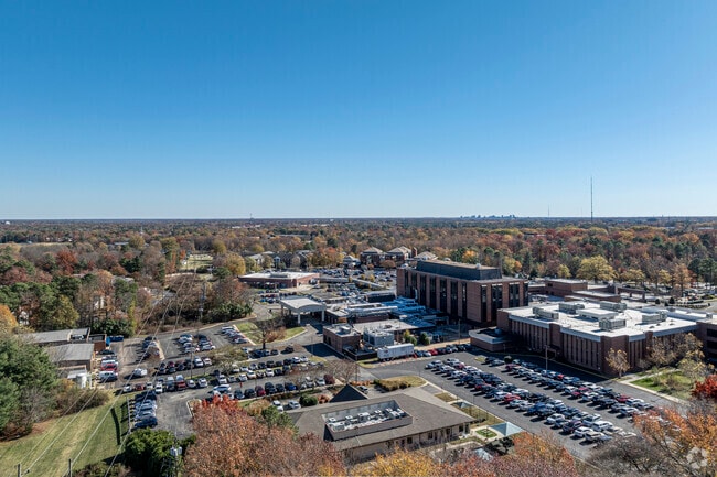
Nearby Places
Map Layers
Map Styles
 Street
 Aerial
Layers
 Traffic
 Biking
Places
Listings with unknown addresses are not visible on the map
- Restaurants
- Banks
- Shops
- Fitness
- Groceries
PUBLIC TRANSPORTATION
COMMUTER RAIL
Richmond Staples Mill Road Amtrak Station (Carolinian - Amtrak, Floridian - Amtrak, Northeast Regional - Amtrak, Palmetto - Amtrak, Silver Meteor - Amtrak)
Drive
Walk
Distance
Richmond Staples Mill Road Amtrak Station (Carolinian - Amtrak, Floridian - Amtrak, Northeast Regional - Amtrak, Palmetto - Amtrak, Silver Meteor - Amtrak)
5 min
2.7 mi
AIRPORT
Richmond International
Drive
Walk
Distance
Richmond International
29 min
18.3 mi
Freight Ports
Virginia Port Authority - Richmond
Drive
Walk
Distance
Virginia Port Authority - Richmond
27 min
16.6 mi
Nearby Properties
Address
Land Use
TOTAL SIZE
Lot Size
Zoning
Address
Land Use
TOTAL SIZE
Lot Size
Zoning
253,440 SF
48.58 AC
R-3
Address
Land Use
TOTAL SIZE
Lot Size
Zoning
585,792 SF
38.94 AC
R-5
Address
Land Use
TOTAL SIZE
Lot Size
Zoning
597,042 SF
41.03 AC
R-6C
Address
Land Use
TOTAL SIZE
Lot Size
Zoning
251,400 SF
14.42 AC
R-6C
Address
Land Use
TOTAL SIZE
Lot Size
Zoning
173,400 SF
42 AC
MIXED
Address
Land Use
TOTAL SIZE
Lot Size
Zoning
568,334 SF
26.13 AC
MIXED
Address
Land Use
TOTAL SIZE
Lot Size
Zoning
527,410 SF
40.70 AC
A-1
Address
Land Use
TOTAL SIZE
Lot Size
Zoning
184,760 SF
51.60 AC
A-1
Address
Land Use
TOTAL SIZE
Lot Size
Zoning
266,138 SF
33 AC
R-2C
Address
Land Use
TOTAL SIZE
Lot Size
Zoning
2.51 AC
UMUC
Address
Land Use
TOTAL SIZE
Lot Size
Zoning
344,965 SF
28.33 AC
MIXED
Address
Land Use
TOTAL SIZE
Lot Size
Zoning
309,500 SF
29.78 AC
MIXED
Address
Land Use
TOTAL SIZE
Lot Size
Zoning
271,060 SF
18.31 AC
R-6
Address
Land Use
TOTAL SIZE
Lot Size
Zoning
296,784 SF
23.11 AC
R-5
Address
Land Use
TOTAL SIZE
Lot Size
Zoning
1,404 SF
30.52 AC
R-5
Address
Land Use
TOTAL SIZE
Lot Size
Zoning
159,980 SF
21.38 AC
R-5C
Address
Land Use
TOTAL SIZE
Lot Size
Zoning
224,768 SF
18.08 AC
R-6
Address
Land Use
TOTAL SIZE
Lot Size
Zoning
527,344 SF
42.78 AC
R-6C
Address
Land Use
TOTAL SIZE
Lot Size
Zoning
250,146 SF
20.41 AC
R-5
Address
Land Use
TOTAL SIZE
Lot Size
Zoning
232,368 SF
26.11 AC
R-5
Address
Land Use
TOTAL SIZE
Lot Size
Zoning
182,188 SF
21.84 AC
R-5
Address
Land Use
TOTAL SIZE
Lot Size
Zoning
48,339 SF
33 AC
A-1
Address
Land Use
TOTAL SIZE
Lot Size
Zoning
500,400 SF
64 AC
R-5
Address
Land Use
TOTAL SIZE
Lot Size
Zoning
227,905 SF
58.94 AC
R-3
Address
Land Use
TOTAL SIZE
Lot Size
Zoning
257,130 SF
33.65 AC
B-3
Address
Land Use
TOTAL SIZE
Lot Size
Zoning
371,568 SF
21.19 AC
R-5
Address
Land Use
TOTAL SIZE
Lot Size
Zoning
182,264 SF
15.91 AC
R-5
Address
Land Use
TOTAL SIZE
Lot Size
Zoning
156,332 SF
15.27 AC
R-5
Address
Land Use
TOTAL SIZE
Lot Size
Zoning
272,000 SF
16.66 AC
R-5
Address
Land Use
TOTAL SIZE
Lot Size
Zoning
167,576 SF
14.29 AC
R-5
The World's #1 Commercial Real Estate Marketplace
Connect with us
© 2026 CoStar Group
The information above has been obtained from sources believed reliable. While we do not doubt its accuracy we have not verified it and make no guarantee, warranty or representation about it. It is your responsibility to independently confirm its accuracy and completeness. Any projections, opinions, assumptions, or estimates used are for example only and do not represent the current or future performance of the property. The value of this transaction to you depends on tax and other factors which should be evaluated by your tax, financial, and legal advisors. You and your advisors should conduct a careful, independent investigation of the property to determine to your satisfaction the suitability of the property for your needs.