Property Record
7701 Highway 76, Pendleton, SC 29670


Save to a Folder
{{folder.Name}}
{{folder.ListingIds.length}} Properties
{{folder.ListingIds.length}} Property
Create a New Folder
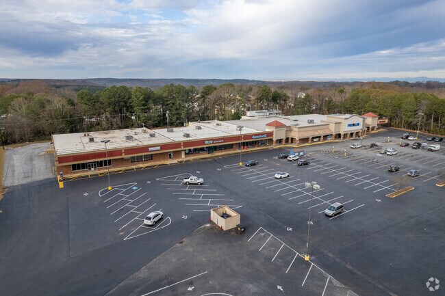
Property Detail
7701 Highway 76
041-01-01-008
CP 000/000 F766 D654 PP 077/636 HWY 76 + 28 10.68 AC
Commercialnec
ANDERSON
B and X Area of moderate flood hazard, usually the area between the limits of the 100-year and 500-year floods.
South Carolina
2025
10.68 AC
2025
Anderson Cy N of I-85
010701
Greenville/Spartanburg
69,208 SF
Greenville-Anderson-Greer, SC
NEARBY LISTINGS FOR SALE OR LEASE
DEMOGRAPHICS near 7701 Highway 76
1 mile
3 mile
5 mile
2025 Total Population
1,498
10,047
34,913
2030 Population
1,627
10,644
36,382
Pop Growth 2025-2030
+ 8.61%
+ 5.94%
+ 4.21%
Average Age
42
39
35
2025 Total Households
722
4,145
12,979
HH Growth 2025-2030
+ 8.86%
+ 6.63%
+ 4.91%
Median Household Inc
$69,210
$67,782
$59,790
Avg Household Size
2.10
2.20
2.30
2025 Avg HH Vehicles
2.00
2.00
2.00
Median Home Value
$245,673
$258,924
$289,722
Median Year Built
1994
1990
1991
Nearby Places
Map Layers
Map Styles
 Street
 Aerial
Layers
 Traffic
 Biking
Places
Listings with unknown addresses are not visible on the map
- Restaurants
- Banks
- Shops
- Fitness
- Groceries
PUBLIC TRANSPORTATION
COMMUTER RAIL
Drive
Walk
Distance
10 min
5.2 mi
AIRPORT
Greenville Spartanburg International
Drive
Walk
Distance
Greenville Spartanburg International
60 min
45.6 mi
SALE & LEASE HISTORY
LISTING DATE
SALE/LEASE

Sep 24, 2016
For Lease
Apr 27, 2022
For Lease
Nearby Properties
Address
Land Use
TOTAL SIZE
Lot Size
Zoning
Address
Land Use
TOTAL SIZE
Lot Size
Zoning
254,000 SF
94.59 AC
Address
Land Use
TOTAL SIZE
Lot Size
Zoning
6,000 SF
0.99 AC
Address
Land Use
TOTAL SIZE
Lot Size
Zoning
2,764 SF
17.46 AC
Address
Land Use
TOTAL SIZE
Lot Size
Zoning
11.42 AC
Address
Land Use
TOTAL SIZE
Lot Size
Zoning
191,000 SF
36.59 AC
RM 3 MULTI
Address
Land Use
TOTAL SIZE
Lot Size
Zoning
5,484.32 AC
Address
Land Use
TOTAL SIZE
Lot Size
Zoning
75,260 SF
2.20 AC
Address
Land Use
TOTAL SIZE
Lot Size
Zoning
6,500 SF
7.41 AC
Address
Land Use
TOTAL SIZE
Lot Size
Zoning
37,888 SF
2.93 AC
RM 2 TWO F
Address
Land Use
TOTAL SIZE
Lot Size
Zoning
1.52 AC
Address
Land Use
TOTAL SIZE
Lot Size
Zoning
32,768 SF
5.88 AC
RM 2 TWO F
Address
Land Use
TOTAL SIZE
Lot Size
Zoning
20,000 SF
14.18 AC
Address
Land Use
TOTAL SIZE
Lot Size
Zoning
14,706 SF
8.48 AC
Address
Land Use
TOTAL SIZE
Lot Size
Zoning
3.83 AC
RM 2 TWO F
Address
Land Use
TOTAL SIZE
Lot Size
Zoning
23,552 SF
2.58 AC
RM2
Address
Land Use
TOTAL SIZE
Lot Size
Zoning
4.39 AC
RM 2 TWO F
Address
Land Use
TOTAL SIZE
Lot Size
Zoning
27.50 AC
Address
Land Use
TOTAL SIZE
Lot Size
Zoning
132.18 AC
Address
Land Use
TOTAL SIZE
Lot Size
Zoning
14.58 AC
R 20 SINGL
Address
Land Use
TOTAL SIZE
Lot Size
Zoning
1,530 SF
30.62 AC
Address
Land Use
TOTAL SIZE
Lot Size
Zoning
5,839 SF
5.45 AC
Address
Land Use
TOTAL SIZE
Lot Size
Zoning
3,730 SF
1.98 AC
Address
Land Use
TOTAL SIZE
Lot Size
Zoning
Address
Land Use
TOTAL SIZE
Lot Size
Zoning
9,600 SF
1.79 AC
Address
Land Use
TOTAL SIZE
Lot Size
Zoning
10,054 SF
1.20 AC
Address
Land Use
TOTAL SIZE
Lot Size
Zoning
1.60 AC
Address
Land Use
TOTAL SIZE
Lot Size
Zoning
6,779 SF
3.82 AC
Address
Land Use
TOTAL SIZE
Lot Size
Zoning
The World's #1 Commercial Real Estate Marketplace
Connect with us
© 2026 CoStar Group
The information above has been obtained from sources believed reliable. While we do not doubt its accuracy we have not verified it and make no guarantee, warranty or representation about it. It is your responsibility to independently confirm its accuracy and completeness. Any projections, opinions, assumptions, or estimates used are for example only and do not represent the current or future performance of the property. The value of this transaction to you depends on tax and other factors which should be evaluated by your tax, financial, and legal advisors. You and your advisors should conduct a careful, independent investigation of the property to determine to your satisfaction the suitability of the property for your needs.