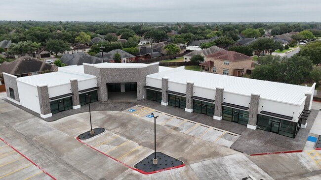
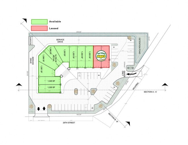
Property Record
7701 N 29Th St, Mcallen, TX 78504
NEARBY LISTINGS FOR SALE OR LEASE
Property Detail
7701 N 29Th St
McAllen/Edinburg/Pharr
Almon Estates
McAllen-Edinburg-Mission, TX
LA LOMITA (HOIT) AN IRR TR S247.10-N907.10-W472.40-E512.40 LOT 58 1.62 AC NET
A2681-00-000-0027-00
Hidalgo
Commercialnec
Texas
2024
58
2025
1.45 AC
020807
Greater McAllen
15,744 SF
DEMOGRAPHICS near 7701 N 29Th St
1 Mile
3 Mile
5 Mile
2024 Total Population
14,259
80,520
211,653
2029 Population
15,584
88,657
232,880
Pop Growth 2024-2029
+ 9.29%
+ 10.11%
+ 10.03%
Average Age
36
36
35
2024 Total Households
4,381
26,268
70,671
HH Growth 2024-2029
+ 9.22%
+ 10.14%
+ 10.08%
Median Household Inc
$73,866
$67,463
$56,872
Avg Household Size
3.20
3.00
2.90
2024 Avg HH Vehicles
2.00
2.00
2.00
Median Home Value
$170,111
$179,584
$172,236
Median Year Built
1999
1999
1998
Nearby Places
Map Layers
Map Styles
 Street
 Aerial
- Restaurants
- Banks
- Shops
- Fitness
- Groceries
PUBLIC TRANSPORTATION
AIRPORT
McAllen International
DRIVE
WALK
Distance
McAllen International
14 min
8.2 mi
Freight Ports
Port of Brownsville
DRIVE
WALK
Distance
Port of Brownsville
76 min
64.3 mi
SALE & LEASE HISTORY
LISTING DATE
SALE/LEASE

May 05, 2025
For Lease
Nearby Properties
Address
Land Use
TOTAL SIZE
Lot Size
Zoning
Address
Land Use
TOTAL SIZE
Lot Size
Zoning
407,190 SF
11.04 AC
CO
Address
Land Use
TOTAL SIZE
Lot Size
Zoning
357,818 SF
11.10 AC
Address
Land Use
TOTAL SIZE
Lot Size
Zoning
251,423 SF
27.39 AC
CO
Address
Land Use
TOTAL SIZE
Lot Size
Zoning
128,076 SF
5.01 AC
Address
Land Use
TOTAL SIZE
Lot Size
Zoning
125,254 SF
15 AC
C
Address
Land Use
TOTAL SIZE
Lot Size
Zoning
208,113 SF
22.75 AC
Address
Land Use
TOTAL SIZE
Lot Size
Zoning
173,217 SF
5.58 AC
Address
Land Use
TOTAL SIZE
Lot Size
Zoning
40,248 SF
10.36 AC
Address
Land Use
TOTAL SIZE
Lot Size
Zoning
205,008 SF
22.13 AC
Address
Land Use
TOTAL SIZE
Lot Size
Zoning
115,360 SF
4.70 AC
Address
Land Use
TOTAL SIZE
Lot Size
Zoning
352,875 SF
81.07 AC
Address
Land Use
TOTAL SIZE
Lot Size
Zoning
92,603 SF
7.10 AC
CO
Address
Land Use
TOTAL SIZE
Lot Size
Zoning
135,878 SF
15.45 AC
Address
Land Use
TOTAL SIZE
Lot Size
Zoning
90,172 SF
8.71 AC
Address
Land Use
TOTAL SIZE
Lot Size
Zoning
2.38 AC
RS
Address
Land Use
TOTAL SIZE
Lot Size
Zoning
1 SF
37.01 AC
Address
Land Use
TOTAL SIZE
Lot Size
Zoning
82,724 SF
3.27 AC
Address
Land Use
TOTAL SIZE
Lot Size
Zoning
138,653 SF
22.89 AC
Address
Land Use
TOTAL SIZE
Lot Size
Zoning
95,245 SF
8.92 AC
C-3
Address
Land Use
TOTAL SIZE
Lot Size
Zoning
54,270 SF
29 AC
Address
Land Use
TOTAL SIZE
Lot Size
Zoning
3 SF
14.43 AC
Address
Land Use
TOTAL SIZE
Lot Size
Zoning
62,624 SF
8.80 AC
Address
Land Use
TOTAL SIZE
Lot Size
Zoning
1 SF
20.84 AC
Address
Land Use
TOTAL SIZE
Lot Size
Zoning
125,693 SF
11.17 AC
CO
Address
Land Use
TOTAL SIZE
Lot Size
Zoning
70,306 SF
2.83 AC
RS
Address
Land Use
TOTAL SIZE
Lot Size
Zoning
97,478 SF
7.84 AC
CO
Address
Land Use
TOTAL SIZE
Lot Size
Zoning
139,407 SF
11.13 AC
Address
Land Use
TOTAL SIZE
Lot Size
Zoning
91,918 SF
8.92 AC
CO
Address
Land Use
TOTAL SIZE
Lot Size
Zoning
2 SF
24.89 AC
Address
Land Use
TOTAL SIZE
Lot Size
Zoning
88,592 SF
8.62 AC
The World's #1 Commercial Real Estate Marketplace
Connect with us
© 2025 CoStar Group
The information above has been obtained from sources believed reliable. While we do not doubt its accuracy we have not verified it and make no guarantee, warranty or representation about it. It is your responsibility to independently confirm its accuracy and completeness. Any projections, opinions, assumptions, or estimates used are for example only and do not represent the current or future performance of the property. The value of this transaction to you depends on tax and other factors which should be evaluated by your tax, financial, and legal advisors. You and your advisors should conduct a careful, independent investigation of the property to determine to your satisfaction the suitability of the property for your needs.