Property Record
7701 S Dearing Rd, Covington, GA 30014


This Property Is For Sale
Property Detail
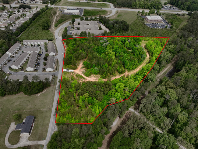
7701 S Dearing Rd
Atlanta-Sandy Springs-Roswell, GA
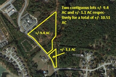
10.51AC DEARING RD
0082000000004A00
NEWTON
Commercialacreage
Georgia
B and X Area of moderate flood hazard, usually the area between the limits of the 100-year and 500-year floods.
10.51 AC
2025
Newton County
2025
Atlanta
100302
NEARBY LISTINGS FOR SALE OR LEASE
DEMOGRAPHICS near 7701 S Dearing Rd
1 mile
3 mile
5 mile
2025 Total Population
6,081
23,302
46,601
2030 Population
6,684
25,501
50,995
Pop Growth 2025-2030
+ 9.92%
+ 9.44%
+ 9.43%
Average Age
38
38
38
2025 Total Households
2,139
8,731
16,912
HH Growth 2025-2030
+ 10.05%
+ 9.59%
+ 9.56%
Median Household Inc
$86,823
$74,507
$73,655
Avg Household Size
2.80
2.60
2.60
2025 Avg HH Vehicles
2.00
2.00
2.00
Median Home Value
$310,966
$291,792
$272,162
Median Year Built
2002
1995
1994
Nearby Places
Map Layers
Map Styles
 Street
 Aerial
Layers
 Traffic
 Biking
Places
Listings with unknown addresses are not visible on the map
- Restaurants
- Banks
- Shops
- Fitness
- Groceries
Nearby Properties
Address
Land Use
TOTAL SIZE
Lot Size
Zoning
Address
Land Use
TOTAL SIZE
Lot Size
Zoning
359,785 SF
107 AC
Address
Land Use
TOTAL SIZE
Lot Size
Zoning
207,237 SF
10.61 AC
E1
Address
Land Use
TOTAL SIZE
Lot Size
Zoning
258,254 SF
15.08 AC
C1
Address
Land Use
TOTAL SIZE
Lot Size
Zoning
6,664 SF
17.75 AC
Address
Land Use
TOTAL SIZE
Lot Size
Zoning
214,590 SF
39.68 AC
Address
Land Use
TOTAL SIZE
Lot Size
Zoning
793,200 SF
63.82 AC
Address
Land Use
TOTAL SIZE
Lot Size
Zoning
45,900 AC
Address
Land Use
TOTAL SIZE
Lot Size
Zoning
88,944 SF
0.98 AC
E1
Address
Land Use
TOTAL SIZE
Lot Size
Zoning
591,770 SF
37.73 AC
I1
Address
Land Use
TOTAL SIZE
Lot Size
Zoning
28,884 SF
38.23 AC
C1
Address
Land Use
TOTAL SIZE
Lot Size
Zoning
10,000 SF
0.01 AC
Address
Land Use
TOTAL SIZE
Lot Size
Zoning
262,782 SF
20.94 AC
Address
Land Use
TOTAL SIZE
Lot Size
Zoning
1,627 SF
16.62 AC
C1
Address
Land Use
TOTAL SIZE
Lot Size
Zoning
123,360 SF
109.16 AC
I1
Address
Land Use
TOTAL SIZE
Lot Size
Zoning
14,080 SF
10 AC
C1
Address
Land Use
TOTAL SIZE
Lot Size
Zoning
150,000 SF
34.05 AC
Address
Land Use
TOTAL SIZE
Lot Size
Zoning
222,056 SF
13.35 AC
Address
Land Use
TOTAL SIZE
Lot Size
Zoning
202,240 SF
30.89 AC
C1
Address
Land Use
TOTAL SIZE
Lot Size
Zoning
28,790 SF
3.70 AC
E1
Address
Land Use
TOTAL SIZE
Lot Size
Zoning
33,550 SF
37.40 AC
I1
Address
Land Use
TOTAL SIZE
Lot Size
Zoning
48,144 SF
1.50 AC
E1
Address
Land Use
TOTAL SIZE
Lot Size
Zoning
159,034 SF
68.30 AC
E6
Address
Land Use
TOTAL SIZE
Lot Size
Zoning
169,660 SF
35.21 AC
I1
Address
Land Use
TOTAL SIZE
Lot Size
Zoning
31,376 SF
3.50 AC
PUD
Address
Land Use
TOTAL SIZE
Lot Size
Zoning
41,772 SF
28.03 AC
E6
Address
Land Use
TOTAL SIZE
Lot Size
Zoning
28,512 SF
0.52 AC
Address
Land Use
TOTAL SIZE
Lot Size
Zoning
69,487 SF
18.83 AC
C1
Address
Land Use
TOTAL SIZE
Lot Size
Zoning
3,128 SF
5.68 AC
C1
Address
Land Use
TOTAL SIZE
Lot Size
Zoning
27,492 SF
0.47 AC
Address
Land Use
TOTAL SIZE
Lot Size
Zoning
74,713 SF
2.83 AC
The World's #1 Commercial Real Estate Marketplace
Connect with us
© 2026 CoStar Group
The information above has been obtained from sources believed reliable. While we do not doubt its accuracy we have not verified it and make no guarantee, warranty or representation about it. It is your responsibility to independently confirm its accuracy and completeness. Any projections, opinions, assumptions, or estimates used are for example only and do not represent the current or future performance of the property. The value of this transaction to you depends on tax and other factors which should be evaluated by your tax, financial, and legal advisors. You and your advisors should conduct a careful, independent investigation of the property to determine to your satisfaction the suitability of the property for your needs.