Property Record
7702 Duffield Rd, Moxee, WA 98936
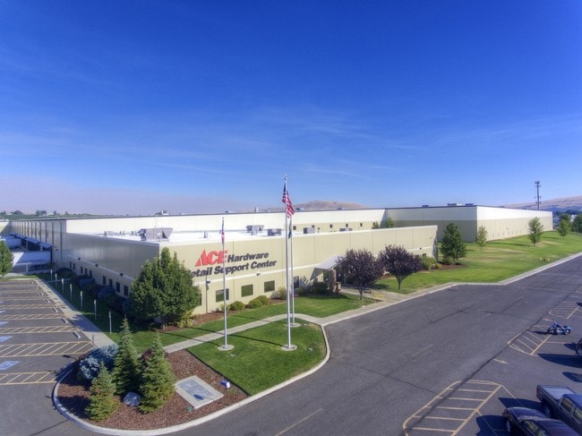
Property Detail
7702 Duffield Rd
191336-32003
W1/2 NW1/4 SW1/4 EX CO RD & EX TH PT LY SLY MOXEE CAN
Wholesaleoutletdiscountstore
Yakima
M1
Washington
B and X Area of moderate flood hazard, usually the area between the limits of the 100-year and 500-year floods.
18.86 AC
2026
Outlying Yakima County
2026
Yakima
001702
Yakima, WA
807,762 SF
NEARBY LISTINGS FOR SALE OR LEASE
DEMOGRAPHICS near 7702 Duffield Rd
1 mile
3 mile
5 mile
2025 Total Population
1,765
10,088
30,901
2030 Population
1,820
10,162
31,154
Pop Growth 2025-2030
+ 3.12%
+ 0.73%
+ 0.82%
Average Age
37
39
37
2025 Total Households
579
3,471
10,519
HH Growth 2025-2030
+ 3.11%
+ 0.86%
+ 0.91%
Median Household Inc
$81,851
$92,942
$72,427
Avg Household Size
3.00
2.90
2.90
2025 Avg HH Vehicles
3.00
3.00
2.00
Median Home Value
$374,427
$382,241
$326,441
Median Year Built
1995
1991
1983
Nearby Places
Map Layers
Map Styles
 Street
 Aerial
Layers
 Traffic
 Biking
Places
Listings with unknown addresses are not visible on the map
- Restaurants
- Banks
- Shops
- Fitness
- Groceries
PUBLIC TRANSPORTATION
AIRPORT
Yakima Air Trml/McAllister Field
Drive
Walk
Distance
Yakima Air Trml/McAllister Field
20 min
9.0 mi
Freight Ports
Port of Tacoma
Drive
Walk
Distance
Port of Tacoma
192 min
161.0 mi
SALE & LEASE HISTORY
LISTING DATE
SALE/LEASE

Sep 13, 2017
For Sale
Nearby Properties
Address
Land Use
TOTAL SIZE
Lot Size
Zoning
Address
Land Use
TOTAL SIZE
Lot Size
Zoning
295,494 SF
32.20 AC
R1
Address
Land Use
TOTAL SIZE
Lot Size
Zoning
391,380 SF
49.98 AC
AG
Address
Land Use
TOTAL SIZE
Lot Size
Zoning
184,623 SF
9.61 AC
M1
Address
Land Use
TOTAL SIZE
Lot Size
Zoning
343,692 SF
36.79 AC
AG
Address
Land Use
TOTAL SIZE
Lot Size
Zoning
102,104 SF
12.58 AC
PUB
Address
Land Use
TOTAL SIZE
Lot Size
Zoning
77,472 SF
33.76 AC
R1
Address
Land Use
TOTAL SIZE
Lot Size
Zoning
341,658 SF
19.75 AC
AG
Address
Land Use
TOTAL SIZE
Lot Size
Zoning
128,170 SF
9.68 AC
M1
Address
Land Use
TOTAL SIZE
Lot Size
Zoning
171,116 SF
12.77 AC
M1
Address
Land Use
TOTAL SIZE
Lot Size
Zoning
150,000 SF
16.97 AC
M1
Address
Land Use
TOTAL SIZE
Lot Size
Zoning
165,000 SF
19.05 AC
M1
Address
Land Use
TOTAL SIZE
Lot Size
Zoning
115,658 SF
20.69 AC
AG
Address
Land Use
TOTAL SIZE
Lot Size
Zoning
17,136 SF
52.87 AC
SR
Address
Land Use
TOTAL SIZE
Lot Size
Zoning
54,470 SF
6.07 AC
M1
Address
Land Use
TOTAL SIZE
Lot Size
Zoning
65,524 SF
4.68 AC
M1
Address
Land Use
TOTAL SIZE
Lot Size
Zoning
73,628 SF
8.20 AC
AG
Address
Land Use
TOTAL SIZE
Lot Size
Zoning
73,790 SF
6.31 AC
AG
Address
Land Use
TOTAL SIZE
Lot Size
Zoning
59,860 SF
63.19 AC
AG
Address
Land Use
TOTAL SIZE
Lot Size
Zoning
44,880 SF
5.01 AC
M1
Address
Land Use
TOTAL SIZE
Lot Size
Zoning
57,546 SF
35.31 AC
AG
Address
Land Use
TOTAL SIZE
Lot Size
Zoning
60,800 SF
4.88 AC
M1
Address
Land Use
TOTAL SIZE
Lot Size
Zoning
32,692 SF
220.23 AC
R10/5
Address
Land Use
TOTAL SIZE
Lot Size
Zoning
24,659 SF
2.48 AC
R3
Address
Land Use
TOTAL SIZE
Lot Size
Zoning
29,460 SF
27.67 AC
M1
Address
Land Use
TOTAL SIZE
Lot Size
Zoning
71,787 SF
4.01 AC
M1
Address
Land Use
TOTAL SIZE
Lot Size
Zoning
11,074 SF
242.66 AC
AG
Address
Land Use
TOTAL SIZE
Lot Size
Zoning
17,869 SF
33.96 AC
AG
Address
Land Use
TOTAL SIZE
Lot Size
Zoning
14,964 SF
1.55 AC
C2
Address
Land Use
TOTAL SIZE
Lot Size
Zoning
41,182 SF
5.20 AC
AG
The World's #1 Commercial Real Estate Marketplace
Connect with us
© 2026 CoStar Group
The information above has been obtained from sources believed reliable. While we do not doubt its accuracy we have not verified it and make no guarantee, warranty or representation about it. It is your responsibility to independently confirm its accuracy and completeness. Any projections, opinions, assumptions, or estimates used are for example only and do not represent the current or future performance of the property. The value of this transaction to you depends on tax and other factors which should be evaluated by your tax, financial, and legal advisors. You and your advisors should conduct a careful, independent investigation of the property to determine to your satisfaction the suitability of the property for your needs.