Property Record
7702 Jacks Way, Horace, ND 58047
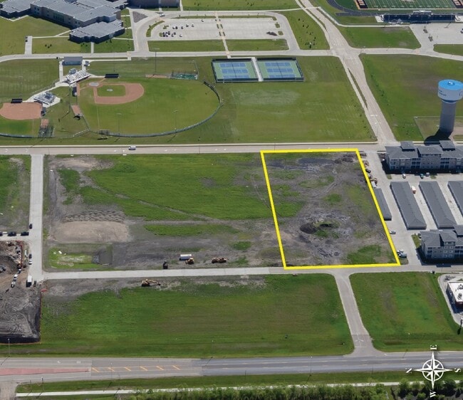

This Property Is For Sale
Property Detail
7702 Jacks Way
Fargo, ND-MN
LOT: 2 BLOCK: 1 ADDITION: LAKEVIEW HEIGHTS 5TH ADDITION ADDITIONAL: LAKEVIEW HEIGHTS 5TH ADDN LT 2 BLK 1 **9-16-22 REPLAT FRM 15-0360-00010-010 & 020, 00020-000, 00030-000, 15-0379-00010-000 & 15-0381-00010-000 PER PLAT DOC#1673385 FOR 2022
15-0382-00020-000
CASS
Miscellaneous
North Dakota
2024
2
2024
Fargo
040503
Other Market Areas
NEARBY LISTINGS FOR SALE OR LEASE
-
-
County Road 17 @ Christianson Boulevard
Horace, ND 58047
$2,551,572 - $9,232,768
4.88 - 9.84 AC Lot
Land
-
-
View all Horace listings for sale on LoopNet.com
DEMOGRAPHICS near 7702 Jacks Way
1 mile
3 mile
5 mile
2025 Total Population
2,187
13,519
66,836
2030 Population
2,476
14,790
72,268
Pop Growth 2025-2030
+ 13.21%
+ 9.40%
+ 8.13%
Average Age
36
33
33
2025 Total Households
753
4,670
26,293
HH Growth 2025-2030
+ 13.68%
+ 9.76%
+ 8.42%
Median Household Inc
$124,195
$124,005
$100,836
Avg Household Size
2.90
2.90
2.50
2025 Avg HH Vehicles
3.00
2.00
2.00
Median Home Value
$350,000
$437,748
$387,435
Median Year Built
2010
2010
2010
Nearby Places
Map Layers
Map Styles
 Street
 Aerial
Layers
 Traffic
 Biking
Places
Listings with unknown addresses are not visible on the map
- Restaurants
- Banks
- Shops
- Fitness
- Groceries
PUBLIC TRANSPORTATION
AIRPORT
Hector International
Drive
Walk
Distance
Hector International
27 min
16.1 mi
Freight Ports
Port Milwaukee
Drive
Walk
Distance
Port Milwaukee
641 min
581.6 mi
Nearby Properties
Address
Land Use
TOTAL SIZE
Lot Size
Zoning
Address
Land Use
TOTAL SIZE
Lot Size
Zoning
7.66 AC
Address
Land Use
TOTAL SIZE
Lot Size
Zoning
42,366 SF
Address
Land Use
TOTAL SIZE
Lot Size
Zoning
18.05 AC
Address
Land Use
TOTAL SIZE
Lot Size
Zoning
Address
Land Use
TOTAL SIZE
Lot Size
Zoning
Address
Land Use
TOTAL SIZE
Lot Size
Zoning
1,784 SF
Address
Land Use
TOTAL SIZE
Lot Size
Zoning
Address
Land Use
TOTAL SIZE
Lot Size
Zoning
Address
Land Use
TOTAL SIZE
Lot Size
Zoning
Address
Land Use
TOTAL SIZE
Lot Size
Zoning
Address
Land Use
TOTAL SIZE
Lot Size
Zoning
55,062 SF
3.67 AC
GC
Address
Land Use
TOTAL SIZE
Lot Size
Zoning
Address
Land Use
TOTAL SIZE
Lot Size
Zoning
53,272 SF
9.34 AC
Address
Land Use
TOTAL SIZE
Lot Size
Zoning
36,042 SF
1.92 AC
MR2
Address
Land Use
TOTAL SIZE
Lot Size
Zoning
3.17 AC
Address
Land Use
TOTAL SIZE
Lot Size
Zoning
3,200 SF
1.98 AC
Address
Land Use
TOTAL SIZE
Lot Size
Zoning
21,576 SF
Address
Land Use
TOTAL SIZE
Lot Size
Zoning
54,170 SF
2.51 AC
MR3
Address
Land Use
TOTAL SIZE
Lot Size
Zoning
56,112 SF
2.65 AC
MR3
Address
Land Use
TOTAL SIZE
Lot Size
Zoning
52,992 SF
2.77 AC
MR3
Address
Land Use
TOTAL SIZE
Lot Size
Zoning
54,170 SF
2.21 AC
MR3
Address
Land Use
TOTAL SIZE
Lot Size
Zoning
54,741 SF
2.48 AC
MR3
Address
Land Use
TOTAL SIZE
Lot Size
Zoning
54,741 SF
2.38 AC
MR3
Address
Land Use
TOTAL SIZE
Lot Size
Zoning
54,170 SF
2.24 AC
MR3
Address
Land Use
TOTAL SIZE
Lot Size
Zoning
1,812 SF
76.82 AC
Address
Land Use
TOTAL SIZE
Lot Size
Zoning
4.07 AC
Address
Land Use
TOTAL SIZE
Lot Size
Zoning
1.87 AC
Address
Land Use
TOTAL SIZE
Lot Size
Zoning
Address
Land Use
TOTAL SIZE
Lot Size
Zoning
3,320 SF
3.48 AC
GC
Address
Land Use
TOTAL SIZE
Lot Size
Zoning
The World's #1 Commercial Real Estate Marketplace
Connect with us
© 2026 CoStar Group
The information above has been obtained from sources believed reliable. While we do not doubt its accuracy we have not verified it and make no guarantee, warranty or representation about it. It is your responsibility to independently confirm its accuracy and completeness. Any projections, opinions, assumptions, or estimates used are for example only and do not represent the current or future performance of the property. The value of this transaction to you depends on tax and other factors which should be evaluated by your tax, financial, and legal advisors. You and your advisors should conduct a careful, independent investigation of the property to determine to your satisfaction the suitability of the property for your needs.