Property Record
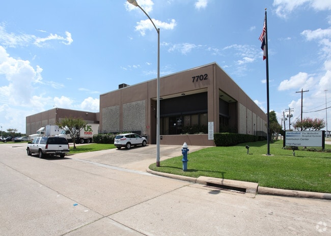
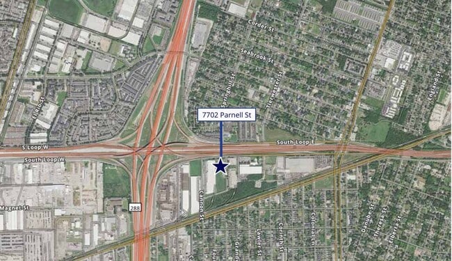
7702 Parnell St, Houston, TX 77021

This Property Is For Sale
Current Lease Availabilities
Property Detail
7702 Parnell St
1020440000002
TR 2A BLK 2 SOUTH LOOP BUSINESS PARK
Warehouse
HARRIS
B and X Area of moderate flood hazard, usually the area between the limits of the 100-year and 500-year floods.
Texas
0
2.57 AC
2025
South Hwy 35
331100
Houston
47,375 SF
Houston-Pasadena-The Woodlands, TX
NEARBY LISTINGS FOR SALE OR LEASE
DEMOGRAPHICS near 7702 Parnell St
1 mile
3 mile
5 mile
2024 Total Population
14,994
146,472
416,702
2029 Population
16,243
158,466
449,572
Pop Growth 2024-2029
+ 8.33%
+ 8.19%
+ 7.89%
Average Age
36
37
37
2024 Total Households
6,227
62,818
174,852
HH Growth 2024-2029
+ 8.35%
+ 8.51%
+ 8.39%
Median Household Inc
$52,023
$54,424
$69,805
Avg Household Size
2.40
2.20
2.20
2024 Avg HH Vehicles
1.00
1.00
2.00
Median Home Value
$225,031
$230,981
$336,833
Median Year Built
1987
1984
1988
Nearby Places
Map Layers
Map Styles
 Street
 Aerial
Transit
 Traffic
 Biking
Places
Listings with unknown addresses are not visible on the map
- Restaurants
- Banks
- Shops
- Fitness
- Groceries
PUBLIC TRANSPORTATION
COMMUTER RAIL
Houston (Sunset Limited - Amtrak)
Drive
Walk
Distance
Houston (Sunset Limited - Amtrak)
14 min
8.2 mi
AIRPORT
William P Hobby
Drive
Walk
Distance
William P Hobby
20 min
9.9 mi
George Bush Intcntl/Houston
Drive
Walk
Distance
George Bush Intcntl/Houston
34 min
25.4 mi
Freight Ports
Port of Houston
Drive
Walk
Distance
Port of Houston
17 min
10.2 mi
Nearby Properties
Address
Land Use
TOTAL SIZE
Lot Size
Zoning
Address
Land Use
TOTAL SIZE
Lot Size
Zoning
519,409 SF
1.52 AC
Address
Land Use
TOTAL SIZE
Lot Size
Zoning
1,252,274 SF
2.02 AC
Address
Land Use
TOTAL SIZE
Lot Size
Zoning
704,249 SF
2.34 AC
Address
Land Use
TOTAL SIZE
Lot Size
Zoning
1,359,194 SF
Address
Land Use
TOTAL SIZE
Lot Size
Zoning
402,467 SF
28.30 AC
Address
Land Use
TOTAL SIZE
Lot Size
Zoning
577,327 SF
28.80 AC
Address
Land Use
TOTAL SIZE
Lot Size
Zoning
396,888 SF
2.02 AC
Address
Land Use
TOTAL SIZE
Lot Size
Zoning
486,076 SF
3.79 AC
Address
Land Use
TOTAL SIZE
Lot Size
Zoning
527,457 SF
6.21 AC
Address
Land Use
TOTAL SIZE
Lot Size
Zoning
499,411 SF
5.73 AC
Address
Land Use
TOTAL SIZE
Lot Size
Zoning
706,892 SF
5.86 AC
Address
Land Use
TOTAL SIZE
Lot Size
Zoning
562,131 SF
4.11 AC
Address
Land Use
TOTAL SIZE
Lot Size
Zoning
356,610 SF
2.26 AC
Address
Land Use
TOTAL SIZE
Lot Size
Zoning
557,397 SF
5.58 AC
Address
Land Use
TOTAL SIZE
Lot Size
Zoning
353,738 SF
2.04 AC
Address
Land Use
TOTAL SIZE
Lot Size
Zoning
651,551 SF
52.18 AC
Address
Land Use
TOTAL SIZE
Lot Size
Zoning
372,028 SF
26.56 AC
Address
Land Use
TOTAL SIZE
Lot Size
Zoning
284,836 SF
4.22 AC
Address
Land Use
TOTAL SIZE
Lot Size
Zoning
499,978 SF
5.57 AC
Address
Land Use
TOTAL SIZE
Lot Size
Zoning
643,698 SF
6.57 AC
Address
Land Use
TOTAL SIZE
Lot Size
Zoning
354,377 SF
8.10 AC
Address
Land Use
TOTAL SIZE
Lot Size
Zoning
410,109 SF
0.69 AC
Address
Land Use
TOTAL SIZE
Lot Size
Zoning
365,485 SF
13.94 AC
Address
Land Use
TOTAL SIZE
Lot Size
Zoning
397,924 SF
3.64 AC
Address
Land Use
TOTAL SIZE
Lot Size
Zoning
380,761 SF
0.92 AC
Address
Land Use
TOTAL SIZE
Lot Size
Zoning
257,963 SF
6.39 AC
Address
Land Use
TOTAL SIZE
Lot Size
Zoning
518,025 SF
18.09 AC
Address
Land Use
TOTAL SIZE
Lot Size
Zoning
53,600 SF
21.34 AC
Address
Land Use
TOTAL SIZE
Lot Size
Zoning
474,970 SF
6.95 AC
Address
Land Use
TOTAL SIZE
Lot Size
Zoning
460,438 SF
3.37 AC
The World's #1 Commercial Real Estate Marketplace
Connect with us
© 2026 CoStar Group
The information above has been obtained from sources believed reliable. While we do not doubt its accuracy we have not verified it and make no guarantee, warranty or representation about it. It is your responsibility to independently confirm its accuracy and completeness. Any projections, opinions, assumptions, or estimates used are for example only and do not represent the current or future performance of the property. The value of this transaction to you depends on tax and other factors which should be evaluated by your tax, financial, and legal advisors. You and your advisors should conduct a careful, independent investigation of the property to determine to your satisfaction the suitability of the property for your needs.