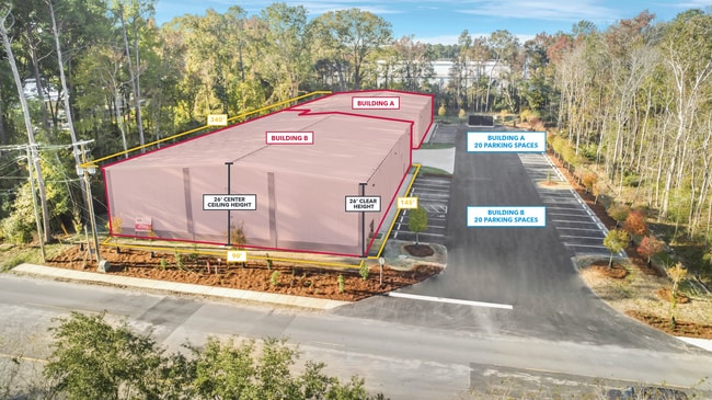
Property Record
S Rail Rd, North Charleston, SC 29420


NEARBY LISTINGS FOR SALE OR LEASE
Property Detail
S Rail Rd
Charleston/N Charleston
North Charleston
Charleston-North Charleston, SC
MAPPLATB L23 MAPPLATP 0266 SUBDIVISIONNAME NORTH CHARLESTON LOT B-5
484-00-00-541
Charleston
Commercialacreage
South Carolina
2025
b-5
2024
2.47 AC
010818
North Charleston
DEMOGRAPHICS near S Rail Rd
1 Mile
3 Mile
5 Mile
2024 Total Population
6,238
54,930
154,669
2029 Population
6,604
59,000
170,469
Pop Growth 2024-2029
+ 5.87%
+ 7.41%
+ 10.22%
Average Age
37
36
37
2024 Total Households
2,499
21,522
59,478
HH Growth 2024-2029
+ 5.84%
+ 7.23%
+ 10.07%
Median Household Inc
$53,500
$54,071
$65,224
Avg Household Size
2.30
2.40
2.50
2024 Avg HH Vehicles
2.00
2.00
2.00
Median Home Value
$180,450
$227,481
$237,606
Median Year Built
1986
1994
1994
Nearby Places
Map Layers
Map Styles
 Street
 Aerial
- Restaurants
- Banks
- Shops
- Fitness
- Groceries
PUBLIC TRANSPORTATION
COMMUTER RAIL
Charleston Amtrak Station (Palmetto - Amtrak, Silver Meteor - Amtrak)
DRIVE
WALK
Distance
Charleston Amtrak Station (Palmetto - Amtrak, Silver Meteor - Amtrak)
13 min
7.4 mi
AIRPORT
Charleston AFB/International
DRIVE
WALK
Distance
Charleston AFB/International
15 min
6.4 mi
Freight Ports
North Charleston Terminal
DRIVE
WALK
Distance
North Charleston Terminal
13 min
7.0 mi
SALE & LEASE HISTORY
LISTING DATE
SALE/LEASE

Sep 10, 2024
For Lease
Apr 17, 2024
For Lease
Nearby Properties
Address
Land Use
TOTAL SIZE
Lot Size
Zoning
Address
Land Use
TOTAL SIZE
Lot Size
Zoning
Address
Land Use
TOTAL SIZE
Lot Size
Zoning
48.89 AC
Address
Land Use
TOTAL SIZE
Lot Size
Zoning
1,430 SF
28.27 AC
Address
Land Use
TOTAL SIZE
Lot Size
Zoning
2,917 SF
11.76 AC
HANAHAN -
Address
Land Use
TOTAL SIZE
Lot Size
Zoning
Address
Land Use
TOTAL SIZE
Lot Size
Zoning
10,172 SF
12.76 AC
Address
Land Use
TOTAL SIZE
Lot Size
Zoning
7,200 SF
8.73 AC
Address
Land Use
TOTAL SIZE
Lot Size
Zoning
28,770 SF
15.53 AC
Address
Land Use
TOTAL SIZE
Lot Size
Zoning
14.75 AC
Address
Land Use
TOTAL SIZE
Lot Size
Zoning
16.40 AC
Address
Land Use
TOTAL SIZE
Lot Size
Zoning
16.53 AC
Address
Land Use
TOTAL SIZE
Lot Size
Zoning
4,320 SF
8.14 AC
HANAHAN -
Address
Land Use
TOTAL SIZE
Lot Size
Zoning
1,272 SF
18.46 AC
Address
Land Use
TOTAL SIZE
Lot Size
Zoning
33.62 AC
Address
Land Use
TOTAL SIZE
Lot Size
Zoning
14.33 AC
Address
Land Use
TOTAL SIZE
Lot Size
Zoning
101,011 SF
6.58 AC
Address
Land Use
TOTAL SIZE
Lot Size
Zoning
199,300 SF
13.28 AC
Address
Land Use
TOTAL SIZE
Lot Size
Zoning
Address
Land Use
TOTAL SIZE
Lot Size
Zoning
126,385 SF
13.45 AC
Address
Land Use
TOTAL SIZE
Lot Size
Zoning
14,725 SF
3.55 AC
Address
Land Use
TOTAL SIZE
Lot Size
Zoning
Address
Land Use
TOTAL SIZE
Lot Size
Zoning
133.75 AC
MUC_DC
Address
Land Use
TOTAL SIZE
Lot Size
Zoning
34,131 SF
0.89 AC
Address
Land Use
TOTAL SIZE
Lot Size
Zoning
67,082 SF
12.07 AC
Address
Land Use
TOTAL SIZE
Lot Size
Zoning
48,400 SF
5.76 AC
Address
Land Use
TOTAL SIZE
Lot Size
Zoning
167,100 SF
8 AC
Address
Land Use
TOTAL SIZE
Lot Size
Zoning
58,444 SF
5.61 AC
Address
Land Use
TOTAL SIZE
Lot Size
Zoning
44,300 SF
2.34 AC
Address
Land Use
TOTAL SIZE
Lot Size
Zoning
1,925 SF
8.37 AC
HANAHAN -
Address
Land Use
TOTAL SIZE
Lot Size
Zoning
33.88 AC
The World's #1 Commercial Real Estate Marketplace
Connect with us
© 2026 CoStar Group
The information above has been obtained from sources believed reliable. While we do not doubt its accuracy we have not verified it and make no guarantee, warranty or representation about it. It is your responsibility to independently confirm its accuracy and completeness. Any projections, opinions, assumptions, or estimates used are for example only and do not represent the current or future performance of the property. The value of this transaction to you depends on tax and other factors which should be evaluated by your tax, financial, and legal advisors. You and your advisors should conduct a careful, independent investigation of the property to determine to your satisfaction the suitability of the property for your needs.