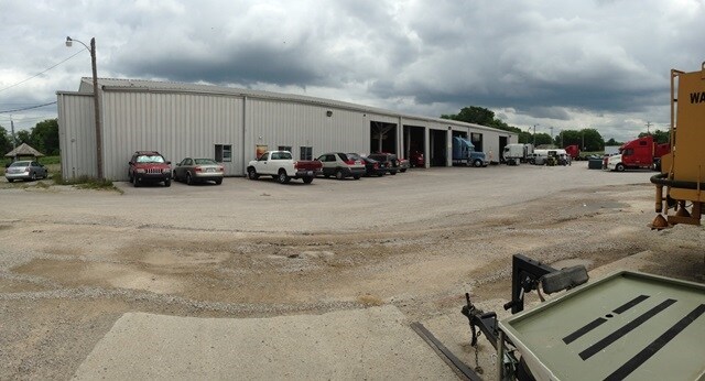
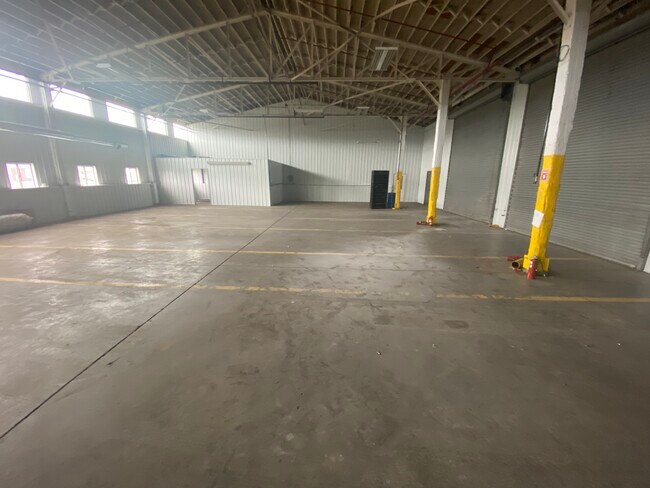
Property Record
771 Brownslock Rd, Bowling Green, KY 42101

Property Detail
771 Brownslock Rd
039B-28-005A
Warren
Commercialnec
Kentucky
B and X Area of moderate flood hazard, usually the area between the limits of the 100-year and 500-year floods.
1
2025
3.49 AC
2025
Bowling Green Area
010300
Other Market Areas
12,800 SF
Bowling Green, KY
NEARBY LISTINGS FOR SALE OR LEASE
DEMOGRAPHICS near 771 Brownslock Rd
1 mile
3 mile
5 mile
2025 Total Population
10,365
49,051
88,451
2030 Population
11,385
53,262
96,283
Pop Growth 2025-2030
+ 9.84%
+ 8.58%
+ 8.85%
Average Age
33
34
35
2025 Total Households
3,853
18,611
35,132
HH Growth 2025-2030
+ 10.80%
+ 9.52%
+ 9.67%
Median Household Inc
$32,500
$46,082
$51,411
Avg Household Size
2.40
2.30
2.30
2025 Avg HH Vehicles
1.00
2.00
2.00
Median Home Value
$132,894
$232,790
$254,371
Median Year Built
1976
1981
1989
Nearby Places
Map Layers
Map Styles
 Street
 Aerial
Layers
 Traffic
 Biking
Places
Listings with unknown addresses are not visible on the map
- Restaurants
- Banks
- Shops
- Fitness
- Groceries
SALE & LEASE HISTORY
LISTING DATE
SALE/LEASE

Sep 24, 2020
For Lease
May 08, 2020
For Sale
Nearby Properties
Address
Land Use
TOTAL SIZE
Lot Size
Zoning
Address
Land Use
TOTAL SIZE
Lot Size
Zoning
15,440 SF
16.52 AC
Address
Land Use
TOTAL SIZE
Lot Size
Zoning
117,551 SF
5.06 AC
Address
Land Use
TOTAL SIZE
Lot Size
Zoning
261,579 SF
17.71 AC
Address
Land Use
TOTAL SIZE
Lot Size
Zoning
150,327 SF
2.54 AC
Address
Land Use
TOTAL SIZE
Lot Size
Zoning
36,984 SF
7.26 AC
Address
Land Use
TOTAL SIZE
Lot Size
Zoning
93,730 SF
4.05 AC
Address
Land Use
TOTAL SIZE
Lot Size
Zoning
19.61 AC
Address
Land Use
TOTAL SIZE
Lot Size
Zoning
142,199 SF
12.95 AC
Address
Land Use
TOTAL SIZE
Lot Size
Zoning
214,273 SF
26.97 AC
Address
Land Use
TOTAL SIZE
Lot Size
Zoning
Address
Land Use
TOTAL SIZE
Lot Size
Zoning
Address
Land Use
TOTAL SIZE
Lot Size
Zoning
Address
Land Use
TOTAL SIZE
Lot Size
Zoning
Address
Land Use
TOTAL SIZE
Lot Size
Zoning
2,946 SF
3.59 AC
Address
Land Use
TOTAL SIZE
Lot Size
Zoning
77,160 SF
3.05 AC
Address
Land Use
TOTAL SIZE
Lot Size
Zoning
38,782 SF
4.05 AC
Address
Land Use
TOTAL SIZE
Lot Size
Zoning
176,450 SF
18.60 AC
Address
Land Use
TOTAL SIZE
Lot Size
Zoning
1,101 SF
16.07 AC
Address
Land Use
TOTAL SIZE
Lot Size
Zoning
3,200 SF
8.61 AC
Address
Land Use
TOTAL SIZE
Lot Size
Zoning
3,120 SF
4.97 AC
Address
Land Use
TOTAL SIZE
Lot Size
Zoning
13,277 SF
1.21 AC
Address
Land Use
TOTAL SIZE
Lot Size
Zoning
214,845 SF
4.38 AC
Address
Land Use
TOTAL SIZE
Lot Size
Zoning
51,786 SF
2.25 AC
Address
Land Use
TOTAL SIZE
Lot Size
Zoning
19,047 SF
3.77 AC
Address
Land Use
TOTAL SIZE
Lot Size
Zoning
13,661 SF
6.25 AC
Address
Land Use
TOTAL SIZE
Lot Size
Zoning
43,663 SF
8.77 AC
Address
Land Use
TOTAL SIZE
Lot Size
Zoning
159,256 SF
11.44 AC
Address
Land Use
TOTAL SIZE
Lot Size
Zoning
62,052 SF
6.03 AC
Address
Land Use
TOTAL SIZE
Lot Size
Zoning
27,100 SF
8.43 AC
Address
Land Use
TOTAL SIZE
Lot Size
Zoning
4,608 SF
8 AC
The World's #1 Commercial Real Estate Marketplace
Connect with us
© 2026 CoStar Group
The information above has been obtained from sources believed reliable. While we do not doubt its accuracy we have not verified it and make no guarantee, warranty or representation about it. It is your responsibility to independently confirm its accuracy and completeness. Any projections, opinions, assumptions, or estimates used are for example only and do not represent the current or future performance of the property. The value of this transaction to you depends on tax and other factors which should be evaluated by your tax, financial, and legal advisors. You and your advisors should conduct a careful, independent investigation of the property to determine to your satisfaction the suitability of the property for your needs.