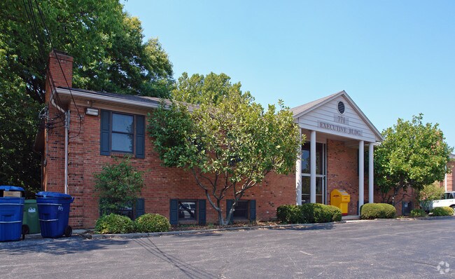
Property Record
771 Neeb Rd, Cincinnati, OH 45233

Current Lease Availabilities
Property Detail
771 Neeb Rd
540-0111-0239
NEEB RD 113.59 X 127.23 IRR LOT 1 VICTORY VIEW ESTATES SUB
Officebuilding
Hamilton
E
Ohio
B and X Area of moderate flood hazard, usually the area between the limits of the 100-year and 500-year floods.
1
2025
0.31 AC
2025
Forest Park/West
021302
Cincinnati/Dayton
3,200 SF
Cincinnati, OH-KY-IN
NEARBY LISTINGS FOR SALE OR LEASE
DEMOGRAPHICS near 771 Neeb Rd
1 mile
3 mile
5 mile
2025 Total Population
9,131
71,758
180,427
2030 Population
9,172
71,768
182,940
Pop Growth 2025-2030
+ 0.45%
+ 0.01%
+ 1.39%
Average Age
42
40
39
2025 Total Households
3,351
28,629
72,111
HH Growth 2025-2030
+ 0.60%
+ 0.07%
+ 1.37%
Median Household Inc
$91,370
$69,420
$64,669
Avg Household Size
2.50
2.40
2.40
2025 Avg HH Vehicles
2.00
2.00
2.00
Median Home Value
$242,040
$201,197
$206,264
Median Year Built
1969
1962
1963
Nearby Places
Map Layers
Map Styles
 Street
 Aerial
Layers
 Traffic
 Biking
Places
Listings with unknown addresses are not visible on the map
- Restaurants
- Banks
- Shops
- Fitness
- Groceries
PUBLIC TRANSPORTATION
COMMUTER RAIL
Drive
Walk
Distance
18 min
7.0 mi
AIRPORT
Cincinnati/Northern Kentucky International
Drive
Walk
Distance
Cincinnati/Northern Kentucky International
40 min
8.1 mi
Nearby Properties
Address
Land Use
TOTAL SIZE
Lot Size
Zoning
Address
Land Use
TOTAL SIZE
Lot Size
Zoning
177,092 SF
8.64 AC
Address
Land Use
TOTAL SIZE
Lot Size
Zoning
38.97 AC
Address
Land Use
TOTAL SIZE
Lot Size
Zoning
3.90 AC
RFC
Address
Land Use
TOTAL SIZE
Lot Size
Zoning
26.62 AC
Address
Land Use
TOTAL SIZE
Lot Size
Zoning
493,680 SF
25 AC
Address
Land Use
TOTAL SIZE
Lot Size
Zoning
458,800 SF
49.35 AC
Address
Land Use
TOTAL SIZE
Lot Size
Zoning
30.43 AC
AA
Address
Land Use
TOTAL SIZE
Lot Size
Zoning
426,420 SF
20.59 AC
Address
Land Use
TOTAL SIZE
Lot Size
Zoning
396,000 SF
24 AC
Address
Land Use
TOTAL SIZE
Lot Size
Zoning
136,000 SF
20.52 AC
Address
Land Use
TOTAL SIZE
Lot Size
Zoning
9.50 AC
Address
Land Use
TOTAL SIZE
Lot Size
Zoning
66,040 SF
22.34 AC
Address
Land Use
TOTAL SIZE
Lot Size
Zoning
5.89 AC
Address
Land Use
TOTAL SIZE
Lot Size
Zoning
316,800 SF
15.66 AC
Address
Land Use
TOTAL SIZE
Lot Size
Zoning
320,000 SF
18.50 AC
Address
Land Use
TOTAL SIZE
Lot Size
Zoning
217,800 SF
9.22 AC
Address
Land Use
TOTAL SIZE
Lot Size
Zoning
80,520 SF
10.85 AC
Address
Land Use
TOTAL SIZE
Lot Size
Zoning
116,160 SF
15.04 AC
Address
Land Use
TOTAL SIZE
Lot Size
Zoning
9.52 AC
B
Address
Land Use
TOTAL SIZE
Lot Size
Zoning
17,857 SF
26.60 AC
CGA
Address
Land Use
TOTAL SIZE
Lot Size
Zoning
12.28 AC
AA
Address
Land Use
TOTAL SIZE
Lot Size
Zoning
9.36 AC
Address
Land Use
TOTAL SIZE
Lot Size
Zoning
8.18 AC
SF4
Address
Land Use
TOTAL SIZE
Lot Size
Zoning
146,000 SF
9.35 AC
Address
Land Use
TOTAL SIZE
Lot Size
Zoning
13.44 AC
Address
Land Use
TOTAL SIZE
Lot Size
Zoning
122,854 SF
18.68 AC
Address
Land Use
TOTAL SIZE
Lot Size
Zoning
108,000 SF
6.87 AC
Address
Land Use
TOTAL SIZE
Lot Size
Zoning
106,920 SF
6.88 AC
Address
Land Use
TOTAL SIZE
Lot Size
Zoning
124,200 SF
7.29 AC
Address
Land Use
TOTAL SIZE
Lot Size
Zoning
58,910 SF
13.82 AC
The World's #1 Commercial Real Estate Marketplace
Connect with us
© 2026 CoStar Group
The information above has been obtained from sources believed reliable. While we do not doubt its accuracy we have not verified it and make no guarantee, warranty or representation about it. It is your responsibility to independently confirm its accuracy and completeness. Any projections, opinions, assumptions, or estimates used are for example only and do not represent the current or future performance of the property. The value of this transaction to you depends on tax and other factors which should be evaluated by your tax, financial, and legal advisors. You and your advisors should conduct a careful, independent investigation of the property to determine to your satisfaction the suitability of the property for your needs.