Property Record
7710 Osteen Rd, New Port Richey, FL 34653


NEARBY LISTINGS FOR SALE OR LEASE
-
-
View all New Port Richey listings for sale on LoopNet.com
Property Detail
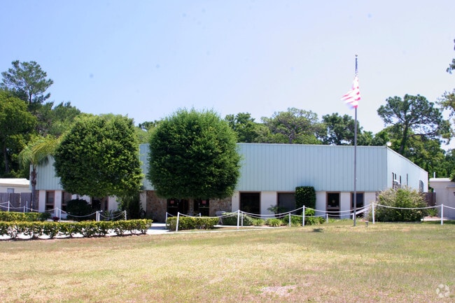
7710 Osteen Rd
Tampa-St. Petersburg-Clearwater, FL
Ridgewood
35-25-16-0000-02100-0000
COM AT NE COR OF SW 1/4 OF NW 1/4 OF SECTION TH S00DEG14 39W 237.00 FT FOR POB TH CONT S00DEG1439W 237.00 FT TH N89DEG3934W 519.38 FT TH N03DEG1459E 238.53 FT TH S89DEG3116E 506.87 FT TO POB NLY 15 FT & ELY 30 FT THEREOF SUBJECT TO EASEMENT FOR INGRE
Publicschool
Pasco
X
Florida
12101C0193F
1
0
8.67 AC
2026
Pasco County
030905
Tampa/St Petersburg
50,912 SF
DEMOGRAPHICS near 7710 Osteen Rd
1 Mile
3 Mile
5 Mile
2024 Total Population
8,084
73,967
165,205
2029 Population
9,604
88,404
198,173
Pop Growth 2024-2029
+ 18.80%
+ 19.52%
+ 19.96%
Average Age
44
44
45
2024 Total Households
3,522
31,835
71,776
HH Growth 2024-2029
+ 18.74%
+ 19.49%
+ 19.97%
Median Household Inc
$44,052
$46,455
$48,127
Avg Household Size
2.20
2.30
2.20
2024 Avg HH Vehicles
1.00
2.00
2.00
Median Home Value
$150,957
$169,759
$172,739
Median Year Built
1983
1981
1981
Nearby Places
Map Layers
Map Styles
 Street
 Aerial
- Restaurants
- Banks
- Shops
- Fitness
- Groceries
PUBLIC TRANSPORTATION
AIRPORT
St Pete-Clearwater International
DRIVE
WALK
Distance
St Pete-Clearwater International
59 min
31.7 mi
Tampa International
DRIVE
WALK
Distance
Tampa International
54 min
35.5 mi
Freight Ports
Port of Tampa Bay
DRIVE
WALK
Distance
Port of Tampa Bay
66 min
41.0 mi
Nearby Properties
Address
Land Use
TOTAL SIZE
Lot Size
Zoning
Address
Land Use
TOTAL SIZE
Lot Size
Zoning
395,386 SF
35.63 AC
C2
Address
Land Use
TOTAL SIZE
Lot Size
Zoning
799,241 SF
88.92 AC
PUD
Address
Land Use
TOTAL SIZE
Lot Size
Zoning
248,561 SF
14.17 AC
C
Address
Land Use
TOTAL SIZE
Lot Size
Zoning
229,050 SF
36.13 AC
MPUD
Address
Land Use
TOTAL SIZE
Lot Size
Zoning
351,012 SF
23.51 AC
MF2
Address
Land Use
TOTAL SIZE
Lot Size
Zoning
220,843 SF
35.13 AC
C2
Address
Land Use
TOTAL SIZE
Lot Size
Zoning
416,037 SF
50.65 AC
C1
Address
Land Use
TOTAL SIZE
Lot Size
Zoning
141,740 SF
22.84 AC
PO1
Address
Land Use
TOTAL SIZE
Lot Size
Zoning
162,716 SF
16.56 AC
MF1
Address
Land Use
TOTAL SIZE
Lot Size
Zoning
171,378 SF
17.35 AC
MF1
Address
Land Use
TOTAL SIZE
Lot Size
Zoning
149,162 SF
3.10 AC
C
Address
Land Use
TOTAL SIZE
Lot Size
Zoning
191,812 SF
17.61 AC
MPUD
Address
Land Use
TOTAL SIZE
Lot Size
Zoning
296,488 SF
92.09 AC
AC
Address
Land Use
TOTAL SIZE
Lot Size
Zoning
122,037 SF
13.83 AC
MF1
Address
Land Use
TOTAL SIZE
Lot Size
Zoning
121,284 SF
10.25 AC
MF1
Address
Land Use
TOTAL SIZE
Lot Size
Zoning
91,660 SF
16.29 AC
C
Address
Land Use
TOTAL SIZE
Lot Size
Zoning
220,045 SF
22.67 AC
C2
Address
Land Use
TOTAL SIZE
Lot Size
Zoning
309,759 SF
65.19 AC
AC
Address
Land Use
TOTAL SIZE
Lot Size
Zoning
183,139 SF
19.66 AC
C2
Address
Land Use
TOTAL SIZE
Lot Size
Zoning
217,350 SF
11.20 AC
PUD
Address
Land Use
TOTAL SIZE
Lot Size
Zoning
142,856 SF
20 AC
C
Address
Land Use
TOTAL SIZE
Lot Size
Zoning
90,231 SF
14.67 AC
C2
Address
Land Use
TOTAL SIZE
Lot Size
Zoning
76,160 SF
6.74 AC
MPUD
Address
Land Use
TOTAL SIZE
Lot Size
Zoning
220,024 SF
25.72 AC
C1
Address
Land Use
TOTAL SIZE
Lot Size
Zoning
137,157 SF
18.59 AC
C2
Address
Land Use
TOTAL SIZE
Lot Size
Zoning
63,297 SF
7.28 AC
C2
Address
Land Use
TOTAL SIZE
Lot Size
Zoning
42,059 SF
9.16 AC
C3
Address
Land Use
TOTAL SIZE
Lot Size
Zoning
84,225 SF
5.21 AC
C2
Address
Land Use
TOTAL SIZE
Lot Size
Zoning
62,491 SF
5.71 AC
C2
Address
Land Use
TOTAL SIZE
Lot Size
Zoning
85,003 SF
25 AC
R4
The World's #1 Commercial Real Estate Marketplace
Connect with us
© 2026 CoStar Group
The information above has been obtained from sources believed reliable. While we do not doubt its accuracy we have not verified it and make no guarantee, warranty or representation about it. It is your responsibility to independently confirm its accuracy and completeness. Any projections, opinions, assumptions, or estimates used are for example only and do not represent the current or future performance of the property. The value of this transaction to you depends on tax and other factors which should be evaluated by your tax, financial, and legal advisors. You and your advisors should conduct a careful, independent investigation of the property to determine to your satisfaction the suitability of the property for your needs.