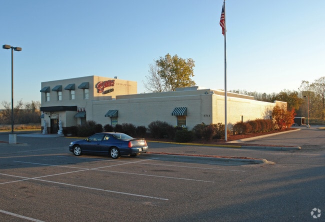
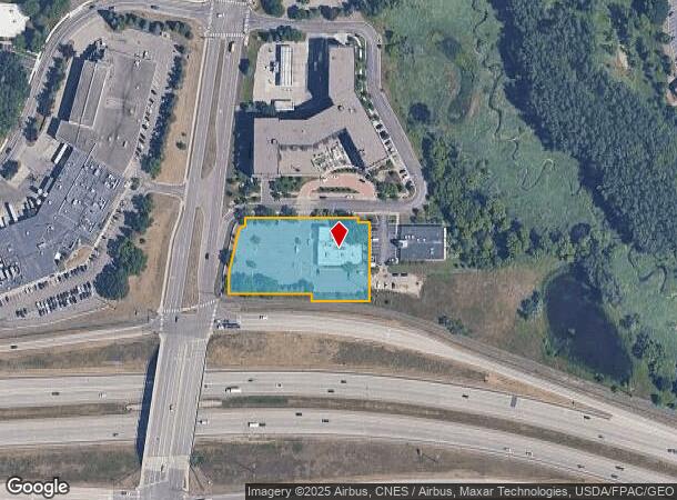
Property Record
7711 Mitchell Rd, Eden Prairie, MN 55344


NEARBY LISTINGS FOR SALE OR LEASE
Property Detail
7711 Mitchell Rd
Minneapolis-St. Paul-Bloomington, MN-WI
Edenvale Recreation Center 2Nd Addn
10-116-22-33-0038
LOT 002 BLOCK 001 B EDENVALE RECREATION CENTER 2ND ADDN LOT 2 BLK 1 EDENVALE RECREATION CENTER 2ND ADDN EXCEPT THAT PART THOF SHOWN AS PARCEL 92 ON MN/DOT R/W PLAT NO 27-91 ALSO THAT PART OF T IRREGULAR
Commercialnec
Hennepin
X
Minnesota
27053C0430F
2
2024
1.53 AC
2024
Eden Prairie
026007
Minneapolis/St Paul
8,971 SF
DEMOGRAPHICS near 7711 Mitchell Rd
1 Mile
3 Mile
5 Mile
2024 Total Population
8,182
54,477
139,614
2029 Population
8,037
53,511
138,823
Pop Growth 2024-2029
(1.77%)
(1.77%)
(0.57%)
Average Age
37
40
42
2024 Total Households
3,524
21,647
56,931
HH Growth 2024-2029
(2.01%)
(1.93%)
(0.65%)
Median Household Inc
$84,472
$112,241
$110,254
Avg Household Size
2.30
2.50
2.40
2024 Avg HH Vehicles
2.00
2.00
2.00
Median Home Value
$318,286
$418,544
$428,927
Median Year Built
1985
1987
1983
Nearby Places
Map Layers
Map Styles
 Street
 Aerial
- Restaurants
- Banks
- Shops
- Fitness
- Groceries
PUBLIC TRANSPORTATION
AIRPORT
Minneapolis-St Paul International/Wold-Chamberlain
DRIVE
WALK
Distance
Minneapolis-St Paul International/Wold-Chamberlain
21 min
13.8 mi
Freight Ports
Port Milwaukee
DRIVE
WALK
Distance
Port Milwaukee
390 min
351.0 mi
SALE & LEASE HISTORY
LISTING DATE
SALE/LEASE

Sep 12, 2018
For Sale
Nov 20, 2017
For Sale
Dec 14, 2021
For Sale
Nearby Properties
Address
Land Use
TOTAL SIZE
Lot Size
Zoning
Address
Land Use
TOTAL SIZE
Lot Size
Zoning
49,799 SF
4.96 AC
Address
Land Use
TOTAL SIZE
Lot Size
Zoning
4.89 AC
Address
Land Use
TOTAL SIZE
Lot Size
Zoning
Address
Land Use
TOTAL SIZE
Lot Size
Zoning
49,757 SF
2.88 AC
Address
Land Use
TOTAL SIZE
Lot Size
Zoning
138,997 SF
14.03 AC
OFC
Address
Land Use
TOTAL SIZE
Lot Size
Zoning
136,782 SF
6.17 AC
Address
Land Use
TOTAL SIZE
Lot Size
Zoning
3.15 AC
Address
Land Use
TOTAL SIZE
Lot Size
Zoning
216,984 SF
14.48 AC
RM25
Address
Land Use
TOTAL SIZE
Lot Size
Zoning
93,982 SF
9.33 AC
OFC
Address
Land Use
TOTAL SIZE
Lot Size
Zoning
226,252 SF
5.40 AC
Address
Land Use
TOTAL SIZE
Lot Size
Zoning
175,506 SF
14.32 AC
Address
Land Use
TOTAL SIZE
Lot Size
Zoning
10.01 AC
RM25
Address
Land Use
TOTAL SIZE
Lot Size
Zoning
314,234 SF
2.31 AC
RM25
Address
Land Use
TOTAL SIZE
Lot Size
Zoning
327,536 SF
4.76 AC
CCOM
Address
Land Use
TOTAL SIZE
Lot Size
Zoning
166,989 SF
9.70 AC
RM25
Address
Land Use
TOTAL SIZE
Lot Size
Zoning
181,201 SF
8.30 AC
OFC
Address
Land Use
TOTAL SIZE
Lot Size
Zoning
122,801 SF
8.41 AC
RM25
Address
Land Use
TOTAL SIZE
Lot Size
Zoning
9.94 AC
RM25
Address
Land Use
TOTAL SIZE
Lot Size
Zoning
12.57 AC
RM25
Address
Land Use
TOTAL SIZE
Lot Size
Zoning
7.30 AC
RM25
Address
Land Use
TOTAL SIZE
Lot Size
Zoning
5.77 AC
RM25
Address
Land Use
TOTAL SIZE
Lot Size
Zoning
325,341 SF
35.31 AC
C-REG
Address
Land Use
TOTAL SIZE
Lot Size
Zoning
298,582 SF
31.71 AC
OFC
Address
Land Use
TOTAL SIZE
Lot Size
Zoning
107,652 SF
9.82 AC
OFC
Address
Land Use
TOTAL SIZE
Lot Size
Zoning
130,990 SF
18.27 AC
C-REG
Address
Land Use
TOTAL SIZE
Lot Size
Zoning
8.38 AC
PUD
Address
Land Use
TOTAL SIZE
Lot Size
Zoning
536,598 SF
53.84 AC
I-5
Address
Land Use
TOTAL SIZE
Lot Size
Zoning
70,129 SF
13.03 AC
RM25
Address
Land Use
TOTAL SIZE
Lot Size
Zoning
129,037 SF
16.73 AC
RM25
Address
Land Use
TOTAL SIZE
Lot Size
Zoning
191,179 SF
22.62 AC
The World's #1 Commercial Real Estate Marketplace
Connect with us
© 2025 CoStar Group
The information above has been obtained from sources believed reliable. While we do not doubt its accuracy we have not verified it and make no guarantee, warranty or representation about it. It is your responsibility to independently confirm its accuracy and completeness. Any projections, opinions, assumptions, or estimates used are for example only and do not represent the current or future performance of the property. The value of this transaction to you depends on tax and other factors which should be evaluated by your tax, financial, and legal advisors. You and your advisors should conduct a careful, independent investigation of the property to determine to your satisfaction the suitability of the property for your needs.