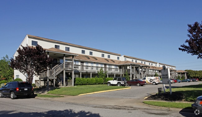
Property Record
7715 Harrisons Rd, Norfolk, VA 23505

Save to a Folder
{{folder.Name}}
{{folder.ListingIds.length}} Properties
{{folder.ListingIds.length}} Property
Create a New Folder
Property Detail
7715 Harrisons Rd
37627005
PARCEL B, 0.8675 ARCES & 95FT
Apartment
Norfolk City
C2
Virginia
B and X Area of moderate flood hazard, usually the area between the limits of the 100-year and 500-year floods.
3.85 AC
2025
North Meadow Brook
2025
Hampton Roads
001200
Virginia Beach-Chesapeake-Norfolk, VA-NC
59,184 SF
NEARBY LISTINGS FOR SALE OR LEASE
-
-
View all Norfolk listings for sale on LoopNet.com
DEMOGRAPHICS near 7715 Harrisons Rd
1 mile
3 mile
5 mile
2025 Total Population
12,135
68,184
180,138
2030 Population
11,842
67,336
177,317
Pop Growth 2025-2030
(2.41%)
(1.24%)
(1.57%)
Average Age
31
33
36
2025 Total Households
3,964
21,920
70,862
HH Growth 2025-2030
(2.88%)
(1.53%)
(1.71%)
Median Household Inc
$60,201
$57,467
$64,267
Avg Household Size
2.50
2.30
2.20
2025 Avg HH Vehicles
2.00
2.00
2.00
Median Home Value
$417,413
$376,644
$311,568
Median Year Built
1975
1962
1963
Nearby Places
Map Layers
Map Styles
 Street
 Aerial
Layers
 Traffic
 Biking
Places
Listings with unknown addresses are not visible on the map
- Restaurants
- Banks
- Shops
- Fitness
- Groceries
PUBLIC TRANSPORTATION
COMMUTER RAIL
Norfolk (Northeast Regional - Amtrak)
Drive
Walk
Distance
Norfolk (Northeast Regional - Amtrak)
13 min
7.7 mi
AIRPORT
Norfolk International
Drive
Walk
Distance
Norfolk International
13 min
7.1 mi
Newport News/Williamsburg International
Drive
Walk
Distance
Newport News/Williamsburg International
37 min
25.6 mi
Freight Ports
Virginia Port Authority - Norfolk
Drive
Walk
Distance
Virginia Port Authority - Norfolk
7 min
1.7 mi
Nearby Properties
Address
Land Use
TOTAL SIZE
Lot Size
Zoning
Address
Land Use
TOTAL SIZE
Lot Size
Zoning
3,436.58 AC
Address
Land Use
TOTAL SIZE
Lot Size
Zoning
1,190.45 AC
Address
Land Use
TOTAL SIZE
Lot Size
Zoning
842.34 AC
I5
Address
Land Use
TOTAL SIZE
Lot Size
Zoning
777.89 AC
Address
Land Use
TOTAL SIZE
Lot Size
Zoning
68,643 SF
24.68 AC
Address
Land Use
TOTAL SIZE
Lot Size
Zoning
213 AC
I5
Address
Land Use
TOTAL SIZE
Lot Size
Zoning
126,088 SF
4.91 AC
C2
Address
Land Use
TOTAL SIZE
Lot Size
Zoning
91,982 SF
22.78 AC
IN1
Address
Land Use
TOTAL SIZE
Lot Size
Zoning
10.40 AC
IN1
Address
Land Use
TOTAL SIZE
Lot Size
Zoning
235,750 SF
4.16 AC
UV
Address
Land Use
TOTAL SIZE
Lot Size
Zoning
11.09 AC
R14
Address
Land Use
TOTAL SIZE
Lot Size
Zoning
47,832 SF
7.51 AC
C2
Address
Land Use
TOTAL SIZE
Lot Size
Zoning
6,170 SF
18.46 AC
R13
Address
Land Use
TOTAL SIZE
Lot Size
Zoning
52,612 SF
4.94 AC
Address
Land Use
TOTAL SIZE
Lot Size
Zoning
14.02 AC
Address
Land Use
TOTAL SIZE
Lot Size
Zoning
31,291 SF
1.85 AC
Address
Land Use
TOTAL SIZE
Lot Size
Zoning
7.51 AC
IN2
Address
Land Use
TOTAL SIZE
Lot Size
Zoning
40,086 SF
4.81 AC
UV
Address
Land Use
TOTAL SIZE
Lot Size
Zoning
40,086 SF
4.95 AC
UV
Address
Land Use
TOTAL SIZE
Lot Size
Zoning
123,868 SF
0.12 AC
IN2
Address
Land Use
TOTAL SIZE
Lot Size
Zoning
36,530 SF
16.46 AC
IN1
Address
Land Use
TOTAL SIZE
Lot Size
Zoning
207,440 SF
3.74 AC
R12
Address
Land Use
TOTAL SIZE
Lot Size
Zoning
5.63 AC
IN2
Address
Land Use
TOTAL SIZE
Lot Size
Zoning
23.85 AC
IN1
Address
Land Use
TOTAL SIZE
Lot Size
Zoning
21.89 AC
IN1
Address
Land Use
TOTAL SIZE
Lot Size
Zoning
7.67 AC
IN2
Address
Land Use
TOTAL SIZE
Lot Size
Zoning
19.21 AC
MI
Address
Land Use
TOTAL SIZE
Lot Size
Zoning
18.39 AC
R11
Address
Land Use
TOTAL SIZE
Lot Size
Zoning
483,625 SF
2.55 AC
Address
Land Use
TOTAL SIZE
Lot Size
Zoning
3,944 SF
10.73 AC
R7
The World's #1 Commercial Real Estate Marketplace
Connect with us
© 2026 CoStar Group
The information above has been obtained from sources believed reliable. While we do not doubt its accuracy we have not verified it and make no guarantee, warranty or representation about it. It is your responsibility to independently confirm its accuracy and completeness. Any projections, opinions, assumptions, or estimates used are for example only and do not represent the current or future performance of the property. The value of this transaction to you depends on tax and other factors which should be evaluated by your tax, financial, and legal advisors. You and your advisors should conduct a careful, independent investigation of the property to determine to your satisfaction the suitability of the property for your needs.