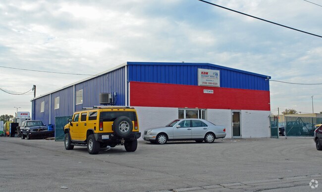
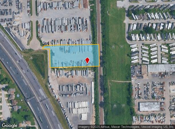
Property Record
7715 W 88Th St, Bridgeview, IL 60455

NEARBY LISTINGS FOR SALE OR LEASE
Property Detail
7715 W 88Th St
23-01-104-006-0000
Cook
Commercialnec
Illinois
X
2.15 AC
17031C0606J
North I-55 Corridor
2023
Chicago
2024
Chicago-Naperville-Elgin, IL-IN-WI
823703
DEMOGRAPHICS near 7715 W 88Th St
1 Mile
3 Mile
5 Mile
2024 Total Population
18,660
119,833
281,075
2029 Population
18,093
116,322
272,244
Pop Growth 2024-2029
(3.04%)
(2.93%)
(3.14%)
Average Age
39
40
40
2024 Total Households
6,436
42,894
102,071
HH Growth 2024-2029
(3.31%)
(3.24%)
(3.45%)
Median Household Inc
$59,869
$64,225
$70,145
Avg Household Size
2.80
2.70
2.70
2024 Avg HH Vehicles
2.00
2.00
2.00
Median Home Value
$232,906
$237,874
$243,245
Median Year Built
1975
1972
1966
Nearby Places
Map Layers
Map Styles
 Street
 Aerial
- Restaurants
- Banks
- Shops
- Fitness
- Groceries
PUBLIC TRANSPORTATION
COMMUTER RAIL
Chicago Ridge Station (SouthWest Service - Northeast Illinois Regional Commuter Railroad (Metra))
DRIVE
WALK
Distance
Chicago Ridge Station (SouthWest Service - Northeast Illinois Regional Commuter Railroad (Metra))
10 min
4.4 mi
Worth Station (SouthWest Service - Northeast Illinois Regional Commuter Railroad (Metra))
DRIVE
WALK
Distance
Worth Station (SouthWest Service - Northeast Illinois Regional Commuter Railroad (Metra))
10 min
4.5 mi
AIRPORT
Chicago Midway International
DRIVE
WALK
Distance
Chicago Midway International
15 min
8.1 mi
Chicago O'Hare International
DRIVE
WALK
Distance
Chicago O'Hare International
39 min
26.2 mi
Freight Ports
Port Milwaukee
DRIVE
WALK
Distance
Port Milwaukee
121 min
97.9 mi
Nearby Properties
Address
Land Use
TOTAL SIZE
Lot Size
Zoning
Address
Land Use
TOTAL SIZE
Lot Size
Zoning
Address
Land Use
TOTAL SIZE
Lot Size
Zoning
72,090 SF
10.19 AC
Address
Land Use
TOTAL SIZE
Lot Size
Zoning
266,580 SF
29.50 AC
Address
Land Use
TOTAL SIZE
Lot Size
Zoning
252,973 SF
11.68 AC
Address
Land Use
TOTAL SIZE
Lot Size
Zoning
51,762 SF
4 AC
Address
Land Use
TOTAL SIZE
Lot Size
Zoning
191,763 SF
15.63 AC
Address
Land Use
TOTAL SIZE
Lot Size
Zoning
61,003 SF
68.78 AC
Address
Land Use
TOTAL SIZE
Lot Size
Zoning
111,830 SF
2.16 AC
Address
Land Use
TOTAL SIZE
Lot Size
Zoning
198,190 SF
15 AC
Address
Land Use
TOTAL SIZE
Lot Size
Zoning
16,077 SF
66.23 AC
Address
Land Use
TOTAL SIZE
Lot Size
Zoning
397,288 SF
10.18 AC
Address
Land Use
TOTAL SIZE
Lot Size
Zoning
367,185 SF
25 AC
Address
Land Use
TOTAL SIZE
Lot Size
Zoning
28,406 SF
1.42 AC
Address
Land Use
TOTAL SIZE
Lot Size
Zoning
61,388 SF
2 AC
Address
Land Use
TOTAL SIZE
Lot Size
Zoning
256,416 SF
9.07 AC
Address
Land Use
TOTAL SIZE
Lot Size
Zoning
Address
Land Use
TOTAL SIZE
Lot Size
Zoning
8.32 AC
Address
Land Use
TOTAL SIZE
Lot Size
Zoning
202,309 SF
13.02 AC
Address
Land Use
TOTAL SIZE
Lot Size
Zoning
45,196 SF
1.28 AC
Address
Land Use
TOTAL SIZE
Lot Size
Zoning
19.48 AC
Address
Land Use
TOTAL SIZE
Lot Size
Zoning
127,984 SF
12.76 AC
Address
Land Use
TOTAL SIZE
Lot Size
Zoning
350,200 SF
Address
Land Use
TOTAL SIZE
Lot Size
Zoning
242,503 SF
8.83 AC
Address
Land Use
TOTAL SIZE
Lot Size
Zoning
43,271 SF
2.09 AC
Address
Land Use
TOTAL SIZE
Lot Size
Zoning
301,546 SF
11.59 AC
Address
Land Use
TOTAL SIZE
Lot Size
Zoning
145,018 SF
7.95 AC
Address
Land Use
TOTAL SIZE
Lot Size
Zoning
115,850 SF
10.08 AC
Address
Land Use
TOTAL SIZE
Lot Size
Zoning
132,579 SF
9.11 AC
Address
Land Use
TOTAL SIZE
Lot Size
Zoning
Address
Land Use
TOTAL SIZE
Lot Size
Zoning
20.71 AC
The World's #1 Commercial Real Estate Marketplace
Connect with us
© 2025 CoStar Group
The information above has been obtained from sources believed reliable. While we do not doubt its accuracy we have not verified it and make no guarantee, warranty or representation about it. It is your responsibility to independently confirm its accuracy and completeness. Any projections, opinions, assumptions, or estimates used are for example only and do not represent the current or future performance of the property. The value of this transaction to you depends on tax and other factors which should be evaluated by your tax, financial, and legal advisors. You and your advisors should conduct a careful, independent investigation of the property to determine to your satisfaction the suitability of the property for your needs.