Property Record
772 Hwy 4, Arnold, CA 95223
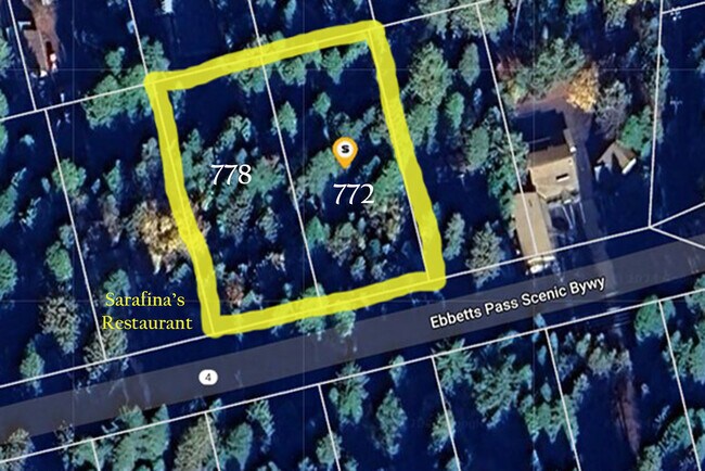
Property Detail
772 Hwy 4
026-019-060-000
MANUEL SUB LOT 6 BLK 3 POR OF OCTAVIA ST
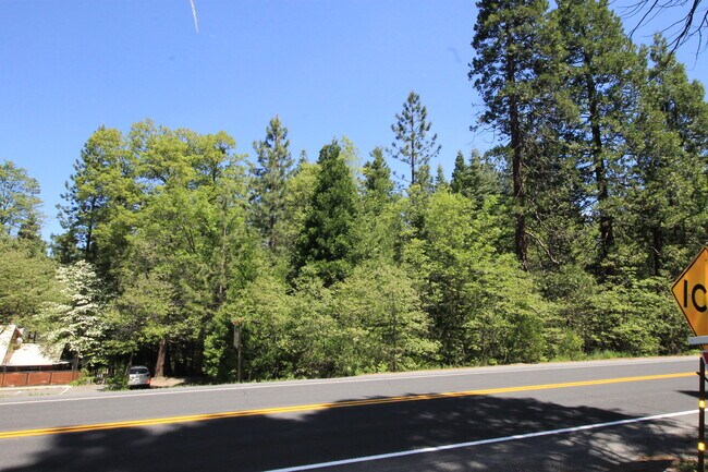
Commercialacreage
CALAVERAS
C2PD
California
B and X Area of moderate flood hazard, usually the area between the limits of the 100-year and 500-year floods.
6
2025
0.48 AC
2025
Merced/Central
000504
Other Market Areas
NEARBY LISTINGS FOR SALE OR LEASE
DEMOGRAPHICS near 772 Hwy 4
1 mile
3 mile
5 mile
2025 Total Population
1,271
3,565
3,975
2030 Population
1,266
3,560
3,956
Pop Growth 2025-2030
(0.39%)
(0.14%)
(0.48%)
Average Age
51
51
51
2025 Total Households
614
1,668
1,868
HH Growth 2025-2030
(0.65%)
(0.36%)
(0.75%)
Median Household Inc
$117,382
$90,224
$90,890
Avg Household Size
2.10
2.10
2.10
2025 Avg HH Vehicles
2.00
2.00
2.00
Median Home Value
$551,587
$548,951
$540,219
Median Year Built
1980
1981
1982
Nearby Places
Map Layers
Map Styles
 Street
 Aerial
Layers
 Traffic
 Biking
Places
Listings with unknown addresses are not visible on the map
- Restaurants
- Banks
- Shops
- Fitness
- Groceries
SALE & LEASE HISTORY
LISTING DATE
SALE/LEASE

Jul 10, 2024
For Sale
Nearby Properties
Address
Land Use
TOTAL SIZE
Lot Size
Zoning
Address
Land Use
TOTAL SIZE
Lot Size
Zoning
1.58 AC
C2
Address
Land Use
TOTAL SIZE
Lot Size
Zoning
665 SF
42.52 AC
REC
Address
Land Use
TOTAL SIZE
Lot Size
Zoning
0.57 AC
C1PDPX
Address
Land Use
TOTAL SIZE
Lot Size
Zoning
8,180 SF
0.29 AC
C1PD
Address
Land Use
TOTAL SIZE
Lot Size
Zoning
60,588 SF
0.52 AC
C1PDPX
Address
Land Use
TOTAL SIZE
Lot Size
Zoning
3.63 AC
C2PD
Address
Land Use
TOTAL SIZE
Lot Size
Zoning
14,002 SF
2.31 AC
REC
Address
Land Use
TOTAL SIZE
Lot Size
Zoning
4,272 SF
1.42 AC
C1
Address
Land Use
TOTAL SIZE
Lot Size
Zoning
7.04 AC
Address
Land Use
TOTAL SIZE
Lot Size
Zoning
0.80 AC
C2PD
Address
Land Use
TOTAL SIZE
Lot Size
Zoning
3,098 SF
0.60 AC
C2
Address
Land Use
TOTAL SIZE
Lot Size
Zoning
5,176 SF
1.15 AC
C1PD
Address
Land Use
TOTAL SIZE
Lot Size
Zoning
3,443 SF
5.29 AC
RR25R125
Address
Land Use
TOTAL SIZE
Lot Size
Zoning
0.41 AC
C1PDPX
Address
Land Use
TOTAL SIZE
Lot Size
Zoning
6,436 SF
0.44 AC
C2PD
Address
Land Use
TOTAL SIZE
Lot Size
Zoning
3,089 SF
5 AC
RR5
Address
Land Use
TOTAL SIZE
Lot Size
Zoning
3,823 SF
5.20 AC
R1
Address
Land Use
TOTAL SIZE
Lot Size
Zoning
3,052 SF
1.02 AC
C2PD
Address
Land Use
TOTAL SIZE
Lot Size
Zoning
1,264 SF
21.08 AC
REC
Address
Land Use
TOTAL SIZE
Lot Size
Zoning
2,720 SF
14.90 AC
R1
Address
Land Use
TOTAL SIZE
Lot Size
Zoning
23 AC
REC
Address
Land Use
TOTAL SIZE
Lot Size
Zoning
3,046 SF
5.06 AC
R1
Address
Land Use
TOTAL SIZE
Lot Size
Zoning
2,376 SF
47.53 AC
AP
Address
Land Use
TOTAL SIZE
Lot Size
Zoning
18,046 SF
1.36 AC
C2PD
Address
Land Use
TOTAL SIZE
Lot Size
Zoning
15,424 SF
5 AC
M1
Address
Land Use
TOTAL SIZE
Lot Size
Zoning
11,432 SF
1.27 AC
C2PD
Address
Land Use
TOTAL SIZE
Lot Size
Zoning
3,000 SF
10.23 AC
RR5
Address
Land Use
TOTAL SIZE
Lot Size
Zoning
0.26 AC
R1
Address
Land Use
TOTAL SIZE
Lot Size
Zoning
3,176 SF
7.66 AC
R1PD
Address
Land Use
TOTAL SIZE
Lot Size
Zoning
1.22 AC
C1PD
The World's #1 Commercial Real Estate Marketplace
Connect with us
© 2026 CoStar Group
The information above has been obtained from sources believed reliable. While we do not doubt its accuracy we have not verified it and make no guarantee, warranty or representation about it. It is your responsibility to independently confirm its accuracy and completeness. Any projections, opinions, assumptions, or estimates used are for example only and do not represent the current or future performance of the property. The value of this transaction to you depends on tax and other factors which should be evaluated by your tax, financial, and legal advisors. You and your advisors should conduct a careful, independent investigation of the property to determine to your satisfaction the suitability of the property for your needs.