Property Record
7721 S Staples St, Corpus Christi, TX 78413
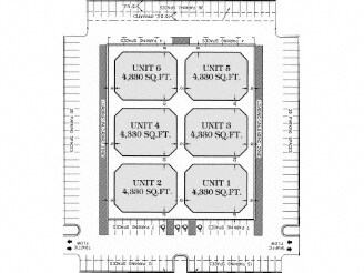

Property Detail
7721 S Staples St
375912
KINGS CROSSING WEST UNIT 2 BLK 2 LOT 2
Commercialnec
NUECES
B4
Texas
B and X Area of moderate flood hazard, usually the area between the limits of the 100-year and 500-year floods.
2
2024
1.70 AC
2025
South Side
005412
Corpus Christi
10,687 SF
Corpus Christi, TX
NEARBY LISTINGS FOR SALE OR LEASE
DEMOGRAPHICS near 7721 S Staples St
1 mile
3 mile
5 mile
2025 Total Population
10,130
74,812
144,203
2030 Population
9,991
74,292
142,414
Pop Growth 2025-2030
(1.37%)
(0.70%)
(1.24%)
Average Age
39
38
38
2025 Total Households
3,392
27,722
54,233
HH Growth 2025-2030
(1.44%)
(1.00%)
(1.48%)
Median Household Inc
$105,829
$85,943
$73,658
Avg Household Size
2.90
2.60
2.60
2025 Avg HH Vehicles
2.00
2.00
2.00
Median Home Value
$321,976
$271,694
$236,939
Median Year Built
1997
1995
1986
Nearby Places
Map Layers
Map Styles
 Street
 Aerial
Transit
 Traffic
 Biking
Places
Listings with unknown addresses are not visible on the map
- Restaurants
- Banks
- Shops
- Fitness
- Groceries
PUBLIC TRANSPORTATION
AIRPORT
Corpus Christi International
Drive
Walk
Distance
Corpus Christi International
25 min
15.4 mi
Freight Ports
Port of Corpus Christi
Drive
Walk
Distance
Port of Corpus Christi
20 min
12.2 mi
Nearby Properties
Address
Land Use
TOTAL SIZE
Lot Size
Zoning
Address
Land Use
TOTAL SIZE
Lot Size
Zoning
248,852 SF
50.64 AC
Address
Land Use
TOTAL SIZE
Lot Size
Zoning
380,000 SF
71.08 AC
Address
Land Use
TOTAL SIZE
Lot Size
Zoning
97,505 SF
29.76 AC
B-4
Address
Land Use
TOTAL SIZE
Lot Size
Zoning
273,740 SF
16.74 AC
A1
Address
Land Use
TOTAL SIZE
Lot Size
Zoning
111,464 SF
18.63 AC
R1C
Address
Land Use
TOTAL SIZE
Lot Size
Zoning
196,076 SF
13.25 AC
Address
Land Use
TOTAL SIZE
Lot Size
Zoning
96,495 SF
6.63 AC
AB
Address
Land Use
TOTAL SIZE
Lot Size
Zoning
96,546 SF
19.99 AC
Address
Land Use
TOTAL SIZE
Lot Size
Zoning
124,257 SF
7.63 AC
Address
Land Use
TOTAL SIZE
Lot Size
Zoning
97,799 SF
8.35 AC
Address
Land Use
TOTAL SIZE
Lot Size
Zoning
88,260 SF
5 AC
Address
Land Use
TOTAL SIZE
Lot Size
Zoning
126,787 SF
13.58 AC
R1B
Address
Land Use
TOTAL SIZE
Lot Size
Zoning
79,107 SF
9.54 AC
R1B
Address
Land Use
TOTAL SIZE
Lot Size
Zoning
9,202 SF
126.97 AC
R1B
Address
Land Use
TOTAL SIZE
Lot Size
Zoning
124,511 SF
10.74 AC
B-3
Address
Land Use
TOTAL SIZE
Lot Size
Zoning
81,798 SF
23.13 AC
A2
Address
Land Use
TOTAL SIZE
Lot Size
Zoning
68,535 SF
10.88 AC
V
Address
Land Use
TOTAL SIZE
Lot Size
Zoning
66,412 SF
4.10 AC
I-2
Address
Land Use
TOTAL SIZE
Lot Size
Zoning
174,134 SF
19.26 AC
B4
Address
Land Use
TOTAL SIZE
Lot Size
Zoning
83,945 SF
13.34 AC
R2
Address
Land Use
TOTAL SIZE
Lot Size
Zoning
72,436 SF
7.55 AC
B1
Address
Land Use
TOTAL SIZE
Lot Size
Zoning
56,218 SF
15 AC
Address
Land Use
TOTAL SIZE
Lot Size
Zoning
77,977 SF
11.93 AC
B-4
Address
Land Use
TOTAL SIZE
Lot Size
Zoning
157,011 SF
15.44 AC
Address
Land Use
TOTAL SIZE
Lot Size
Zoning
59,146 SF
8.65 AC
FR
Address
Land Use
TOTAL SIZE
Lot Size
Zoning
2,400 SF
4.78 AC
Address
Land Use
TOTAL SIZE
Lot Size
Zoning
49,640 SF
9.99 AC
B4
Address
Land Use
TOTAL SIZE
Lot Size
Zoning
44,115 SF
3.44 AC
R1B
Address
Land Use
TOTAL SIZE
Lot Size
Zoning
38,995 SF
9 AC
A1
Address
Land Use
TOTAL SIZE
Lot Size
Zoning
36,770 SF
11.56 AC
B-4,R-1B
The World's #1 Commercial Real Estate Marketplace
Connect with us
© 2026 CoStar Group
The information above has been obtained from sources believed reliable. While we do not doubt its accuracy we have not verified it and make no guarantee, warranty or representation about it. It is your responsibility to independently confirm its accuracy and completeness. Any projections, opinions, assumptions, or estimates used are for example only and do not represent the current or future performance of the property. The value of this transaction to you depends on tax and other factors which should be evaluated by your tax, financial, and legal advisors. You and your advisors should conduct a careful, independent investigation of the property to determine to your satisfaction the suitability of the property for your needs.