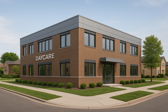
Property Record
7728 N Sheridan Rd, Chicago, IL 60626


Current Lease Availabilities
NEARBY LISTINGS FOR SALE OR LEASE
Property Detail
7728 N Sheridan Rd
Chicago-Naperville-Elgin, IL-IN-WI
Fergusons Birchwood Add To Evanston
11-29-102-039-0000
(FERGUSONS)(BIRCHWOOD) ADD TO (EVANSTON) PT SH NW N O F THE I.B.L. SH NW SEC 29-41-14
Vacantlandnec
Cook
X
Illinois
17031C0268K
1,2
2023
0.21 AC
2025
Northwest City
010100
Chicago
2,097 SF
DEMOGRAPHICS near 7728 N Sheridan Rd
1 Mile
3 Mile
5 Mile
2024 Total Population
45,660
254,107
561,562
2029 Population
44,379
246,968
544,629
Pop Growth 2024-2029
(2.81%)
(2.81%)
(3.02%)
Average Age
40
39
40
2024 Total Households
21,528
107,541
239,205
HH Growth 2024-2029
(3.08%)
(2.99%)
(3.25%)
Median Household Inc
$61,501
$61,729
$72,029
Avg Household Size
2.00
2.20
2.20
2024 Avg HH Vehicles
1.00
1.00
1.00
Median Home Value
$284,626
$332,313
$383,552
Median Year Built
1948
1949
1949
Nearby Places
Map Layers
Map Styles
 Street
 Aerial
- Restaurants
- Banks
- Shops
- Fitness
- Groceries
PUBLIC TRANSPORTATION
TRANSIT/SUBWAY
Howard Terminal (Purple Line - Chicago Transit Authority "L" Trains (The "L"), Red Line - Chicago Transit Authority "L" Trains (The "L"), Yellow Line - Chicago Transit Authority "L" Trains (The "L"))
DRIVE
WALK
Distance
Howard Terminal (Purple Line - Chicago Transit Authority "L" Trains (The "L"), Red Line - Chicago Transit Authority "L" Trains (The "L"), Yellow Line - Chicago Transit Authority "L" Trains (The "L"))
1 min
9 min
0.5 mi
Jarvis Station (Red Line - Chicago Transit Authority "L" Trains (The "L"))
DRIVE
WALK
Distance
Jarvis Station (Red Line - Chicago Transit Authority "L" Trains (The "L"))
1 min
10 min
0.5 mi
South Boulevard Station (Purple Line - Chicago Transit Authority "L" Trains (The "L"))
DRIVE
WALK
Distance
South Boulevard Station (Purple Line - Chicago Transit Authority "L" Trains (The "L"))
1 min
17 min
0.9 mi
COMMUTER RAIL
Rogers Park Station (Union Pacific North Line - Northeast Illinois Regional Commuter Railroad (Metra))
DRIVE
WALK
Distance
Rogers Park Station (Union Pacific North Line - Northeast Illinois Regional Commuter Railroad (Metra))
3 min
1.3 mi
Evanston Main Street Station (Union Pacific North Line - Northeast Illinois Regional Commuter Railroad (Metra))
DRIVE
WALK
Distance
Evanston Main Street Station (Union Pacific North Line - Northeast Illinois Regional Commuter Railroad (Metra))
3 min
1.4 mi
AIRPORT
Chicago O'Hare International
DRIVE
WALK
Distance
Chicago O'Hare International
27 min
15.4 mi
Chicago Midway International
DRIVE
WALK
Distance
Chicago Midway International
33 min
22.5 mi
Freight Ports
Port Milwaukee
DRIVE
WALK
Distance
Port Milwaukee
95 min
76.1 mi
Nearby Properties
Address
Land Use
TOTAL SIZE
Lot Size
Zoning
Address
Land Use
TOTAL SIZE
Lot Size
Zoning
0.63 AC
PD 1372
Address
Land Use
TOTAL SIZE
Lot Size
Zoning
180,397 SF
0.78 AC
Address
Land Use
TOTAL SIZE
Lot Size
Zoning
0.63 AC
Address
Land Use
TOTAL SIZE
Lot Size
Zoning
892,012 SF
37.29 AC
Address
Land Use
TOTAL SIZE
Lot Size
Zoning
341,698 SF
0.64 AC
Address
Land Use
TOTAL SIZE
Lot Size
Zoning
305,592 SF
27.35 AC
Address
Land Use
TOTAL SIZE
Lot Size
Zoning
4,748 SF
0.40 AC
Address
Land Use
TOTAL SIZE
Lot Size
Zoning
303,960 SF
0.98 AC
Address
Land Use
TOTAL SIZE
Lot Size
Zoning
0.84 AC
Address
Land Use
TOTAL SIZE
Lot Size
Zoning
82,139 SF
4.88 AC
Address
Land Use
TOTAL SIZE
Lot Size
Zoning
251,409 SF
16.33 AC
Address
Land Use
TOTAL SIZE
Lot Size
Zoning
176,115 SF
1.04 AC
Address
Land Use
TOTAL SIZE
Lot Size
Zoning
218,982 SF
1.97 AC
Address
Land Use
TOTAL SIZE
Lot Size
Zoning
243,781 SF
0.84 AC
Address
Land Use
TOTAL SIZE
Lot Size
Zoning
110,528 SF
3.05 AC
Address
Land Use
TOTAL SIZE
Lot Size
Zoning
63,700 SF
7.42 AC
PD 796
Address
Land Use
TOTAL SIZE
Lot Size
Zoning
Address
Land Use
TOTAL SIZE
Lot Size
Zoning
145,548 SF
0.80 AC
Address
Land Use
TOTAL SIZE
Lot Size
Zoning
8,550 SF
0.25 AC
Address
Land Use
TOTAL SIZE
Lot Size
Zoning
1.67 AC
Address
Land Use
TOTAL SIZE
Lot Size
Zoning
2.46 AC
Address
Land Use
TOTAL SIZE
Lot Size
Zoning
208,785 SF
0.61 AC
Address
Land Use
TOTAL SIZE
Lot Size
Zoning
190,350 SF
1.03 AC
Address
Land Use
TOTAL SIZE
Lot Size
Zoning
0.30 AC
Address
Land Use
TOTAL SIZE
Lot Size
Zoning
0.38 AC
Address
Land Use
TOTAL SIZE
Lot Size
Zoning
223,366 SF
0.65 AC
Address
Land Use
TOTAL SIZE
Lot Size
Zoning
83,966 SF
0.76 AC
RM-5.5
Address
Land Use
TOTAL SIZE
Lot Size
Zoning
1.01 AC
RM-6,POS-1
Address
Land Use
TOTAL SIZE
Lot Size
Zoning
0.16 AC
RM-6
Address
Land Use
TOTAL SIZE
Lot Size
Zoning
72,503 SF
5.60 AC
The World's #1 Commercial Real Estate Marketplace
Connect with us
© 2026 CoStar Group
The information above has been obtained from sources believed reliable. While we do not doubt its accuracy we have not verified it and make no guarantee, warranty or representation about it. It is your responsibility to independently confirm its accuracy and completeness. Any projections, opinions, assumptions, or estimates used are for example only and do not represent the current or future performance of the property. The value of this transaction to you depends on tax and other factors which should be evaluated by your tax, financial, and legal advisors. You and your advisors should conduct a careful, independent investigation of the property to determine to your satisfaction the suitability of the property for your needs.